Twelve O'clock Knob facts for kids
Quick facts for kids Twelve O'clock Knob |
|
|---|---|

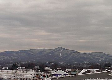
Looking southwest at Twelve O'clock Knob
|
|
| Highest point | |
| Elevation | 2,671 ft (814 m) |
| Geography | |
| Location | Roanoke County, Virginia, U.S. |
| Parent range | Appalachian Mountains, Blue Ridge Mountains |
| Topo map | USGS Bent Mountain |
| Climbing | |
| Easiest route | Road |
Twelve O'clock Knob is a mountain in southwestern Roanoke County, Virginia. It's located just south of Salem. This mountain has a unique name with an interesting story!
Contents
Why is it Called Twelve O'clock Knob?
Long ago, people living in the western Roanoke Valley had a special way to tell time. They noticed that the Sun was directly above this mountain around noon each day. This helped them know when it was about "twelve o'clock" local time. That's how the mountain got its name!
Where is Twelve O'clock Knob Located?
Twelve O'clock Knob is part of the Appalachian Mountains and the Blue Ridge Mountains. It stands 2,671 feet (814 meters) tall. The mountain is in Roanoke County, Virginia, in the United States.
A Natural Boundary
This mountain, along with Poor Mountain and other nearby peaks like Sugarloaf Mountain, forms a natural border. Their northern slopes mark the southwestern edge of the Roanoke Valley.
Famous Bike Race
In the mid-1990s, Twelve O'clock Knob became famous for a bike race. The Tour DuPont was a big cycling event held in the Roanoke Valley. In 1995 and 1996, a special part of the race was a time trial. This meant cyclists raced against the clock over the challenging Twelve O'clock Knob Road. It was a steep and winding path, making it a tough test for the riders!
Not to Be Confused
It's important to know that there is another mountain with a very similar name. Twelve O'Clock Knob in Patrick County, Virginia is a different place. Make sure you don't mix them up!
 | Bayard Rustin |
 | Jeannette Carter |
 | Jeremiah A. Brown |

