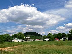
Hunter, Tennessee facts for kids
Quick facts for kids
Hunter
Stoney Creek
|
|
|---|---|
 |
|

Location of Hunter, Tennessee
|
|
| Country | United States |
| State | Tennessee |
| County | Carter |
| Area | |
| • Total | 6.42 sq mi (16.64 km2) |
| • Land | 6.40 sq mi (16.57 km2) |
| • Water | 0.03 sq mi (0.07 km2) |
| Elevation | 1,568 ft (478 m) |
| Population
(2020)
|
|
| • Total | 1,803 |
| • Density | 281.85/sq mi (108.83/km2) |
| Time zone | UTC-5 (Eastern (EST)) |
| • Summer (DST) | UTC-4 (EDT) |
| ZIP code |
37643
|
| Area code(s) | 423 |
| FIPS code | 47-36500 |
| GNIS feature ID | 1328513 |
Hunter, also known as Stoney Creek, is a small community in Carter County, Tennessee. It's located in the northeastern part of the county, near the city of Elizabethton. You can find it along Tennessee State Route 91 and the Watauga River. According to the 2020 census, about 1,803 people call Hunter home.
Hunter is part of the larger Johnson City metropolitan area. This area is also known as the "Tri-Cities" region, which includes Johnson City, Kingsport, and Bristol. Hunter is like a smaller town right next to Elizabethton.
Contents
Where is Hunter Located?
Hunter is located at specific geographic coordinates: 36°22′36″N 82°9′18″W / 36.37667°N 82.15500°W. This means it's at 36.376630 degrees North and -82.155032 degrees West.
The United States Census Bureau says that Hunter covers a total area of about 6.411 square miles (16.60 square kilometers). Most of this area, about 6.386 square miles (16.54 square kilometers), is land. A very small part, about 0.025 square miles (0.06 square kilometers), is water.
The Watauga River forms the southern border of the Hunter community. To the north, you'll find Holston Mountain.
Who Lives in Hunter?
| Historical population | |||
|---|---|---|---|
| Census | Pop. | %± | |
| 2020 | 1,803 | — | |
| U.S. Decennial Census | |||

In 2000, there were 1,566 people living in Hunter. These people lived in 689 households, and 491 of these were families. The community had about 255 people per square mile (98 people per square kilometer).
Most of the people living in Hunter were White (99.17%). A small number were African American, Native American, or Asian. About 1.15% of the population identified as Hispanic or Latino.
About 27.7% of households had children under 18 living with them. Many households (57.9%) were married couples. The average household had about 2.27 people, and the average family had about 2.71 people.
The population of Hunter included people of all ages. About 19.3% were under 18 years old. About 16.7% were 65 years or older. The average age of people in Hunter was 41 years old.
Schools in Hunter
The schools in Hunter and Stoney Creek are managed by the Carter County Schools system. These schools help students learn and grow:
- Hunter Elementary – This school teaches students from pre-kindergarten up to 8th grade.
- Unaka Elementary – This school also teaches students from pre-kindergarten up to 8th grade.
- Unaka High – This high school is for older students, from 9th to 12th grade.
The Northeast State Community College also has a campus near Hunter, in Elizabethton.
How to Get to Hunter
If you're traveling by car, here's how you can reach Hunter using major roads:
- Take Interstate 26 to Exit 24 in Johnson City, Tennessee.
- From there, head east on Tennessee State Route 67 to Elizabethton, Tennessee.
- Then, turn left onto Tennessee State Route 67 / US 19E.
- Finally, turn right onto Tennessee State Route 91 at the Stoney Creek Exit, which will lead you to Hunter.
See also
 In Spanish: Hunter (Tennessee) para niños
 | Jewel Prestage |
 | Ella Baker |
 | Fannie Lou Hamer |

