Hancock County, Tennessee facts for kids
Quick facts for kids
Hancock County
|
||
|---|---|---|

Hancock County Courthouse in Sneedville
|
||
|
||

Location within the U.S. state of Tennessee
|
||
 Tennessee's location within the U.S. |
||
| Country | ||
| State | ||
| Founded | 1844 | |
| Named for | John Hancock | |
| Seat | Sneedville | |
| Largest town | Sneedville | |
| Area | ||
| • Total | 223 sq mi (580 km2) | |
| • Land | 222 sq mi (570 km2) | |
| • Water | 1.2 sq mi (3 km2) 0.5%% | |
| Population
(2020)
|
||
| • Total | 6,662 |
|
| • Density | 31/sq mi (12/km2) | |
| Time zone | UTC−5 (Eastern) | |
| • Summer (DST) | UTC−4 (EDT) | |
| Congressional district | 1st | |
Hancock County is a county located in the northeastern part of Tennessee. It is a state in the United States. In 2020, about 6,662 people lived there. This makes it one of the smallest counties in Tennessee by population. The main town and county seat is Sneedville.
Contents
History of Hancock County
Hancock County was formed from parts of two other counties. These were Hawkins County and Claiborne County. The state government decided to create the county in 1844. However, some people from Hawkins County did not agree. They went to court to try and stop it.
In 1848, the Tennessee Supreme Court made a decision. They said the new county could be created. The county's main town, Sneedville, was named after William H. Sneed. He was the lawyer who helped the county win its court case. The county itself was named after John Hancock. He was a famous leader during the American Revolutionary War.
Geography and Nature
Hancock County covers about 223 square miles. Most of this area is land. Only a small part, about 1.2 square miles, is water. This means it is mostly land, with a few rivers or lakes.
Which Counties are Nearby?
Hancock County shares its borders with several other counties:
- Lee County, Virginia (to the north)
- Scott County, Virginia (to the northeast)
- Hawkins County (to the east)
- Grainger County (to the southwest)
- Claiborne County (to the west)
Protected Natural Areas
Part of the Kyles Ford Wildlife Management Area is in Hancock County. This area helps protect local wildlife and nature.
Main Roads in the County
Several important roads go through Hancock County. These roads help people travel to and from different communities.
 SR 31: Connects to other main roads and Hawkins County.
 SR 33: Goes through Kyles Ford and into Virginia. It also goes south to Tazewell.
 SR 63: Leads to Harrogate and northern Claiborne County.
 SR 70: Heads towards the Virginia border and Rogersville to the south.
 SR 131: Connects to other major routes and northeast Grainger County.
- Back Valley Road: Links downtown Sneedville with other small communities.
People and Population
| Historical population | |||
|---|---|---|---|
| Census | Pop. | %± | |
| 1850 | 5,660 | — | |
| 1860 | 7,020 | 24.0% | |
| 1870 | 7,148 | 1.8% | |
| 1880 | 9,098 | 27.3% | |
| 1890 | 10,342 | 13.7% | |
| 1900 | 11,147 | 7.8% | |
| 1910 | 10,778 | −3.3% | |
| 1920 | 10,454 | −3.0% | |
| 1930 | 9,673 | −7.5% | |
| 1940 | 11,231 | 16.1% | |
| 1950 | 9,116 | −18.8% | |
| 1960 | 7,757 | −14.9% | |
| 1970 | 6,719 | −13.4% | |
| 1980 | 6,887 | 2.5% | |
| 1990 | 6,739 | −2.1% | |
| 2000 | 6,786 | 0.7% | |
| 2010 | 6,819 | 0.5% | |
| 2020 | 6,662 | −2.3% | |
| U.S. Decennial Census 1790-1960 1900-1990 1990-2000 2010-2020 2020 |
|||
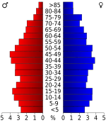
The number of people living in Hancock County has changed over the years. In 2020, the population was 6,662 people. There were 2,742 households, which are groups of people living together. There were also 1,729 families.
In 2010, there were 6,819 people in the county. Most people living there were White. A small number of people were Black or African American, Native American, or Asian. Some people were of two or more races. A very small percentage were Hispanic or Latino.
Local Culture
Hancock County is known for its Melungeon population. Melungeons are a group of people believed to have mixed European, African, and Native American backgrounds.
The Vardy Community School is an important historical site here. This school provided education for Melungeon children many years ago. It is located in the Newman's Ridge area and teaches about the county's unique history.
Towns and Communities
Hancock County has one main town and several smaller communities.
Main Town
- Sneedville (This is the county seat, where the main government offices are.)
Smaller Communities
These are places where people live, but they are not officially towns or cities:
- Alanthus Hill
- Kyles Ford
- Mulberry Gap
- Treadway
- Xenophon
Education in Hancock County
There is one main school district in the county. It is called the Hancock County School District. This district manages all the public schools in the area.
See also
 In Spanish: Condado de Hancock (Tennessee) para niños
 | Jessica Watkins |
 | Robert Henry Lawrence Jr. |
 | Mae Jemison |
 | Sian Proctor |
 | Guion Bluford |


