Stickleyville, Virginia facts for kids
Quick facts for kids
Stickleyville, Virginia
|
|
|---|---|

Stickleyville
|
|
| Country | United States |
| State | Virginia |
| County | Lee |
| Area | |
| • Total | 2.85 sq mi (7.38 km2) |
| • Land | 2.85 sq mi (7.38 km2) |
| • Water | 0 sq mi (0.0 km2) |
| Elevation | 1,631 ft (497 m) |
| Time zone | UTC−5 (Eastern (EST)) |
| • Summer (DST) | UTC−4 (EDT) |
| GNIS feature ID | 1475137 |
Stickleyville is a small place in Lee County, Virginia, in the United States. It's called an unincorporated community. This means it's a group of homes and businesses that isn't officially a town or city with its own local government. It's also a census-designated place (CDP). This just means the government counts the people living there for the census. The area was also known as Stickleysville in the past.
About Stickleyville, Virginia
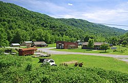
Stickleyville is located in the beautiful state of Virginia. It is part of Lee County. The community sits along a road called U.S. Route 421. This road is close to the border between Lee County and Scott County.
Where is Stickleyville Located?
The community is found in a place called the Wallen Creek Valley. If you travel east from Stickleyville, you would cross Powell Mountain to reach Duffield. If you go northwest, you would cross Wallen Ridge to get to Pennington Gap. These natural features help define the area around Stickleyville.
The History of Stickleyville
Stickleyville has a history that goes back many years. A post office was first opened here in 1850. At that time, it was called Stickleysville. The community got its name from an early settler named Vastine Stickley. He was one of the first people to live in this area.
 | William M. Jackson |
 | Juan E. Gilbert |
 | Neil deGrasse Tyson |


