
Cumberland Gap, Tennessee facts for kids
Quick facts for kids
Cumberland Gap, Tennessee
|
|
|---|---|

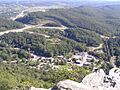
Cumberland Gap, as viewed from the Pinnacle Overlook
|
|
| Nickname(s):
The Gap
|
|

Location of Cumberland Gap in Claiborne County, Tennessee.
|
|
| Country | United States |
| State | Tennessee |
| County | Claiborne |
| Settled | 1770s |
| Incorporated | 1907 |
| Named for | Cumberland Gap mountain pass |
| Government | |
| • Type | Mayor-council |
| Area | |
| • Total | 0.33 sq mi (0.85 km2) |
| • Land | 0.33 sq mi (0.85 km2) |
| • Water | 0.00 sq mi (0.00 km2) |
| Elevation | 1,417 ft (432 m) |
| Population
(2020)
|
|
| • Total | 313 |
| • Density | 951.37/sq mi (367.34/km2) |
| Time zone | UTC-5 (Eastern (EST)) |
| • Summer (DST) | UTC-4 (EDT) |
| ZIP codes |
37724, 37752
|
| Area code(s) | 423 |
| FIPS code | 47-18880 |
| GNIS feature ID | 2406347 |
Cumberland Gap is a small town in Claiborne County, Tennessee, United States. In 2020, about 313 people lived there. The town is located right below the Cumberland Gap, a famous mountain pass that the town is named after. It is also inside the Cumberland Gap National Historical Park.
Most of the town's main area is listed on the National Register of Historic Places. This means it is recognized as an important historical site.
Contents
History of Cumberland Gap
Early Paths and Explorers
Long ago, Native American tribes like the Cherokee and Shawnee used a path through the mountains. The Shawnee called it Athiamiowee. This path was sometimes called "The Warriors' Path" because tribes and early settlers sometimes fought there. The area known as the Cumberland Gap was a key gateway on this path.
Even though many explorers had used the pass, Thomas Walker is often given credit for "discovering" it for settlers. He was hired to find a good spot for a new settlement west of the mountains.
Town Growth and the Civil War
Cumberland Gap became a place with a post office in 1803. It officially became a town in 1907. During the American Civil War, the town was taken over four times by different armies. However, no big battles actually happened right in the town itself.
Building and Bypassing
In 1888, a man named Alexander Arthur started a work camp in Cumberland Gap. He needed workers to build a tunnel for a railroad. Arthur wanted to create a large iron-making business in the area. He also founded nearby towns like Middlesboro, Kentucky, and Harrogate, Tennessee.
In 1996, the Cumberland Gap Tunnel was finished. This new tunnel rerouted a main road, US 25E, away from the town's center. Because of this, fewer people drove through the town. This caused the local economy to slow down. The money earned by businesses in Cumberland Gap dropped by 40% in ten years after the tunnel opened.
Geography of Cumberland Gap
Cumberland Gap is located at 36°35′56″N 83°40′2″W / 36.59889°N 83.66722°W. The United States Census Bureau says the town covers about 0.3 square miles (0.8 square kilometers) of land. There is no water area within the town limits.
People in Cumberland Gap
Population Changes Over Time
The number of people living in Cumberland Gap has changed over the years. Here's a look at the population at different times:
| Historical population | |||
|---|---|---|---|
| Census | Pop. | %± | |
| 1910 | 347 | — | |
| 1920 | 304 | −12.4% | |
| 1930 | 369 | 21.4% | |
| 1940 | 409 | 10.8% | |
| 1950 | 403 | −1.5% | |
| 1960 | 291 | −27.8% | |
| 1970 | 231 | −20.6% | |
| 1980 | 263 | 13.9% | |
| 1990 | 210 | −20.2% | |
| 2000 | 204 | −2.9% | |
| 2010 | 494 | 142.2% | |
| 2020 | 313 | −36.6% | |
| Sources: | |||
Who Lives in Cumberland Gap?
The 2020 United States census showed that 313 people lived in Cumberland Gap. There were 115 households and 48 families.
Here's a breakdown of the different groups of people living in Cumberland Gap in 2020:
| Group | Number | Percentage |
|---|---|---|
| White (not Hispanic) | 265 | 84.66% |
| Black or African American (not Hispanic) | 9 | 2.88% |
| Native American | 1 | 0.32% |
| Asian | 22 | 7.03% |
| Other/Mixed | 10 | 3.19% |
| Hispanic or Latino | 6 | 1.92% |
Economy of Cumberland Gap
The main jobs for people in Cumberland Gap are in healthcare, education, arts, and service industries. Jobs related to food preparation and service are growing the fastest in the town.
However, most people who live in Cumberland Gap do not work in the town itself. They usually travel to other parts of Claiborne County, Middlesboro, or Campbell County for work.
Arts and Culture in Cumberland Gap
Festivals and Events
Cumberland Gap hosts several fun festivals and events throughout the year. Some of the most popular ones include:
- White Lightning Trail Festival - This festival happens every May. It celebrates the history and culture of East Tennessee, pioneer life, and the Southern Appalachian region.
- Mountain Heritage Literary Festival - Held every June, this festival brings writers from all over the country. They come to celebrate writing, music, and Appalachian heritage.
- The Mountain Fiesta - This event in April celebrates Latin American and Appalachian culture. It includes dance classes, live music, art shows, and many cultural activities.
Historic Places to Visit
- Cumberland Gap Historic District - This area includes many historic buildings in the town.
- Cumberland Gap National Historical Park - A large park that protects the famous mountain pass and its history.
Education in Cumberland Gap
There are no schools directly within the town limits of Cumberland Gap. However, Cumberland Gap High School is located nearby, southwest of Harrogate, Tennessee. It is in the same zip code as Cumberland Gap.
Lincoln Memorial University, a college, is also located in nearby Harrogate.
Images for kids
-
Cumberland Gap, as viewed from the Pinnacle Overlook
-

Location of Cumberland Gap in Claiborne County, Tennessee.
See also
 In Spanish: Cumberland Gap (Tennessee) para niños
