
Cumberland Narrows facts for kids
Quick facts for kids Cumberland Narrows |
|
|---|---|

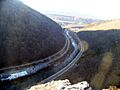
The Cumberland Narrows west of Cumberland, Maryland, along Wills Creek, with Haystack Mountain on the left and Wills Mountain on the right. The Western Maryland Scenic Railroad (left), Alternate U.S. 40, the Old National Road (center, left of the creek), and the CSX Railroad (right) can be seen in the foreground.
|
|
| Elevation | 620 ft (189 m) |
| Traversed by | U.S. Route 40, the National Road |
| Location | Allegany County, Maryland, U.S. |
| Range | Ridge-and-Valley Appalachians |
| Coordinates | 39°40′05″N 78°47′07″W / 39.668075°N 78.785276°W |
| Topo map | USGS Cumberland |
The Cumberland Narrows (also called "The Narrows") is a special natural opening in the mountains of western Maryland, in the United States. It's located just west of the city of Cumberland. Here, a stream called Wills Creek has cut its way through a large mountain ridge. This ridge is made up of Wills Mountain to the north and Haystack Mountain to the south.
You can see tall cliffs and piles of rocks from these mountains. These rocks are made of very strong Tuscarora quartzite. A famous rocky spot on the south end of Wills Mountain in the Narrows is known as Lover's Leap. The Narrows creates a beautiful mountain backdrop for the city of Cumberland.
Contents
Exploring the Cumberland Narrows

The Cumberland Narrows acts like a natural "doorway" from Cumberland to the lands further west. Beyond this gap are the Appalachian Plateau and the Ohio River Valley.
Many important paths and routes have passed through the Narrows over time:
- Nemacolin's Path: This was an old Native American trail.
- Old National Road: This historic road was one of the first major improved highways in the United States.
- Alternate U.S. 40: Today, this modern road follows much of the Old National Road's path.
- Railroads: Important train lines, like the former Baltimore and Ohio Railroad (now part of the CSX system), also go through the Narrows.
- Western Maryland Scenic Railroad: A fun excursion train that uses a former railroad line.
- Great Allegheny Passage: A popular bike trail also runs through the Narrows.
Lover's Leap: A Scenic View
Lover's Leap is a famous rocky spot on Wills Mountain. It's on the northeast side of the Cumberland Narrows. This spot is about 1,652 feet (504 m) above sea level. It's made of uniquely shaped rocks that go all the way down to the highway below.
From Lover's Leap, you can enjoy one of the most popular views in the Allegheny Mountains. You can see the city of Cumberland, the highway, and the train tracks far below. In the distance, you can even see parts of Pennsylvania and West Virginia.
History of Industry in the Narrows
Over the years, the Cumberland Narrows has also been a place for businesses and industry.
- Wills Mountain Inn: In the early 1900s, there was a large hotel and resort called the Wills Mountain Inn. It had 46 rooms and offered great views of the Narrows. Sadly, it burned down in 1930.
- Artmor Plastics Corporation: Later, a factory called Artmor Plastics Corporation was located on the Wills Mountain side of the Narrows. This building used to be a textile factory during World War II. Artmor Plastics made things like plastic dishes and table tops for homes.
After Artmor Plastics closed, the building became a museum. It showed the life of Arthur Morgan, who started Artmor, and his amazing collection of art and history. After Arthur Morgan passed away, the building was no longer used. The southern part of the building was damaged by a fire in 2015.
Images for kids
-
The Cumberland Narrows west of Cumberland, Maryland, along Wills Creek, with Haystack Mountain on the left and Wills Mountain on the right. The Western Maryland Scenic Railroad (left), Alternate U.S. 40, the Old National Road (center, left of the creek), and the CSX Railroad (right) can be seen in the foreground.
-

An oblique air photo of the Cumberland Narrows, facing northeast, December 2006
