
Hudson Highlands facts for kids
The Hudson Highlands are a beautiful group of mountains in New York state. They stand on both sides of the famous Hudson River. These mountains are mostly found in Putnam County on the east side of the river. On the west side, they are mainly in Orange County. Some parts also reach into Westchester County and Rockland County to the south.
The Highlands stretch from Newburgh Bay in the north to Haverstraw Bay in the south. The Hudson River flows into this mountain area from the south near Dunderberg Mountain. From the north, it enters near Breakneck Ridge and Storm King Mountain. These mountains have played a big part in America's history. They are important for military events, culture, and protecting nature.

Contents
How the Hudson Highlands Were Formed
The rocks that make up the Highlands are super old! They are over a billion years old. These rocks formed during a time when huge mountains were created. This event is called the Grenville Orogeny.
These rocks are the very heart of the Appalachian Mountains. The Appalachians were built up over many, many years. Different mountain-building events shaped them. Today's mountains became visible because of a slow process called isostasy. This happened over a long time, during the Cenozoic Era.
Giant glaciers helped shape the rounded hills we see today. The Highlands are some of the lowest peaks in the Appalachian range. The Appalachian Trail even reaches its lowest point here. This spot is in the Trailside Zoo, between Bear Mountain State Park and the Bear Mountain Bridge.
The Hudson River itself gets narrower and deeper as it flows through the Highlands. Its deepest point is 216 feet (66 meters) near Garrison. Many parts of the river here are tricky to sail through. Some sailors even call them "World's End."
History of the Hudson Highlands
Before Europeans arrived, the Hudson Highlands were home to the Lenape people. They were Native Americans. In 1609, Henry Hudson and his crew on the Half Moon were the first Europeans to explore the river. They were amazed by the Highlands.
The Highlands During the Revolutionary War
The mountains became very important during the American Revolutionary War. It was vital for the American army to control the Hudson River valley. This would stop the British from cutting off New England from the other colonies.
To block British ships, a huge Hudson River Chain was made. It was forged at an iron works in Orange County, New York. From 1778 to 1782, this chain was stretched across the river. It went from Fort Clinton at West Point. Today, this fort site is part of the United States Military Academy.

Art and Nature Protection
Years after America became independent, an artist named Thomas Cole started a new art movement. He painted America's wild and rugged landscapes. He especially loved the Highlands. His paintings showed raw nature with strong contrasts and shadows. This art style suggested a world being reborn.
Later, a critic jokingly called this movement the Hudson River School. The name stuck! It became the label for America's first homegrown art movement.
In the early 1900s, people started to worry about the Highlands. Quarrymen and loggers were causing damage. Local conservationists began to push for the government to own these woods and mountains. Their hard work paid off. Several state parks were created in the Highlands.
Later in the 20th century, there was a big plan to build a power plant. It would have dug into Storm King Mountain. But environmental groups fought back. They filed a landmark lawsuit. The judge made a historic decision. He ruled that the beauty of nature was important. He also said that groups of citizens could legally challenge big projects. This important lawsuit helped create many environmental protection laws.
Mountains of the Hudson Highlands
Here are some of the mountains in the Hudson Highlands:
East Side (from north to south)
- Sour Mountain
- Beacon Mountain (North and South)
- Scofield Ridge (the highest point in Putnam County)
- Sugarloaf Mountain
- Breakneck Ridge
- Bull Hill (also called Mt. Taurus)
- South Redoubt and North Redoubt (also called Fort Hill)
- Bald Hill
- Lamb's Hill
- Lamb's Hill West
- Sunset Point
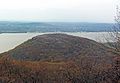
- Sugarloaf Hill
- White Rock
- Canada Hill
- Shenendoah Mountain
- Anthony's Nose
West Side (from north to south)
- Storm King Mountain
- Black Rock
- Crow's Nest
- Popolopen Torne
- Bear Mountain
- West Mountain
- Bald Mountain
- Spy Rock
- Eagles Cliff
- Dunderberg Mountain
- Long Mountain
- Sutherland Ridge
- Stillman Hill
- Arthur Hill
- Chatfield Hill
- Buckberg
Protected Areas of the Hudson Highlands
Many parts of the Hudson Highlands are protected as parks and forests. This helps keep them beautiful for everyone to enjoy.
- Bear Mountain State Park
- Black Rock Forest
- Harriman State Park
- Hudson Highlands State Park
- Manitoga
- Sterling Forest State Park
- Storm King State Park
Images for kids
-
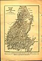
Highlands of the Hudson Forest Reservation in 1909
-
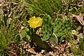
Opuntia humifusa (Eastern prickly pear cactus) blooming on Sugarloaf Hill
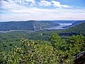
-
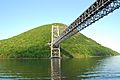
View from Hudson River with Bear Mountain Bridge in the foreground
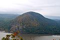
-
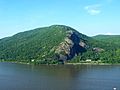
Breakneck Ridge seen from across the Hudson River
-
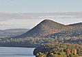
Sugarloaf Hill on the east bank of the river
-
Looking east from Popolopen Torne, with Bear Mountain Bridge across the Hudson River
-
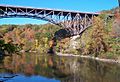
Popolopen Bridge on US Route 9W
-
Storm King and New York State Route 218 as seen from atop Breakneck Ridge
-
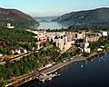
Central campus of West Point looking north
-
Sugarloaf Mountain from the Breakneck Bypass Trail


