
Storm King Mountain (New York) facts for kids
Quick facts for kids Storm King Mountain |
|
|---|---|

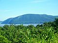
Storm King and New York State Route 218 as seen from atop Breakneck Ridge
|
|
| Highest point | |
| Elevation |
|
| Prominence | 100 ft (30 m) |
| Geography | |

Storm King Mountain
Location in New York

Storm King Mountain
Location in the United States
|
|
| Parent range | Hudson Highlands |
| Topo map | USGS West Point |
| Climbing | |
| Easiest route | Trail hike |
Storm King Mountain is a beautiful mountain in New York. It sits on the west side of the Hudson River, just south of Cornwall-on-Hudson, New York.
This mountain, along with Breakneck Ridge on the other side of the river, creates a special narrow passage. This passage is called "Wey-Gat," which means "Wind Gate." It's a very scenic part of the Hudson Highlands.
Storm King Mountain has a unique curved shape. You can easily spot it when looking south from places like Newburgh or Beacon. Drivers on the New York State Thruway can also see it. This view was a favorite for early artists of the Hudson River School.
Many people think Storm King Mountain is the tallest peak in the area. Its top reaches about 1,340 feet (408 meters) above sea level. However, a nearby eastern peak called Butter Hill is actually taller. Butter Hill is about 1,380 feet (421 meters) high.
What's in a Name?

When Henry Hudson first explored the river, his crew named the mountain Klinkesberg. This name came from its wrinkled rock cliffs near the water.
Later, early Dutch settlers in the area called it "Boterberg." This means "Butter Hill" because the mountain looked like a lump of butter. This English name, Butter Hill, became common for a while.
In the mid-1800s, a writer named Nathaniel Parker Willis lived nearby. He suggested the name Storm King. He noticed that when white clouds covered the mountain in the morning, it often meant a rainstorm was coming. He felt the mountain was like a king ordering the weather. So, he thought "Storm King" was a perfect name.
The road that winds around the mountain's eastern side, overlooking the Hudson River, was first called the Storm King Highway. Today, that name is often used for a wider road, U.S. Route 9W, to the west. The original road is now often called the Old Storm King Highway.
A Mountain's History

In 1962, Storm King Mountain became famous for an important environmental fight. A group of local people formed the Scenic Hudson Preservation Coalition. This group, now called Scenic Hudson, fought against a plan by Consolidated Edison. The company wanted to build a large power plant on the mountain. This plant would have cut away part of the mountain and created a big reservoir.
The environmental group took the company to court. For the first time ever, a judge ruled that environmental groups had the right to challenge government decisions in court. This was a huge step for environmental protection. In 1979, Con Edison finally gave up its plans for the power plant. They also agreed to protect fish in the Hudson River and gave $12 million to the Hudson River Foundation.
In 1999, there were forest fires on the mountain during a dry summer. After the fires, old, unexploded bombs were found. These were left over from 19th-century artillery tests by the nearby West Point military academy. Because of this, hiking on the mountain was stopped until October 2002. Authorities needed to make sure all dangerous items were safely removed.
On February 20, 2011, a NYPD helicopter rescued two students from West Point. They had gotten stuck while rappelling down a cliff face. A New York State Police helicopter could not complete the rescue, so the NYPD stepped in.
Hiking and Exploring
Storm King Mountain is a big part of Storm King State Park. Both Storm King and Butter Hill summits offer amazing views of the river and surrounding areas. This makes them very popular with hikers.
A common hiking path starts from a parking area on U.S. Route 9W. An orange-marked trail leads to the yellow-marked Stillman Trail. This path gives you a quick, steep climb up Butter Hill. After that, it's a longer, more relaxing hike to the top of Storm King.
While not often done or allowed by park rules, there are some challenging rock climbing routes above the river. When the weather is right, people also go ice climbing here.
Images for kids
-
Storm King and Butter Hill from Newburgh, New York
-
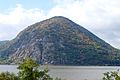
Seen looking west from the base of Breakneck Ridge
-
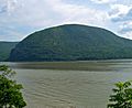
Storm King from the Breakneck Ridge train station across the Hudson River


