
Decatur, Alabama facts for kids
Quick facts for kids
Decatur, Alabama
|
|||
|---|---|---|---|
.jpg)
Downtown viewed from 2nd street
|
|||
|
|||
| Nickname(s):
The River City, The Chicago of the South, The Heart of the Valley
|
|||
| Motto(s):
"The City of Opportunity"
|
|||

Location in Limestone County and Morgan County, Alabama
|
|||
| Country | United States | ||
| State | Alabama | ||
| Counties | Morgan, Limestone | ||
| Founded | June 16, 1820 | ||
| Incorporated | December 8, 1826 | ||
| Incorporated | January 11, 1834 | ||
| Government | |||
| • Type | Mayoral-Council | ||
| Area | |||
| • City | 61.020 sq mi (158.041 km2) | ||
| • Land | 54.594 sq mi (141.398 km2) | ||
| • Water | 6.426 sq mi (16.643 km2) | ||
| Elevation | 594 ft (181 m) | ||
| Population
(2020)
|
|||
| • City | 57,938 | ||
| • Estimate
(2022)
|
57,922 | ||
| • Rank | US: 682nd AL: 10th |
||
| • Density | 1,061/sq mi (409.6/km2) | ||
| • Urban | 60,458 (US: 449th) | ||
| • Urban density | 1,390.8/sq mi (537.0/km2) | ||
| • Metro | 157,425 (US: 272nd) | ||
| • Metro density | 123.9/sq mi (47.85/km2) | ||
| • Combined | 879,315 (US: 68th) | ||
| • Combined density | 255.3/sq mi (98.57/km2) | ||
| Time zone | UTC−6 (Central (CST)) | ||
| • Summer (DST) | UTC−5 (CDT) | ||
| ZIP Codes |
35601, 35602, 35603, 35609, 35699
|
||
| Area code(s) | 256 and 938 | ||
| FIPS code | 01-20104 | ||
| GNIS feature ID | 2404206 | ||


Decatur (/dɪˈkeɪtər/) is a city in Alabama, located in the northern part of the state. It is the largest city in Morgan County, and a small part of it is also in Limestone County. People often call it "The River City" because it sits right on the banks of Wheeler Lake along the Tennessee River.
In 2020, about 57,938 people lived in Decatur. It's the main city of the Decatur metropolitan area, which had an estimated population of 157,425 in 2022. When combined with the Huntsville Metropolitan Area, Decatur becomes the second-largest city in the larger Huntsville-Decatur Combined Statistical Area.
Long ago, Decatur grew quickly because of its great location on the river. It became a busy spot for boats and trains, connecting important cities like Nashville and Mobile. Today, Decatur's economy relies heavily on manufacturing, mining, shipping goods, and high-tech companies. Some big companies here include Vulcan Materials, Daikin, Toray, and United Launch Alliance.
Contents
History of Decatur, Alabama
How Decatur Got Started
The area where Decatur is now was first known as "Rhodes Ferry Landing." This name came from Dr. Henry W. Rhodes, who ran a ferry across the Tennessee River in the 1810s. The city was officially named Decatur in 1821. It was named after Stephen Decatur, a naval hero, after he passed away in 1820.
In the early 1830s, Decatur became important for railroads. It was the eastern end of the Tuscumbia, Courtland and Decatur Railroad, which was the first railway built west of the Appalachian Mountains. Later, in 1850, this railway became part of the larger Memphis & Charleston Railroad.
Decatur During the Civil War
Because of its location on the Tennessee River and its important railroad crossings, Decatur saw many events during the American Civil War. When the Union Army took control of the city early in the war, most buildings were destroyed. Only three buildings remained standing: the Old State Bank, the Dancy-Polk House, and the Burleson-Hinds-McEntire House.
Later, in 1864, a Confederate army tried to take the city back during the Battle of Decatur. The city was very difficult to capture, earning it the nickname "A Tough Nut to Crack." Plans for the Battle of Shiloh were even made in the Burleson-Hinds-McEntire House, making it a very historic spot.
Merging Two Cities: Decatur and Albany
After the Civil War, a new city called "New Decatur" grew up next to the old Decatur, west of the railroad tracks. New Decatur was founded in 1887. People from the older Decatur didn't always get along with the newcomers. To show their independence, New Decatur changed its name to "Albany" in 1916, named after Albany, New York.
However, the two towns realized they needed to work together, especially to build a bridge across the Tennessee River instead of just a ferry. In 1925, the two cities officially merged to become one City of Decatur. Even today, you can see differences between the eastern and western parts of town, reflecting their separate beginnings.
Historic Landmarks and Firsts
The Old State Bank in downtown Decatur is the oldest bank building in Alabama, being 190 years old. Decatur is also home to the first wave pool in the United States, which is still open at the Point Mallard Aquatic Center. The city also has the largest district of Victorian-era homes in Alabama.
Geography and Climate
Where is Decatur Located?
Decatur is mainly in Morgan County, with a small part extending into Limestone County across the Tennessee River. Key waterways in the city include Wheeler Lake on the Tennessee River, along with Flint Creek and Dry Branch.
The northern part of Decatur sits on a hill overlooking the Tennessee River. This hill helps the "Steamboat Bill" Memorial Bridge cross the river easily, without getting in the way of the busy barge traffic below. South of this hill, the land is mostly flat.
Decatur covers about 61 square miles (158 square kilometers), with most of that being land. It is about 25 miles (40 km) southwest of Huntsville and 86 miles (138 km) north of Birmingham.
Decatur's Weather (Climate)
Decatur has a humid subtropical climate, which means it has four clear seasons.
- Winters are usually mild, with an average temperature of about 40.6°F (4.8°C) in January. It doesn't snow much, but you might see a small amount a few times a year.
- Summers are hot and humid, with an average temperature of about 79.6°F (26.4°C) in July. It often gets above 90°F (32°C). Thunderstorms are common in summer.
- Spring and Autumn have pleasant temperatures and some rain.
Decatur gets about 53.4 inches (135.6 cm) of rain each year. Severe thunderstorms can happen, especially in spring and November, bringing strong winds and sometimes tornadoes. The highest temperature ever recorded was 108°F (42°C), and the lowest was -19°F (-28°C).
| Climate data for Decatur, Alabama (1991–2020 normals) | |||||||||||||
|---|---|---|---|---|---|---|---|---|---|---|---|---|---|
| Month | Jan | Feb | Mar | Apr | May | Jun | Jul | Aug | Sep | Oct | Nov | Dec | Year |
| Record high °F (°C) | 78 (26) |
82 (28) |
87 (31) |
94 (34) |
99 (37) |
105 (41) |
108 (42) |
108 (42) |
105 (41) |
97 (36) |
86 (30) |
80 (27) |
108 (42) |
| Mean daily maximum °F (°C) | 50.7 (10.4) |
55.4 (13.0) |
63.7 (17.6) |
73.0 (22.8) |
80.8 (27.1) |
87.6 (30.9) |
89.8 (32.1) |
89.8 (32.1) |
85.1 (29.5) |
74.5 (23.6) |
62.3 (16.8) |
53.6 (12.0) |
72.2 (22.3) |
| Daily mean °F (°C) | 41.4 (5.2) |
45.3 (7.4) |
52.7 (11.5) |
61.6 (16.4) |
69.9 (21.1) |
77.1 (25.1) |
79.7 (26.5) |
78.8 (26.0) |
73.1 (22.8) |
62.0 (16.7) |
50.8 (10.4) |
44.1 (6.7) |
61.4 (16.3) |
| Mean daily minimum °F (°C) | 32.0 (0.0) |
35.2 (1.8) |
41.7 (5.4) |
50.1 (10.1) |
59.1 (15.1) |
66.6 (19.2) |
69.7 (20.9) |
67.9 (19.9) |
61.2 (16.2) |
49.5 (9.7) |
39.2 (4.0) |
34.6 (1.4) |
50.6 (10.3) |
| Record low °F (°C) | −19 (−28) |
−4 (−20) |
7 (−14) |
20 (−7) |
35 (2) |
42 (6) |
51 (11) |
50 (10) |
36 (2) |
24 (−4) |
0 (−18) |
−5 (−21) |
−19 (−28) |
| Average precipitation inches (mm) | 4.64 (118) |
4.96 (126) |
4.96 (126) |
4.50 (114) |
4.15 (105) |
3.66 (93) |
3.95 (100) |
3.05 (77) |
3.21 (82) |
3.23 (82) |
3.96 (101) |
5.20 (132) |
49.47 (1,257) |
| Average precipitation days (≥ 0.01 in) | 9.3 | 12.1 | 11.0 | 11.0 | 10.8 | 11.4 | 12.4 | 10.6 | 8.3 | 8.6 | 9.7 | 10.8 | 126.0 |
| Source 1: NOAA | |||||||||||||
| Source 2: The Weather Channel (extremes) | |||||||||||||
Nearby Cities and Towns
Decatur is close to several other cities and towns:
- Athens (north)
- Hartselle (south)
- Hillsboro (west)
- Huntsville (northeast)
- Madison (northeast)
- Mooresville (northeast)
- Moulton (southwest)
- Priceville (east)
- Trinity (west)
Decatur's Neighborhoods
Decatur is split into four main areas: Northeast, Southeast, Northwest, and Southwest. The CSX Railroad tracks divide the city, and Moulton Street also helps separate the areas. You can notice small differences in how the streets are laid out and the styles of buildings between the East and West sides of town.
Northwest
- West Decatur (north of Moulton Street)
Northeast
- Albany (New Decatur)
- Downtown Decatur
- East Acres
- Old Decatur
- Bank Street and Second Avenue (Downtown Shopping District)
- Harborview (Riverfront)
- Irvington (Limestone County)
- Whiteside (Limestone County)
Southeast
- Bayside
- Brookmeade
- Burleson Mountain
- Burningtree Mountain
- Cedar Lake
- Fairview
- Flint
- Hickory Hills
- Indian Hills
- Point Mallard Estates
Southwest
- Autumn Ridge
- Austinville
- Basham
- Braswell
- Cedar Ridge
- Chapel Hill
- Chula Vista
- City View Estates
- Deerfoot Estates
- Dogwood Estates
- Dunbarton
- Flint
- Graystone
- Griffin Addition
- Longleaf Estates
- Moulton Heights
- Oak Lea
- Oakworth
- Timberlake
- Russell Village
- Vestavia
- West Decatur (south of Moulton Street)
- Westmeade
- Woodtrail
Population and People
| Historical population | |||
|---|---|---|---|
| Census | Pop. | %± | |
| 1850 | 606 | — | |
| 1870 | 671 | — | |
| 1880 | 1,063 | 58.4% | |
| 1890 | 2,765 | 160.1% | |
| 1900 | 3,114 | 12.6% | |
| 1910 | 4,228 | 35.8% | |
| 1920 | 4,752 | 12.4% | |
| 1930 | 15,593 | 228.1% | |
| 1940 | 16,604 | 6.5% | |
| 1950 | 19,974 | 20.3% | |
| 1960 | 29,217 | 46.3% | |
| 1970 | 38,044 | 30.2% | |
| 1980 | 42,002 | 10.4% | |
| 1990 | 48,761 | 16.1% | |
| 2000 | 53,929 | 10.6% | |
| 2010 | 55,683 | 3.3% | |
| 2020 | 57,938 | 4.0% | |
| 2022 (est.) | 57,922 | 4.0% | |
| U.S. Decennial Census 2020 Census |
|||
Decatur's Population in 2020
In 2020, Decatur had 57,938 people living in 23,570 households. About 14,864 of these were families. There were also 25,351 housing units in the city.
| Race | Number | Percent |
|---|---|---|
| White (non-Hispanic) | 32,079 | 55.37% |
| Black or African American (non-Hispanic) | 13,314 | 22.98% |
| Native American | 207 | 0.36% |
| Asian | 518 | 0.89% |
| Pacific Islander | 54 | 0.09% |
| Other/Mixed | 2,696 | 4.65% |
| Hispanic or Latino | 9,070 | 15.65% |
Decatur's Population in 2010
In 2010, there were 55,683 people in Decatur. The city had 22,576 households, with 14,918 of them being families.
- About 28.7% of households had children under 18.
- 46.0% were married couples.
- 15.6% had a female head of household with no husband present.
- The average household had 2.42 people, and the average family had 2.99 people.
The population was spread out by age:
- 24.1% were under 18.
- 9.0% were 18 to 24.
- 26.1% were 25 to 44.
- 26.3% were 45 to 64.
- 14.5% were 65 or older.
The average age was 37.9 years.
The median income for a household was $43,090, and for a family it was $55,158. About 17.5% of the population lived below the poverty line.
Economy and Jobs
Decatur is a very busy place for shipping goods by river. The Port of Decatur handles a lot of barge traffic on the Tennessee River. This has led many large companies to open factories here. Some major employers include General Electric, 3M, Wayne Farms, United Launch Alliance, Nucor, Bunge Limited, Daikin, Hyosung, Ascend Performance Materials, and the Tennessee Valley Authority.
Decatur is also known as the "Home of Meow Mix" cat food! The company has a large facility here and uses the river to ship its products.
The area around Decatur and Huntsville has a lot of engineers, more than most places in the country. This is because of the many high-tech companies and research centers nearby.

The United Launch Alliance (ULA) plant in Decatur builds all the satellite launching rockets used by the U.S. government. This brought many new jobs to the city. ULA uses the Tennessee River to ship these huge rockets to places like Cape Canaveral for launch.
Fun Things to Do (Tourism)
Tourism is a big part of Decatur's economy, with many people visiting for its exciting festivals.
Popular Festivals and Events
- Alabama Jubilee: Started in 1978, this is the oldest hot air balloon race in the South. Over 100,000 people come to watch more than 60 huge balloons inflate and take off. Because of this event, Decatur is called "The Ballooning Capital of Alabama."
- Spirit of America Festival: This is one of the biggest free Fourth of July celebrations in the South. More than 65,000 people come to enjoy the festivities and watch the Miss Spirit of America beauty pageant.
- Racking Horse World Celebration: This event brings horses from all over the world to compete in the largest Racking Horse competition. It attracts up to 75,000 fans and competitors each year.
- Riverfest Barbeque Cook-off: Held at Ingalls Harbor, this competition brings barbecue chefs from across the country. Visitors can enjoy live music, activities for kids, and amazing barbecue. The money raised helps local charities.
Cook Museum of Natural Science
The Cook Museum of Natural Science opened in 2018. It's a modern museum that shows off many local animals and plants. It was even nominated by USA Today as one of the best new museums to open in recent years!
Parks and Recreation

Delano Park is a beautiful 28-acre park founded in 1887. It's the oldest city park in Morgan County that has been open continuously. It's a historic landscape and is listed on the National Historic Register.
Education in Decatur
Decatur has two main public high schools: Austin High and Decatur High. Both schools offer the International Baccalaureate Program, which is an advanced honors program for older students. This makes Decatur one of the few school systems in Alabama to offer it.
Public Schools
High Schools
- Austin High School
- Decatur High School
Middle Schools
- Decatur Middle School
- Austin Middle School
- Austin Junior High
Private Schools
- Decatur Heritage Christian Academy
- Cornerstone Christian School (Kindergarten to 12th grade)
- St. Ann's Catholic School (Kindergarten to 8th grade)
Colleges and Universities
- Alabama Center for the Arts
- Calhoun Community College System
- Strayer University
Media and News
Newspapers
The Decatur Daily has been the main newspaper in the Decatur area since 1912. It's one of the few family-owned newspapers in Alabama. It delivers news to Morgan, Lawrence, Limestone, and parts of Cullman and Winston counties.
The Huntsville Times is another newspaper that covers the larger Huntsville-Decatur area.
Cable and Phone Services
Companies like Spectrum, AT&T, and WOW! offer cable TV and phone services in Decatur. AT&T has also started rolling out its fiber internet network in the city.
Getting Around (Transportation)
By Air (Airports)
Decatur is served by two main airports:
- The Huntsville International Airport, which is the second busiest airport in Alabama.
- The Pryor Field Regional Airport, which is the busiest regional airport in Alabama.
By Road (Highways)

Decatur's main roads include U.S. Route 31 (also called 6th Avenue), U.S. Route 72 Alternate, State Route 24, and State Route 67. The "Steamboat Bill" Hudson Memorial Bridge carries U.S. 72 Alternate and U.S. 31 across the Tennessee River.
Interstate 65 runs east of the city, connecting it to Nashville in the north and Birmingham in the south. Interstate 565 starts northeast of Decatur and goes to Huntsville.
Major Highways
 Interstate 65
 Interstate 565
 U.S. Highway 31
 U.S. Highway 72 Alternate
 SR 20
SR 20 SR 24
SR 24 SR 67
SR 67
By Water (River)
Large shipments can travel from Decatur all the way to the Atlantic Ocean by using the Tennessee River, then the Mississippi River, and finally the Gulf of Mexico. This route is even used to ship parts of space launch vehicles built by United Launch Alliance in Decatur to launch sites like Cape Canaveral.
By Rail (Trains)
Decatur has two major railroads: the Norfolk Southern Railway and CSX Transportation (CSX). CSX has a train yard downtown. The old Decatur Union Depot used to be a busy train station for passenger trains, but now it's a museum.
Local Transit
The NARCOG Transit offers on-demand bus services in the city, meaning you can call to arrange a ride. There are no regular bus routes that run on a fixed schedule.
Healthcare and Hospitals
Decatur has two hospitals: Decatur General Hospital and Parkway Medical Center.
- Decatur General Hospital is a large hospital with 273 beds for general care and 64 beds for behavioral medicine. It is a level two trauma center, meaning it can handle serious injuries.
- Parkway Medical Center has 120 beds and is a level three trauma center. Since 2012, it has been owned by Huntsville Hospital, which is the main referral center and level one trauma center for North Alabama.
Famous People from Decatur
Many notable people have come from Decatur, Alabama!
- Joseph Abbott, U.S. congressman
- Richard W. Austin, U.S. congressman
- Cynthia Bailey, model (from Real Housewives of Atlanta)
- Loren C. Ball, astronomer who discovered an asteroid named after Decatur
- Taye Biddle, professional football player
- Lucas Black, actor
- Alonzo Boone, Negro League baseball pitcher and manager
- Marv Breeding, Major League baseball player
- Cedrick Bridgeforth, Methodist bishop
- Deonte Brown, former University of Alabama football player
- Anna Laura Bryan, Miss Alabama 2012
- Rufus Columbus Burleson, Baptist preacher and university president
- Charlie Burse, blues musician
- Kendrick Burton, professional football player
- Jason Carthen, professional football player and public speaker
- David Charles, neurologist
- Grace Curzon, Marchioness Curzon of Kedleston, wife of a Viceroy of India
- Pop Gates, professional basketball player and Harlem Globetrotter
- Chad Girodo, Major League baseball pitcher
- Eugene C. Gordon, founder of a local company
- Christopher Columbus Harris, U.S. congressman
- Robin Henderson, associate director at NASA Marshall Space Flight Center
- Richard Hendrix, professional basketball player
- Mae Jemison, the first African American woman in space
- Dean Jones, actor
- Leslie Kelley, former New Orleans Saints football player
- Seth Kimbrough, professional BMX rider
- Gary Knotts, Major League baseball pitcher
- Alan Koch, Major League baseball pitcher
- Cricket Lee, entrepreneur and inventor
- Donald Lourie, College Football Hall of Fame quarterback and former president of Quaker Oats Company
- Seybourn Harris Lynne, federal judge
- Rolando McClain, National Football League football player
- Chuck Murphy, American Anglican bishop
- Arthur Orr, member of the Alabama Senate
- John O'Sullivan, columnist and pundit
- Luther Patrick, U.S. congressman
- Josh Pearson, football wide receiver and Super Bowl champion
- Ray Pepper, Major League Baseball outfielder
- Bennie Perrin, former St. Louis Cardinals football player
- Charles Redding Pitt, U.S. Attorney and politician
- Jerraud Powers, National Football League football player
- Andy Price, comic artist
- Gary Redus, Major League baseball outfielder
- Kristopher Reisz, novelist
- Philip Rivers, National Football League quarterback
- Johnny Sandlin, musician, recording engineer, record producer
- Rip Sewell, Major League baseball pitcher
- Charles Christopher Sheats, U.S. congressman
- Perry Stephens, actor and singer
- Mandisa Stevenson, professional basketball player
- David Stewart, former Tennessee Titans football player
- Skip Stewart, aerobatic pilot
- Travis S. Taylor, aerospace engineer
- Gordon Terry, bluegrass and country music musician
- Randy Thornhill, entomologist and evolutionary biologist
- Carson Tinker, long snapper for the Los Angeles Rams
- Judith Toups, birder and columnist
- Phil Waldrep, Southern Baptist preacher and minister
- Don Whitmire, College Football Hall of Fame football player
- Mildred Wolfe, artist
Images for kids
-
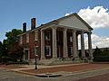
The historic Old State Bank building in Decatur.
-
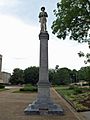
A statue at the Morgan County Courthouse in Decatur.
-

Hot air balloons inflating at the 1990 Alabama Jubilee Hot Air Balloon Classic.


See also
 In Spanish: Decatur (Alabama) para niños
