Tornado facts for kids
Quick facts for kids Tornado |
|
|---|---|
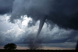
An F3 tornado near Anadarko, Oklahoma, 1999.
|
|
| Season | Primarily spring and summer, but can be at any time of year |
| Effect | Wind damage |
A tornado is a powerful tube of spinning air that touches the ground. The wind inside a tornado spins incredibly fast, making these storms very dangerous. They are especially risky for people in cars or mobile homes. About 60 people die from tornadoes each year.
The word tornado comes from the Spanish word tornado, which means 'to turn' or 'to have turned'. This word itself comes from the Latin word tonare, meaning 'to thunder'.
Tornadoes can destroy many things. They can tear houses apart and often leave people without a home. Even though they are smaller than hurricanes, tornadoes are much stronger. Almost three-quarters of the world's tornadoes happen in the United States. However, they can form almost anywhere.
Tornadoes cause a lot of damage to anything in their path. Scientists use the Enhanced Fujita scale to rank tornadoes, from EF0 (least damage) to EF5 (most damage).
Tornadoes can happen in nearly every part of the world. In the United States, every state has experienced a tornado. The central part of the United States is even called 'Tornado Alley' because so many tornadoes happen there. A tornado's winds can spin faster than 300 miles per hour (480 km/h)!
Most tornadoes have wind speeds less than 110 miles per hour (180 km/h). They are usually about 250 feet (80 m) wide and travel only a few miles before they disappear. Other spinning air events in nature include dust devils and fire whirls.
Weather experts issue a "tornado watch" when conditions are right for a tornado to form. A "tornado warning" means a tornado has actually been seen or detected on weather radar. A "tornado emergency" is a very serious warning. It means a powerful tornado is about to hit a crowded area, or one has been spotted and is expected to cause deaths.
Contents
What Do Tornadoes Look Like?
Size and Shape of Tornadoes
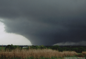
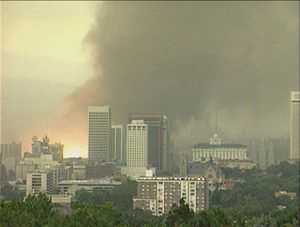
Most tornadoes look like a narrow funnel cloud. They are usually a few hundred meters (yards) wide. Sometimes, a tornado can be hidden completely by rain or dust. These hidden tornadoes are very dangerous because even experienced weather experts might not see them.
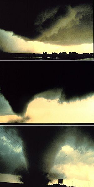
Small, weaker tornadoes might only look like a small swirl of dust on the ground. If the winds at the surface are stronger than 40 mph (64 km/h), it's considered a tornado. Some tornadoes have a nearly straight, cylindrical shape and are called "stovepipe" tornadoes. Very large tornadoes can look like huge wedges stuck into the ground. These are known as "wedge tornadoes." A wedge tornado can be so wide that it looks like a block of dark clouds. It can be hard to tell the difference between a low cloud and a wedge tornado from far away. Many of the strongest tornadoes are wedges.
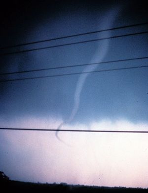
When tornadoes start to disappear, they can look like narrow tubes or ropes. They often curl or twist into strange shapes. This is called "roping out." As they rope out, their funnel gets longer, which makes the winds inside weaker. Sometimes, a tornado can have several smaller spinning columns of air inside it. These are called multiple-vortex tornadoes.
In the United States, tornadoes are about 500 feet (150 m) wide on average. But their sizes can vary a lot. Weak or disappearing tornadoes can be very narrow, sometimes just a few feet (meters) across. One tornado was only 7 feet (2 m) long! On the other hand, some wedge tornadoes can be a mile (1.6 km) wide or more. The widest tornado ever recorded was in El Reno, Oklahoma, in 2013. It was about 2.6 miles (4.2 km) wide!
How Far Do Tornadoes Travel?
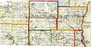
In the United States, the average tornado travels about 5 miles (8 km) on the ground. However, some tornadoes travel much shorter or much longer distances. One tornado was only 7 feet (2 m) long. The longest-traveling tornado ever was the Tri-State Tornado in 1925. It stayed on the ground for 219 miles (352 km) across parts of Missouri, Illinois, and Indiana! Many tornadoes that seem to travel 100 miles (160 km) or more are actually a series of tornadoes that formed one after another.
What Colors Are Tornadoes?
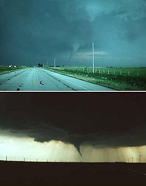
Tornadoes can be many different colors, depending on where they form. Tornadoes in dry areas might be almost invisible, only showing swirling dust at their base. Funnels that pick up little debris can be gray or white. Over water, they can turn white or even blue. Slow-moving tornadoes that pick up a lot of dirt and debris are usually darker. They take on the color of the dirt. Tornadoes in the Great Plains can look red because of the reddish soil. Tornadoes in mountains can travel over snow, making them look white.
How the sun hits the tornado also changes its color. A tornado with the sun behind it (back-lit) looks very dark. The same tornado, with the sun behind you, might look gray or bright white. Tornadoes that happen near sunset can be yellow, orange, or pink.
Dust, heavy rain, hail, and the darkness of night can make tornadoes hard to see. Tornadoes in these conditions are extra dangerous. Often, the only warning is from weather radar or the sound of the approaching tornado. Most strong tornadoes form under the storm's rain-free area, so they are usually visible. Also, most tornadoes happen in the late afternoon when the sun is bright.
Some people who have been inside a tornado say it has a clear, calm center, like the eye of a hurricane. They say lightning lights up the inside.
How Do Tornadoes Spin?
Tornadoes usually spin counterclockwise in the northern hemisphere (like a clock going backward). In the southern hemisphere, they spin clockwise.
What Sounds Do Tornadoes Make?
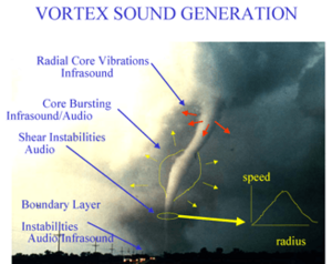
People have described tornado sounds in many ways. Some say it sounds like a freight train, rushing water, or a jet engine. Many tornadoes cannot be heard from far away. The sound and how far it travels depend on the air conditions and the land.
Since many tornadoes can only be heard when they are very close, sound is not a reliable way to warn people about a tornado.
How Do Tornadoes Form?
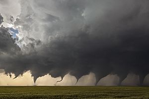
Most tornadoes form from a type of thunderstorm called a supercell. Supercells have a spinning area of air a few miles up in the atmosphere, called a mesocyclone. This spinning area is usually 1 to 6 miles (1.6 to 9.7 km) wide. Most strong tornadoes (EF3 to EF5) come from supercells. Besides tornadoes, supercells can bring very heavy rain, lots of lightning, strong wind gusts, and hail.
Most supercell tornadoes follow a pattern as they form and disappear.
The Beginning of a Tornado
The process starts when a strong thunderstorm develops a spinning mesocyclone high up in the atmosphere. As rain falls from the storm, it pulls down an area of quickly sinking air called the rear flank downdraft (RFD). This downdraft speeds up as it gets closer to the ground. It also pulls the supercell's spinning mesocyclone down towards the ground.
As the mesocyclone gets lower, it starts to pull in cool, moist air from the downdraft area of the storm. This mix of warm air (going up) and cool air (going down) creates a spinning wall cloud. The RFD also makes the mesocyclone's base smaller, pulling air from a smaller area on the ground. As the updraft (air going up) gets stronger, it creates an area of low pressure at the surface. This pulls the focused mesocyclone down, forming a visible funnel cloud. As the funnel comes down, the RFD also reaches the ground. This creates a strong gust of wind that can cause damage far from the tornado itself. Usually, the funnel cloud starts causing damage (becoming a tornado) within a few minutes of the RFD hitting the ground.
When a Tornado is Strongest
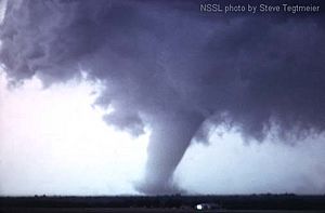
At first, the tornado has plenty of warm, moist air flowing into it to keep it going. It grows until it reaches its "mature stage." This stage can last from a few minutes to over an hour. During this time, a tornado often causes the most damage. In rare cases, it can be more than 1 mile (1.6 km) wide. The low pressure at the base of the tornado is very important for it to last. However, the RFD, which is now cool surface winds, starts to wrap around the tornado. This cuts off the warm air that was feeding the tornado.
The air inside the tornado's funnel flows downward, bringing water vapor from the cloud above. This is different from hurricanes, where the air flows upward, getting water vapor from the warm ocean below.
When a Tornado Disappears
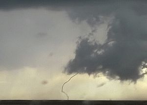
As the RFD completely wraps around and cuts off the tornado's air supply, the spinning air starts to weaken. It becomes thin and looks like a rope. This is the "dissipating stage," and it usually lasts only a few minutes before the tornado ends. During this stage, the tornado's shape is greatly affected by the winds of the main storm. It can be blown into amazing patterns. Even though the tornado is disappearing, it can still cause damage. The storm is shrinking into a rope-like tube, and because of how spinning objects work, the winds can actually get stronger at this point.
Sometimes, in very strong supercells, tornadoes can form in a cycle. As one tornado and its spinning area disappear, the storm's air might focus into a new area. This can create a new spinning area and possibly a new tornado. If a new spinning area forms, the cycle can start again, making one or more new tornadoes.
This is how most tornadoes form, live, and die. However, it doesn't explain how smaller tornadoes, like landspouts, or tornadoes with many spinning parts form. These have different ways of developing.
Different Kinds of Tornadoes
Multiple-Vortex Tornadoes
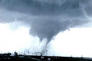
A multiple-vortex tornado is a tornado where two or more columns of spinning air rotate around their own centers. At the same time, they all revolve around a common center. This can happen in almost any spinning air system, but it's often seen in very strong tornadoes. These smaller spinning parts can create areas of even heavier damage along the main tornado's path. This is different from a satellite tornado, which is a smaller, separate tornado that forms very close to a large, strong tornado within the same storm. A satellite tornado might seem to "orbit" the larger tornado, but it's a distinct, smaller spinning system.
Waterspouts
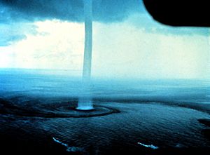
A waterspout is a tornado that forms over water. However, experts usually separate "fair weather" waterspouts from tornadic waterspouts. Fair weather waterspouts are less severe but much more common. They are similar to dust devils and landspouts. They form under cumulus clouds over warm, tropical waters. They have weaker winds, smooth sides, and usually move very slowly. They are most common in the Florida Keys and the northern Adriatic Sea.
In contrast, tornadic waterspouts are stronger tornadoes that form over water. They form in a similar way to tornadoes over land, or they are strong tornadoes that move from land over water. Since they come from severe thunderstorms and can be much stronger, faster, and last longer than fair weather waterspouts, they are more dangerous.
Landspouts
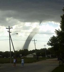
A landspout is a tornado that is not connected to a mesocyclone. The name comes from them being like a "fair weather waterspout on land." Waterspouts and landspouts share many features. They are usually weaker, don't last long, and have a small, smooth funnel cloud that often doesn't reach the ground. Landspouts also create a clear, smooth cloud of dust when they touch the ground. Even though they are usually weaker than classic tornadoes, they can still have strong winds that cause serious damage.
How Strong Are Tornadoes?
| F0 EF0 |
F1 EF1 |
F2 EF2 |
F3 EF3 |
F4 EF4 |
F5 EF5 |
|---|---|---|---|---|---|
| Weak | Strong | Violent | |||
| Significant | |||||
| Intense | |||||
The Fujita scale and the Enhanced Fujita Scale (EF Scale) rate tornadoes based on the damage they cause. The EF Scale is an updated version of the older Fujita scale. It was designed so that a tornado would get the same number rating on both scales. The United States started using the EF Scale in 2007. An EF0 tornado will likely damage trees but not strong buildings. An EF5 tornado can rip buildings off their foundations, leaving nothing behind. It can even twist large skyscrapers.
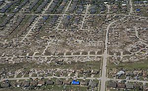
Tornadoes vary in strength no matter their shape, size, or location. However, strong tornadoes are usually larger than weak ones. Longer-lasting tornadoes also tend to be stronger. For very violent tornadoes, only a small part of their path has the highest intensity.
In the United States, 80% of tornadoes are EF0 and EF1. These are considered weak tornadoes.
Outside Tornado Alley and North America, very violent tornadoes are extremely rare. This is mainly because there are fewer tornadoes overall in those areas. However, research shows that the way tornadoes are distributed by strength is similar worldwide. A few strong tornadoes happen every year in Europe, Asia, southern Africa, and southeastern South America.
How Are Tornadoes Detected?
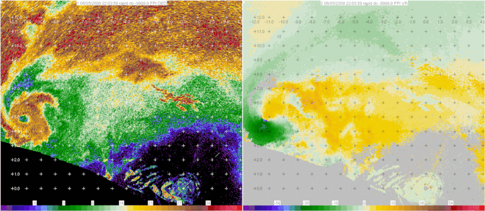
Serious efforts to warn people about tornadoes began in the United States in the mid-1900s. Before the 1950s, the only way to know about a tornado was if someone saw it on the ground. Often, news of a tornado would reach a local weather office after the storm had passed. But with the invention of weather radar, areas near a weather office could get early warnings about severe weather. The first public tornado warnings were given in 1950. In 1953, it was confirmed that "hook echoes" on radar were linked to tornadoes. By recognizing these radar shapes, meteorologists could spot thunderstorms that were likely producing tornadoes many miles away.
Using Radar to Find Tornadoes
Today, most developed countries have a network of weather radars. These radars are the main way to find hook shapes that likely mean a tornado is forming. In the United States and some other countries, Doppler weather radar stations are used. These devices measure how fast and in what direction winds are moving within a storm. This means they can see signs of spinning in storms from over 100 miles (160 km) away. When storms are far from the radar, only the higher parts of the storm are seen, and the important areas closer to the ground are not. Also, the radar's view becomes less clear the farther away it is. Sometimes, tornadoes can form faster than the radar can scan and send data. Doppler radar systems can detect mesocyclones inside a supercell thunderstorm. This helps meteorologists predict when tornadoes might form.
Storm Spotters
Many countries have volunteer storm spotters. These are people who are trained to look for severe weather, including tornadoes. They report what they see to weather organizations. These organizations then activate public warning systems like sirens and the Emergency Alert System (EAS). They also send the reports to the national weather service.
In the United States, there are over 230,000 trained Skywarn weather spotters. In Canada, there's a similar group called Canwarn with over 1,000 volunteers. In Europe, several countries are setting up spotter networks.
Storm spotters are important because radar systems like NEXRAD detect signs that suggest tornadoes, not the tornadoes themselves. Radar can give a warning before you can see a tornado. But a person on the ground can give definite information. A spotter's ability to see what radar cannot is especially important when the storm is far from the radar. This is because the radar beam gets higher in the sky and spreads out more the farther it travels, due to the Earth's curve.
What to Look for: Visual Clues
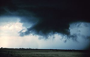
Storm spotters are trained to tell if a storm is a supercell from a distance. They usually look at the back of the storm, where the main updraft (air going up) is. Under that updraft, there's a rain-free area. The next step for a tornado to form is a spinning wall cloud. Most strong tornadoes happen with a wall cloud at the back of a supercell.
Signs of a supercell include the storm's shape and structure. Look for a strong updraft tower, a large cloud that shoots up above the main storm (overshooting top), and a firm anvil cloud (the flat top of the storm). The storm might also have a corkscrew look or stripes. Closer to where tornadoes form, signs of a supercell and a likely tornado include curved inflow bands (clouds flowing into the storm) and how strong and moist the air flowing into the storm is. Tornadoes are most likely to form where the updraft meets the rear flank downdraft.
Only wall clouds that spin will create tornadoes. They usually appear five to thirty minutes before a tornado. Spinning wall clouds can be a sign of a low-level mesocyclone. A tornado often forms as the rear flank downdraft happens or shortly after. First, a funnel cloud dips down. In almost all cases, by the time it reaches halfway down, a swirl of dust has already formed on the ground. This means a tornado is on the ground even before the visible cloud connects to the surface. Tornadoes can also form without wall clouds, so spotters watch all parts of a storm, including the cloud base and the ground.
Common Tornado Myths
Many people think that opening windows will reduce damage from a tornado. While there is a big drop in air pressure inside a strong tornado, it's unlikely to be enough to make a house explode. Opening windows might actually increase the damage. A violent tornado can destroy a house whether its windows are open or closed.
Another common myth is that highway overpasses are safe places to hide from tornadoes. This is not true! Because of the Venturi effect, tornado winds actually get stronger in the small space of an overpass. During the 1999 Oklahoma tornado outbreak, three highway overpasses were hit directly by tornadoes. At each of these places, someone died, and many people were badly hurt. In comparison, during the same tornado outbreak, over 2000 homes were completely destroyed, and 7000 more were damaged, but only a few dozen people died in their homes.
Some people believe certain areas are safe from tornadoes, like cities, major rivers, hills, or mountains. This is also a myth. Tornadoes have been known to cross major rivers, climb mountains, hit valleys, and have damaged several city centers. As a general rule, no area is truly safe from tornadoes, though some places are more likely to be hit than others.
Tornado Safety Tips
To stay safe during a tornado, here are some tips you can follow:
- Go to the lowest floor of the building you are in.
- Stay close to the center of the building and away from windows. For example, a bathroom with no windows is a good spot. You can get into the bathtub.
- Find a piece of strong furniture or a mattress to go under. You can also hide in a closet and wait until the tornado passes.
- If you are in a school, do not go to the gymnasium or any other place with a high ceiling. Squat near a wall, placing your hands on the back of your head.
- If you cannot find shelter, find the lowest, most protected ground you can. Cover your head with your hands.
- Do not drive in tornadoes. If you are in your car, get your head below the steering wheel and cover yourself up.
- Do not seek shelter underneath an underpass or a bridge. Winds can send dangerous debris flying in your path there.
More About Tornadoes
See also
 In Spanish: Tornado para niños


