
Mooresville, Alabama facts for kids
Quick facts for kids
Mooresville, Alabama
|
|
|---|---|

Mooresville Post Office
|
|

Location of Mooresville in Limestone County, Alabama.
|
|
| Country | United States |
| State | Alabama |
| County | Limestone |
| Town of Mooresville | November 16, 1818 |
| Area | |
| • Total | 0.30 sq mi (0.77 km2) |
| • Land | 0.25 sq mi (0.65 km2) |
| • Water | 0.05 sq mi (0.13 km2) |
| Elevation | 577 ft (176 m) |
| Population
(2020)
|
|
| • Total | 47 |
| • Density | 188.00/sq mi (72.72/km2) |
| Time zone | UTC-6 (Central (CST)) |
| • Summer (DST) | UTC-5 (CDT) |
| ZIP code |
35649
|
| Area code(s) | 256 |
| FIPS code | 01-51264 |
| GNIS feature ID | 2406188 |
Mooresville is a small town in Limestone County, Alabama. It is located in the southern part of the county. The town is found southeast of where Interstate 565 and Interstate 65 meet. It is also north of Wheeler Lake.
Mooresville is situated between the cities of Huntsville and Decatur. It is part of the larger Huntsville-Decatur Combined Statistical Area. In 2020, the town had a population of 47 people.
Even though Mooresville is a small town, it is known for its history. It was even a main filming spot for the Disney movie Tom and Huck in 1995.
Contents
History of Mooresville
Mooresville is one of the oldest towns in Alabama. It officially became a town on November 16, 1818. At that time, Alabama was still a territory, not yet a state. The town was named after early settlers, Robert and William Moore. They settled on the land where Mooresville now stands.
Many famous people have connections to Mooresville. Andrew Johnson, who later became the 17th president of the United States, lived here as a young tailor. During the American Civil War, the Union Army visited Mooresville several times. Some small battles also happened nearby. In 1863, James Garfield, who would become a U.S. president, gave a speech at the Mooresville Church of Christ. At that time, he was a Union general.
Mooresville was once a busy center for cotton farming. This continued until the early 1900s. However, tiny insects called boll weevils damaged the cotton crops. This greatly hurt the town's farming economy.
Today, the entire town is special because it looks like an old village from the early 1800s. It is listed on the National Register of Historic Places. Many of its old buildings are cared for by the people who live in Mooresville. These include the Stagecoach Inn, the Brick Church, the Post Office, and the Church of Christ.
Historic Buildings to Explore
Mooresville has several very old and interesting buildings.
Stagecoach Inn and Tavern
This building was constructed before 1825. It is a wooden building that used to be an inn and a post office. Experts studied this building in the 1930s. It was carefully fixed up in the 1990s to look like it did long ago.
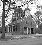
Mooresville Post Office
Built in 1840, this post office is located at the corner of Lauderdale and High streets. It is the oldest post office in Alabama that is still in use! It has special mailboxes that were used even before the American Civil War. Some families have owned the same mailboxes for generations. The mailboxes and some furniture were even used in the nearby Stagecoach Inn before this building was built.
Brick Church
The Brick Church was built in 1839. It is a Greek Revival-style church made of bricks that were handmade. You can find it on Lauderdale Street. It was first a Presbyterian church. Later, it became a Methodist church and a Baptist mission. The church has a special entrance with two columns covered in stucco.
Mooresville Church of Christ
This white church, built in 1854, is on Market Street. It was originally a meeting place for the Disciples of Christ. A back section and an entry area were added to the church in 1937.
Geography of Mooresville
.jpg)
Mooresville is located at 34°37′37″N 86°52′52″W / 34.62694°N 86.88111°W. It is southwest of Huntsville and northeast of Decatur. These cities are all in southern Limestone County. To the south of Mooresville is Wheeler Lake. This lake is an artificial reservoir along the Tennessee River.
The U.S. Census Bureau says that Mooresville covers a total area of about 0.1 square miles (0.26 square kilometers). All of this area is land.
Population Information
| Historical population | |||
|---|---|---|---|
| Census | Pop. | %± | |
| 1870 | 165 | — | |
| 1880 | 183 | 10.9% | |
| 1890 | 143 | −21.9% | |
| 1900 | 150 | 4.9% | |
| 1910 | 137 | −8.7% | |
| 1920 | 144 | 5.1% | |
| 1930 | 114 | −20.8% | |
| 1940 | 129 | 13.2% | |
| 1950 | 101 | −21.7% | |
| 1960 | 93 | −7.9% | |
| 1970 | 72 | −22.6% | |
| 1980 | 58 | −19.4% | |
| 1990 | 54 | −6.9% | |
| 2000 | 59 | 9.3% | |
| 2010 | 53 | −10.2% | |
| 2020 | 47 | −11.3% | |
| U.S. Decennial Census | |||
In the year 2000, there were 59 people living in Mooresville. These people lived in 24 households, with 19 of them being families. The town had about 741 people per square mile.
About 25% of the households had children under 18 living with them. Most households (66.7%) were married couples. About 12.5% of households had a female head with no husband present. The average household had 2.46 people, and the average family had 2.84 people.
The population was spread out by age. About 16.9% were under 18 years old. About 40.7% were between 45 and 64 years old. About 15.3% were 65 years or older. The average age in the town was 50 years.
Education
Students in Mooresville attend schools that are part of the Limestone County School District.
Famous People from Mooresville
- Wade Keyes: He was a lawyer who served as the Confederate States Attorney General during the Civil War.
- James Sloss: He was a planter and businessman. He founded Sloss Furnaces, a famous iron-making company.
Gallery
-
Old Brick Church in Mooresville
-
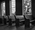
Pews in Old Brick Church


See also
 In Spanish: Mooresville (Alabama) para niños
