Trinity, Alabama facts for kids
Quick facts for kids
Trinity, Alabama
|
|
|---|---|

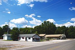
Seneca Drive
|
|

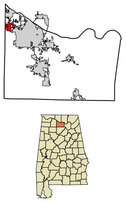
Location in Morgan County, Alabama
|
|
| Country | United States |
| State | Alabama |
| County | Morgan |
| Area | |
| • Total | 4.97 sq mi (12.88 km2) |
| • Land | 4.97 sq mi (12.86 km2) |
| • Water | 0.01 sq mi (0.02 km2) |
| Elevation | 679 ft (207 m) |
| Population
(2020)
|
|
| • Total | 2,526 |
| • Density | 508.66/sq mi (196.40/km2) |
| Time zone | UTC-6 (Central (CST)) |
| • Summer (DST) | UTC-5 (CDT) |
| ZIP code |
35673
|
| Area code(s) | 256 |
| FIPS code | 01-76872 |
| GNIS feature ID | 2406755 |
Trinity is a small town located in Morgan County, Alabama, in the United States. It is part of the larger Decatur Metropolitan Area. In 2020, about 2,526 people lived there, which was more than the 2,095 people counted in 2010. Trinity officially became a town in 1901.
Contents
History of Trinity
Trinity started to grow in the 1810s. Back then, plantation owners built their homes on top of Trinity Mountain. They did this to get away from the lowlands, which had many mosquitoes.
A post office was open in Trinity from 1848 to 1853. It then reopened in 1866 under the name "Trinity Station." The town officially became incorporated in 1901. Two years later, in 1903, its name was shortened to simply "Trinity."
Where is Trinity Located?
Trinity is in the northwestern part of Morgan County. It stretches out between two main roads: U.S. Route 72 to the north and State Route 24 to the south. The town's borders go a little beyond these roads.
The city of Decatur is just to the east of Trinity. To the north, you'll find Wheeler Lake, which is part of the Tennessee River. The southern areas of Trinity are on top of Trinity Mountain. This is a wide hill that rises hundreds of feet above the land around it. To the west, Trinity shares a border with Lawrence County.
The U.S. Census Bureau says that Trinity covers about 5 square miles (12.88 square kilometers). Only a very small part of this area, about 0.16%, is water.
Trinity's Population Over Time
| Historical population | |||
|---|---|---|---|
| Census | Pop. | %± | |
| 1880 | 142 | — | |
| 1900 | 191 | — | |
| 1910 | 198 | 3.7% | |
| 1920 | 243 | 22.7% | |
| 1930 | 208 | −14.4% | |
| 1940 | 249 | 19.7% | |
| 1950 | 342 | 37.3% | |
| 1960 | 454 | 32.7% | |
| 1970 | 881 | 94.1% | |
| 1980 | 1,328 | 50.7% | |
| 1990 | 1,380 | 3.9% | |
| 2000 | 1,841 | 33.4% | |
| 2010 | 2,095 | 13.8% | |
| 2020 | 2,526 | 20.6% | |
| U.S. Decennial Census | |||
The population of Trinity has grown quite a bit over the years. In 1880, only 142 people lived there. By 2020, the population had grown to 2,526 people. This shows how the town has developed and attracted more residents over time.
Population Details from 2010
In 2010, there were 2,095 people living in Trinity. These people lived in 783 households, and 647 of these were families. The town had about 582 people per square mile.
Most of the people in Trinity were White (88.6%). There were also Black or African American people (6.7%), Native American people (1.1%), and Asian people (0.2%). About 1.7% of the population were from other races, and 1.6% were from two or more races. About 3.3% of the people were Hispanic or Latino.
Many households (35.8%) had children under 18 living with them. Most households (71.9%) were married couples. The average household had 2.68 people, and the average family had 2.95 people.
The median age in Trinity was 40.3 years old. This means half the people were younger than 40.3 and half were older.
Population Details from 2020
| Race | Num. | Perc. |
|---|---|---|
| White (non-Hispanic) | 1,873 | 74.15% |
| Black or African American (non-Hispanic) | 223 | 8.83% |
| Native American | 24 | 0.95% |
| Asian | 5 | 0.2% |
| Other/Mixed | 119 | 4.71% |
| Hispanic or Latino | 282 | 11.16% |
As of the 2020 census, Trinity had 2,526 residents. There were 871 households and 637 families living in the town. The table above shows the different racial groups that make up Trinity's population in 2020.
See also
 In Spanish: Trinity (Alabama) para niños
 | Dorothy Vaughan |
 | Charles Henry Turner |
 | Hildrus Poindexter |
 | Henry Cecil McBay |

