Priceville, Alabama facts for kids
Quick facts for kids
Priceville, Alabama
|
|||
|---|---|---|---|

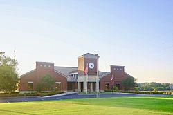
City Hall
|
|||
|
|||

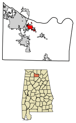
Location in Morgan County, Alabama
|
|||
| Country | United States | ||
| State | Alabama | ||
| County | Morgan | ||
| Area | |||
| • Total | 5.91 sq mi (15.31 km2) | ||
| • Land | 5.88 sq mi (15.22 km2) | ||
| • Water | 0.03 sq mi (0.08 km2) | ||
| Elevation | 600 ft (200 m) | ||
| Population
(2020)
|
|||
| • Total | 3,513 | ||
| • Density | 597.48/sq mi (230.69/km2) | ||
| Time zone | UTC-6 (Central (CST)) | ||
| • Summer (DST) | UTC-5 (CDT) | ||
| FIPS code | 01-62472 | ||
| GNIS feature ID | 2407160 | ||
Priceville is a city in Morgan County, Alabama, in the United States. It is the third largest city in Morgan County. Priceville is part of the larger Decatur Metropolitan Area. In 2020, about 3,513 people lived there. This was more than the 2,658 people counted in 2010. Priceville officially became a city in 1975.
Contents
History of Priceville: How the City Began
Priceville was first settled in the 1820s. The city is named after the Price family, who were important in its early days. For many years, only a few people lived there. But in the 1950s, things changed. When Interstate 65 was built, it brought new businesses and growth to the area.
Geography: Where is Priceville Located?
Priceville is in the northern part of Morgan County. It is located at 34°31′16″N 86°52′47″W / 34.52111°N 86.87972°W. The city of Decatur, which is the county seat, is just to the west.
State Route 67 goes through the center of Priceville. This road leads about 9 miles (14 km) northwest to Decatur. It also goes about 6 miles (10 km) southeast to Somerville. Interstate 65 also runs through the western part of Priceville. This highway connects the city to Cullman, about 26 miles (42 km) south, and Athens, about 19 miles (31 km) north.
The Wheeler National Wildlife Refuge is a natural area between Priceville and Decatur. The Tennessee River (specifically Wheeler Lake) flows just north of Priceville.
The city covers about 5.9 square miles (15.3 square kilometers) of land. A small part, about 0.03 square miles (0.08 square kilometers), is water. Ginhouse Branch is a stream that flows through the middle of Priceville and empties into the Tennessee River.
Population: Who Lives in Priceville?
| Historical population | |||
|---|---|---|---|
| Census | Pop. | %± | |
| 1980 | 966 | — | |
| 1990 | 1,323 | 37.0% | |
| 2000 | 1,631 | 23.3% | |
| 2010 | 2,658 | 63.0% | |
| 2020 | 3,513 | 32.2% | |
| U.S. Decennial Census 2013 Estimate |
|||
2020 Census: A Look at the Population
In 2020, the 2020 United States census counted 3,512 people living in Priceville. There were 1,204 households and 945 families. Most people in Priceville are White (86.99%). Other groups include Black or African American (3.5%), Asian (1.48%), Native American (0.48%), and Pacific Islander (0.05%). About 4.33% of people were of mixed races. Also, 3.19% of the population was Hispanic or Latino.
2010 Census: How Priceville Grew
The census in 2010 showed that 2,658 people lived in Priceville. There were 620 households and 518 families. The city had about 316 people per square mile (122 people per square kilometer).
Most people in Priceville were White (95.89%). Other groups included Black or African American (2.27%), Native American (0.67%), and Asian (0.18%). About 1.23% of the population was Hispanic or Latino.
In 2010, about 23.9% of the people were under 18 years old. About 11.2% were 65 years or older. The average age in Priceville was 38 years.
See also
 In Spanish: Priceville para niños
 | Jackie Robinson |
 | Jack Johnson |
 | Althea Gibson |
 | Arthur Ashe |
 | Muhammad Ali |


