
Cullman, Alabama facts for kids
Quick facts for kids
Cullman, Alabama
|
|||
|---|---|---|---|
.1.jpg)
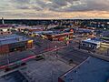
Hwy 278 & Hwy 31
|
|||
|
|||
| Motto(s):
"A City of Character"
|
|||

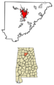
Location of Cullman in Cullman County, Alabama
|
|||
| Country | United States | ||
| State | Alabama | ||
| County | Cullman | ||
| Founded | 1873 | ||
| Incorporated | March 6, 1875 | ||
| Named for | Colonel Johann Gottfried Cullmann | ||
| Government | |||
| • Type | Mayor-Council | ||
| Area | |||
| • City | 24.046 sq mi (62.279 km2) | ||
| • Land | 22.704 sq mi (58.802 km2) | ||
| • Water | 1.342 sq mi (3.477 km2) | ||
| Elevation | 814 ft (248 m) | ||
| Population
(2020)
|
|||
| • City | 18,213 | ||
| • Estimate
(2022)
|
19,251 | ||
| • Density | 851/sq mi (328.6/km2) | ||
| • Urban | 21,165 | ||
| • Urban density | 985/sq mi (380.2/km2) | ||
| • Metro | 90,665 | ||
| • Metro density | 123.4/sq mi (47.64/km2) | ||
| Time zone | UTC−6 (Central (CST)) | ||
| • Summer (DST) | UTC−5 (CDT) | ||
| ZIP Code |
35055, 35056, 35057, 35058
|
||
| Area code(s) | 256 and 938 | ||
| FIPS code | 01-18976 | ||
| GNIS feature ID | 2404166 | ||


Cullman is the biggest city and the county seat of Cullman County, Alabama, in the United States. It's located right along Interstate 65. You can find it about 50 miles (80 km) north of Birmingham and about 55 miles (89 km) south of Huntsville. In 2020, about 18,213 people lived there. By 2022, the population was estimated to be around 19,251.
Contents
Discovering Cullman's Past
Before Europeans arrived, the land where Cullman now stands belonged to the Cherokee Nation. An important path, called the Black Warrior's Path, crossed this area. It connected the Tennessee River to the Black Warrior River. This trail was very important in Cherokee history. It was also used during the American Indian Wars before Alabama became a state. Many Native American tribes, like the Creek people, were forced to leave their homes along the Trail of Tears. In 1813, during the Creek War, General Andrew Jackson sent troops down this path. The famous frontiersman Davy Crockett was one of them.
Early Roads and Trails
In the 1820s and 1830s, two toll roads were built. These roads connected the Tennessee Valley to what is now Birmingham. One road, called Stout's Road, was built in 1822. It passed through the Cullman area. Later, another road, the Brindley Turnpike, was built. It joined Stout's Road north of the city. Cullman eventually grew up where these two important roads met. These old roads were even around before U.S. Route 31.
Cullman During the Civil War
During the Civil War, a small battle happened near where Cullman is today. It was called the Battle of Day's Gap. On April 30, 1863, Union soldiers led by Colonel Abel Streight won against Confederate soldiers led by General Nathan Bedford Forrest. This battle was part of a bigger event called Streight's Raid. Even though Streight won this battle, Forrest later tricked him. Forrest made his soldiers march in circles so Streight would think he was outnumbered. Streight then surrendered, even though his force was actually larger!

Founding of Cullman by German Immigrants
Cullman was founded in 1873 by Colonel John G. Cullmann. He was a German immigrant. Cullmann had fought for democratic changes in his home country of Bavaria during the Revolutions of 1848–49. After the revolution failed, he faced financial problems. He also felt his political ideas didn't fit with the German government at the time. So, he decided to move to America in 1865.
In 1871, Cullmann moved to Alabama. In 1873, he made a deal to buy a huge piece of land, about 349,000 acres (1,412 km2). He wanted to create a new home for German immigrants. Five German families moved there in March 1873. In 1874, the town was officially named Cullman, after him. Over the next 20 years, Cullmann encouraged about 100,000 Germans to come to the United States. Many of them settled in the Cullman area. Cullmann used his military engineering skills to plan the town's layout. Cullman grew a lot during this time. The German language was commonly spoken, and Cullmann even published a German newspaper. He passed away in 1895 at age 72. His funeral was attended by the Governor of Alabama. Today, his grave is located where his original headquarters once stood.
German immigrants also built St. Bernard's Monastery. On its grounds, you can find the Ave Maria Grotto. This grotto has 125 small models of famous religious buildings from around the world. It's a major tourist spot in Cullman.
For many years, Cullman had a rule that African Americans were not allowed to live there. This led to the growth of a nearby town called Colony, Alabama, which became a safe place for them.
Education and Economy Changes
For a long time, Cullman was known as a college town because of Saint Bernard College. This college had hundreds of students. In the 1970s, it briefly merged with another college. It closed in 1979, but the site is now St. Bernard Preparatory School, which teaches grades 9-12. The former site of Sacred Heart College is now a retreat center run by Benedictine Sisters.
In the 20th century, Cullman's economy grew to include many different types of businesses, like factories and distribution centers. Cullman is often recognized as one of the best "micropolitan" cities in the country. A micropolitan area is a city with a population between 10,000 and 50,000 that influences the surrounding area.
Cullman also made national news in 2008. A special election was held, and James C. Fields, an African American, was elected to the Alabama House of Representatives from the district that includes Cullman.
During World War I and World War II, when the United States was fighting Germany, Cullman's German heritage was not celebrated as much. But in the 1970s, people became interested in the city's history again. Today, Cullman holds an annual Oktoberfest, a German festival. They even elect an honorary "Bürgermeister" (mayor) for each Oktoberfest!
Exploring Cullman's Geography
Cullman is located on top of the Brindley Mountain plateau. This area is part of Sand Mountain, which is the southernmost part of the Appalachian Mountains. The city is about 814 feet (248 meters) above sea level. This spot is close to where the water flows either towards the Tennessee River or the Black Warrior River. Cullman gets its drinking water from Lake Catoma, a city-owned lake within its boundaries.
The city covers a total area of about 24.046 square miles (62.279 km2). Most of this, about 22.704 square miles (58.802 km2), is land. The rest, about 1.342 square miles (3.477 km2), is water. New rules for building have helped the downtown Cullman area grow and expand.
Cullman's Climate
The weather in Cullman features hot, humid summers. Winters are generally mild to cool. Cullman has what is called a humid subtropical climate. This means it gets plenty of rain throughout the year, and the temperatures are usually warm.
| Climate data for Cullman, Alabama (Saint Bernard) (1991–2020 normals, extremes 1907–present) | |||||||||||||
|---|---|---|---|---|---|---|---|---|---|---|---|---|---|
| Month | Jan | Feb | Mar | Apr | May | Jun | Jul | Aug | Sep | Oct | Nov | Dec | Year |
| Record high °F (°C) | 80 (27) |
85 (29) |
89 (32) |
92 (33) |
96 (36) |
104 (40) |
110 (43) |
108 (42) |
107 (42) |
98 (37) |
89 (32) |
80 (27) |
110 (43) |
| Mean maximum °F (°C) | 70.4 (21.3) |
75.4 (24.1) |
81.2 (27.3) |
86.0 (30.0) |
90.1 (32.3) |
94.8 (34.9) |
97.1 (36.2) |
96.9 (36.1) |
94.4 (34.7) |
87.1 (30.6) |
79.4 (26.3) |
71.8 (22.1) |
98.9 (37.2) |
| Mean daily maximum °F (°C) | 52.3 (11.3) |
57.2 (14.0) |
65.2 (18.4) |
73.7 (23.2) |
80.5 (26.9) |
86.7 (30.4) |
89.7 (32.1) |
89.6 (32.0) |
84.7 (29.3) |
74.6 (23.7) |
63.3 (17.4) |
55.1 (12.8) |
72.7 (22.6) |
| Daily mean °F (°C) | 41.9 (5.5) |
46.1 (7.8) |
53.4 (11.9) |
61.5 (16.4) |
69.1 (20.6) |
76.0 (24.4) |
79.4 (26.3) |
79.4 (26.3) |
73.4 (23.0) |
62.1 (16.7) |
51.1 (10.6) |
44.4 (6.9) |
61.5 (16.4) |
| Mean daily minimum °F (°C) | 31.5 (−0.3) |
34.9 (1.6) |
41.6 (5.3) |
49.4 (9.7) |
57.8 (14.3) |
65.3 (18.5) |
69.2 (20.7) |
69.2 (20.7) |
62.1 (16.7) |
49.7 (9.8) |
38.9 (3.8) |
33.7 (0.9) |
50.3 (10.1) |
| Mean minimum °F (°C) | 11.1 (−11.6) |
15.6 (−9.1) |
21.2 (−6.0) |
30.2 (−1.0) |
40.4 (4.7) |
52.3 (11.3) |
59.0 (15.0) |
57.7 (14.3) |
46.0 (7.8) |
31.2 (−0.4) |
20.9 (−6.2) |
16.7 (−8.5) |
8.9 (−12.8) |
| Record low °F (°C) | −17 (−27) |
−7 (−22) |
5 (−15) |
21 (−6) |
30 (−1) |
40 (4) |
48 (9) |
48 (9) |
34 (1) |
19 (−7) |
2 (−17) |
−5 (−21) |
−17 (−27) |
| Average precipitation inches (mm) | 5.72 (145) |
5.86 (149) |
5.68 (144) |
5.43 (138) |
4.93 (125) |
4.86 (123) |
4.58 (116) |
3.93 (100) |
4.61 (117) |
3.91 (99) |
4.94 (125) |
5.87 (149) |
60.32 (1,530) |
| Average snowfall inches (cm) | 0.3 (0.76) |
0.3 (0.76) |
0.3 (0.76) |
0.0 (0.0) |
0.0 (0.0) |
0.0 (0.0) |
0.0 (0.0) |
0.0 (0.0) |
0.0 (0.0) |
0.0 (0.0) |
0.0 (0.0) |
0.1 (0.25) |
1.1 (2.8) |
| Average precipitation days (≥ 0.01 in) | 9.4 | 9.7 | 10.4 | 8.2 | 9.2 | 9.7 | 9.8 | 8.4 | 6.4 | 6.6 | 7.5 | 9.8 | 105.1 |
| Average snowy days (≥ 0.1 in) | 0.2 | 0.2 | 0.1 | 0.0 | 0.0 | 0.0 | 0.0 | 0.0 | 0.0 | 0.0 | 0.0 | 0.0 | 0.6 |
| Source: NOAA | |||||||||||||
Severe Weather Events

Downtown Cullman was badly damaged by a very strong tornado in 2011. This tornado, called an EF4 tornado, hit on April 27 during the 2011 Super Outbreak. It destroyed many buildings in the downtown area and a neighborhood on the east side. Luckily, no one died in Cullman itself. The tornado then moved northeast, causing deaths in other parts of Cullman County and nearby towns. Since then, Cullman has worked hard to rebuild and improve its downtown area.
Learning in Cullman: Schools and Colleges
The Cullman City School System runs most of the schools in the city. Here are the schools they operate:
- Cullman Primary School (Pre-Kindergarten to 2nd grade)
- East Elementary (3rd to 5th grade)
- West Elementary (3rd to 6th grade)
- John G. Cullman Middle School (6th and 8th grades)
- Cullman High School (9th to 12th grade)
Some small parts of Cullman City are in the Cullman County School District.
Other schools in Cullman include:
- Saint Bernard Preparatory School, a Benedictine boarding and day school (9th to 12th grade)
- Saint Bernard Middle School (7th and 8th grade)
- Sacred Heart Elementary School (Pre-Kindergarten to 6th grade)
- Saint Paul's Lutheran School (Pre-Kindergarten to 6th grade)
- Cullman Christian School (Pre-Kindergarten to 12th grade)
Cullman is also home to Wallace State Community College in Hanceville.
Cullman's Population and People
| Historical population | |||
|---|---|---|---|
| Census | Pop. | %± | |
| 1880 | 426 | — | |
| 1890 | 1,017 | 138.7% | |
| 1900 | 1,255 | 23.4% | |
| 1910 | 2,130 | 69.7% | |
| 1920 | 2,467 | 15.8% | |
| 1930 | 2,786 | 12.9% | |
| 1940 | 5,074 | 82.1% | |
| 1950 | 7,523 | 48.3% | |
| 1960 | 10,883 | 44.7% | |
| 1970 | 12,601 | 15.8% | |
| 1980 | 13,084 | 3.8% | |
| 1990 | 13,367 | 2.2% | |
| 2000 | 13,995 | 4.7% | |
| 2010 | 14,775 | 5.6% | |
| 2020 | 18,213 | 23.3% | |
| 2022 (est.) | 19,251 | 30.3% | |
| U.S. Decennial Census 2020 Census |
|||
Population in 2020
| Race | Number | Percent |
|---|---|---|
| White (non-Hispanic) | 15,883 | 87.21% |
| Black or African American (non-Hispanic) | 236 | 1.3% |
| Native American | 29 | 0.16% |
| Asian | 291 | 1.6% |
| Pacific Islander | 4 | 0.02% |
| Other/Mixed | 731 | 4.01% |
| Hispanic or Latino | 1,039 | 5.7% |
In 2020, the city of Cullman had 18,213 people living there. There were 7,445 households and 4,614 families.
Population in 2010
In 2010, Cullman had 14,775 people. About 95% of the people were White. Around 6.8% of the population was Hispanic or Latino.
The average household had about 2.22 people. The average family had about 2.85 people. About 21.8% of the population was under 18 years old. Around 22.1% of the population was 65 years or older. The average age in the city was 41 years.
Cullman in the Media
Radio Stations
- WFMH 1340 AM (Sports/Talk)
- WKUL 92.1 FM (Country/Talk)
- WRJM-LP 95.5 FM (CHR/AAA/Variety)
- WMCJ 1460 AM (Southern Gospel)
- WXJC-FM 101.1 FM (Gospel/Talk)
Newspapers
- The Cullman Times (daily)
- The Cullman Tribune (daily)
Television
Cullman is in the TV broadcasting areas of Birmingham and Huntsville, Alabama.
There are two local low-power TV stations in Cullman: WCQT-LD TV-27 and CATV-2. Cullman also has a public access TV station, CCTV55. This station is run by students at Cullman High School.
Getting Around Cullman
Here are the main ways to travel in and around Cullman:
 Interstate 65
 U.S. Highway 31
 U.S. Highway 278
 State Route 69
 State Route 157
- CSX Transportation (railroad)
- Folsom Field municipal airport
Famous People from Cullman
Many interesting people have come from Cullman, including:
- JoJo Billingsley, a singer and songwriter
- Wesley Britt, a former NFL football player
- Paul Burnum, a former basketball and baseball coach
- Paul Bussman, a member of the Alabama Senate
- Caleb Clay, a former MLB baseball pitcher
- Melinda Dillon, an actress
- Jamelle Folsom, First Lady of Alabama (1948–1951 and 1955–1959)
- James E. "Big Jim" Folsom, Governor of Alabama (1947–1951 and 1955–1959)
- James E. "Little Jim" Folsom Jr., Governor of Alabama (1993–1995) and Lieutenant Governor (1987–1993 and 2007–2011)
- Morgan Smith Goodwin, an actress
- Roger Hallmark, a country musician
- Kurt Heinecke, a composer and voice actor
- Brett Hestla, a former touring bass player for the band Creed
- Charles Kleibacker, a fashion designer
- Jordan Lee, a bass fisherman
- Harold E. Martin, a journalist and Pulitzer Prize winner
- William C. Martin, a physicist
- Julian L. McPhillips, a political candidate
- David Miller, an NFL football player
- Kassie Miller, a singer and songwriter
- Talmadge Prince, a stock car racing driver
- Josh Rutledge, a former MLB baseball player
- Shallow Side, a rock music band formed in 2011
- Grant Sikes, an internet personality
- Frank Stitt, a chef
- Channing Tatum, an actor and model
- Keegan Thompson, an MLB baseball pitcher
- Wayne Trimble, an American football player
- Zac Tubbs, an American football player
- Holly Williams, a country music singer
- Larry Willingham, an NFL football player
Images for kids
-
Hwy 278 & Hwy 31
-

Flag of Cullman, Alabama
-

Logo of Cullman, Alabama
-
Location of Cullman in Cullman County, Alabama
-

Colonel John G. Cullmann, founder of Cullman (1823–1895)
-
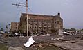
Damage from the 2011 tornado in Cullman
See also
 In Spanish: Cullman (Alabama) para niños
