Blount County, Alabama facts for kids
Quick facts for kids
Blount County
|
|||
|---|---|---|---|

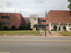
Blount County Courthouse in Oneonta
|
|||
|
|||

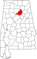
Location within the U.S. state of Alabama
|
|||
 Alabama's location within the U.S. |
|||
| Country | |||
| State | |||
| Founded | February 6, 1818 | ||
| Named for | Willie Blount | ||
| Seat | Oneonta | ||
| Largest city | Oneonta | ||
| Area | |||
| • Total | 651 sq mi (1,690 km2) | ||
| • Land | 645 sq mi (1,670 km2) | ||
| • Water | 5.9 sq mi (15 km2) 0.9% | ||
| Population
(2020)
|
|||
| • Total | 59,134 | ||
| • Estimate
(2023)
|
59,816 |
||
| • Density | 90.84/sq mi (35.072/km2) | ||
| Time zone | UTC−6 (Central) | ||
| • Summer (DST) | UTC−5 (CDT) | ||
| Congressional district | 6th | ||
|
|||
Blount County is a county in the state of Alabama, USA. As of the 2020 census, about 59,134 people lived here. The main town and county seat is Oneonta.
Blount County is often called the "Covered Bridge Capital of Alabama." This is because it has more historic covered bridges than any other county in the state. Every autumn, Oneonta celebrates these bridges with a special festival.
Contents
History of Blount County
Blount County was created on February 6, 1818. The Alabama Territorial Legislature formed it from land. This land was given to the U.S. government by the Creek Nation in 1814.
The county got its name from Governor Willie Blount of Tennessee. He helped settlers in Alabama during the Creek War. Blount County is in the northeastern part of Alabama. This area is sometimes known for its minerals.
Blount County shares borders with several other counties. These include Cullman, Marshall, Etowah, Jefferson, Walker, and St. Clair Counties. The Black Warrior River's Locust and Mulberry Forks flow through the county. Blount County covers about 650 square miles (1,683 square kilometers). It is also home to part of the Warrior coal field.
In 1816, Caleb Fryley and John Jones started a settlement called Bear Meat Cabin. This was an English name for a Native American village called Wassausey. A post office opened there in 1821. The settlement became a town called Blountsville in 1827. Later, in 1889, the county seat moved to Oneonta, Alabama.
Geography and Location
Blount County has a total area of about 651 square miles (1,686 square kilometers). Most of this area, 645 square miles (1,671 square kilometers), is land. Only about 5.9 square miles (15 square kilometers) is water.
Neighboring Counties
Blount County is surrounded by these counties:
- Marshall County – to the northeast
- Etowah County – to the east
- St. Clair County – to the southeast
- Walker County – to the southwest
- Jefferson County – to the south
- Cullman County – to the northwest
Transportation in Blount County
Getting around Blount County is easy with several major roads.
Major Highways
 Interstate 65
 U.S. Highway 31
 U.S. Highway 231
 U.S. Highway 278
 State Route 67
 State Route 75
 State Route 79
 State Route 132
 State Route 160
Railways
- CSX Transportation (This used to be the Louisville and Nashville Railroad)
Population and People
| Historical population | |||
|---|---|---|---|
| Census | Pop. | %± | |
| 1820 | 2,415 | — | |
| 1830 | 4,233 | 75.3% | |
| 1840 | 5,570 | 31.6% | |
| 1850 | 7,367 | 32.3% | |
| 1860 | 10,865 | 47.5% | |
| 1870 | 9,945 | −8.5% | |
| 1880 | 15,369 | 54.5% | |
| 1890 | 21,927 | 42.7% | |
| 1900 | 23,119 | 5.4% | |
| 1910 | 21,456 | −7.2% | |
| 1920 | 25,538 | 19.0% | |
| 1930 | 28,020 | 9.7% | |
| 1940 | 29,490 | 5.2% | |
| 1950 | 28,975 | −1.7% | |
| 1960 | 25,449 | −12.2% | |
| 1970 | 26,853 | 5.5% | |
| 1980 | 36,459 | 35.8% | |
| 1990 | 39,248 | 7.6% | |
| 2000 | 51,024 | 30.0% | |
| 2010 | 57,322 | 12.3% | |
| 2020 | 59,134 | 3.2% | |
| 2023 (est.) | 59,816 | 4.4% | |
| U.S. Decennial Census 1790–1960 1900–1990 1990–2000 2010–2020 |
|||
How Many People Live Here?
In 2020, the U.S. census counted 59,134 people living in Blount County. There were 20,847 households and 14,874 families.
In 2010, there were 57,322 people. The county had about 88.79 people per square mile. Most people (92.6%) were White. About 8.1% of the population was Hispanic or Latino.
The average household had 2.63 people. The average family had 3.72 people. About 25.40% of the population was under 18 years old. About 12.90% were 65 years or older. The median age was 36 years.
Education in Blount County
Blount County has two public school districts. Around 9,200 students attend public schools from pre-kindergarten to 12th grade.
School Districts
The school districts in Blount County are:
- Blount County School District
- Oneonta City School District
Communities in Blount County
Blount County has several towns and cities where people live.
Cities
- Oneonta (This is the county seat)
- Warrior (Partly in Jefferson County)
Towns
- Allgood
- Altoona (partly in Etowah County)
- Blountsville
- Cleveland
- County Line (partly in Jefferson County)
- Garden City (partly in Cullman County)
- Hayden
- Highland Lake
- Locust Fork
- Nectar
- Rosa
- Snead
- Susan Moore
- Trafford (partly in Jefferson County)
Census-Designated Places
These are areas that are like towns but are not officially incorporated.
Unincorporated Communities
These are smaller communities that are not part of any city or town.
Fun Places to Visit
Blount County offers many outdoor activities for visitors. You can explore Rickwood Caverns State Park. The Locust Fork of the Black Warrior River is great for canoeing and kayaking.
The county is also famous for its beautiful covered bridges. These include the Swann Covered Bridge, the Horton Mill Covered Bridge, and the Easley Covered Bridge. These bridges were closed for safety reasons for a while. But they were repaired between 2011 and 2013 and are now open again for everyone to enjoy!
See also
 In Spanish: Condado de Blount (Alabama) para niños
 | John T. Biggers |
 | Thomas Blackshear |
 | Mark Bradford |
 | Beverly Buchanan |


