Cleveland, Alabama facts for kids
Quick facts for kids
Cleveland, Alabama
|
||
|---|---|---|

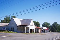
View along U.S. Route 231 in Cleveland
|
||
|
||

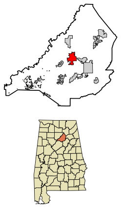
Location of Cleveland in Blount County, Alabama.
|
||
| Country | United States | |
| State | Alabama | |
| County | Blount | |
| Government | ||
| • Type | Town Hall | |
| Area | ||
| • Total | 7.88 sq mi (20.42 km2) | |
| • Land | 7.85 sq mi (20.33 km2) | |
| • Water | 0.03 sq mi (0.09 km2) | |
| Elevation | 525 ft (160 m) | |
| Population
(2020)
|
||
| • Total | 1,245 | |
| • Density | 158.60/sq mi (61.23/km2) | |
| Time zone | UTC-6 (Central (CST)) | |
| • Summer (DST) | UTC-5 (CDT) | |
| ZIP code |
35049
|
|
| Area code(s) | 205, 659 | |
| FIPS code | 01-15472 | |
| GNIS feature ID | 0157920 | |
| Website | Town of Cleveland | |
Cleveland is a small town located in Blount County, Alabama, in the United States. It's a friendly community where about 1,245 people lived according to the 2020 census.
Contents
A Look Back in Time: Cleveland's History
Cleveland was first settled way back in the 1820s. It started as a small community.
How Cleveland Got Its Name
At first, the area was known as Dry Creek Crossroads. Later, it was called Blackwood's Crossroads. This name came from a local business owner named John Blackwood.
When a post office was set up, the community was named Cleveland. This was done to honor President Grover Cleveland. The town officially became a town in 1964.
Where is Cleveland?
Cleveland is located in the middle part of Blount County. You can find it at about 33.99 degrees North and 86.57 degrees West.
Natural Features and Roads
The Locust Fork of the Black Warrior River flows along the northwest side of the town. Just west of Cleveland, you can find the famous Swann Covered Bridge. This historic bridge crosses the river.
Major roads also pass through Cleveland. U.S. Route 231 meets Alabama State Route 79 north of the town center. Route 231 goes southeast about 7 miles (11 km) to Oneonta. Oneonta is the county seat, which means it's where the county government is located. Route 231 also goes north about 56 miles (90 km) to Huntsville.
Route 79 heads northeast about 31 miles (50 km) to Guntersville. It also goes southwest about 37 miles (60 km) to Birmingham.
Size of the Town
The town of Cleveland covers a total area of about 7.88 square miles (20.4 square kilometers). Most of this area is land, with only a small part being water.
Who Lives in Cleveland?
| Historical population | |||
|---|---|---|---|
| Census | Pop. | %± | |
| 1970 | 413 | — | |
| 1980 | 487 | 17.9% | |
| 1990 | 739 | 51.7% | |
| 2000 | 1,241 | 67.9% | |
| 2010 | 1,303 | 5.0% | |
| 2020 | 1,245 | −4.5% | |
| U.S. Decennial Census 2013 Estimate |
|||
According to the 2020 United States census, there were 1,245 people living in Cleveland. These people lived in 522 households, with 360 of them being families.
The town's population has changed over the years. In 1970, there were 413 people. The population grew to 1,303 in 2010 before slightly decreasing to 1,245 in 2020.
Notable People from Cleveland
- Kevin Sherrer is a well-known person from Cleveland. He played college football at Alabama. Later, he became a successful football coach for high school, college, and even NFL teams.
See also
 In Spanish: Cleveland (Alabama) para niños
 | Stephanie Wilson |
 | Charles Bolden |
 | Ronald McNair |
 | Frederick D. Gregory |


