Smoke Rise, Alabama facts for kids
Quick facts for kids
Smoke Rise, Alabama
|
|
|---|---|

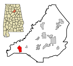
Location in Blount County and the state of Alabama
|
|
| Country | United States |
| State | Alabama |
| County | Blount |
| Area | |
| • Total | 5.82 sq mi (15.06 km2) |
| • Land | 5.80 sq mi (15.03 km2) |
| • Water | 0.01 sq mi (0.03 km2) |
| Elevation | 1,030 ft (314 m) |
| Population
(2020)
|
|
| • Total | 1,661 |
| • Density | 286.18/sq mi (110.50/km2) |
| Time zone | UTC-6 (Central (CST)) |
| • Summer (DST) | UTC-5 (CDT) |
| FIPS code | 01-71201 |
| GNIS feature ID | 0135171 |
Smoke Rise is a community in Blount County, Alabama, United States. It's known as a census-designated place (CDP). This means it's an area identified by the government for counting people, but it's not an official city or town. In 2020, about 1,661 people lived there.
Contents
Discovering Smoke Rise History
Smoke Rise is located in western Blount County, east of Interstate 65. Many homes in the community are built on top of Bryant Mountain or in the valley below.
How Smoke Rise Began
This community started in the late 1960s. It was planned as a large neighborhood with many homes. The original idea was to have its own school right in Smoke Rise. However, those plans didn't happen. Today, children living in Smoke Rise go to public schools in nearby Hayden.
Community Life and Growth
In the mid-1990s, residents created the Smoke Rise Homeowners Association. This group helps manage things for the people living there. Even with this association, Smoke Rise is not an official town. People sometimes talk about making it an official town, but it hasn't happened yet.
There aren't many businesses right in Smoke Rise. However, a new sewer system is being built in western Blount County. Many people think this will help more businesses come to the area.
Exploring Smoke Rise Geography
Smoke Rise is located at coordinates 33°52'26.666" North and 86°49'33.643" West.
The U.S. Census Bureau says that the total area of Smoke Rise is about 6.4 square miles (16.6 square kilometers). Almost all of this area is land. Only a very small part, about 0.16%, is water.
Understanding Smoke Rise Population
| Historical population | |||
|---|---|---|---|
| Census | Pop. | %± | |
| 2020 | 1,661 | — | |
| U.S. Decennial Census | |||
People in Smoke Rise: 2020 Census
The 2020 United States census counted 1,661 people living in Smoke Rise. There were 662 households and 575 families.
| Group | Number of People | Percentage |
|---|---|---|
| White (not Hispanic) | 1,572 | 94.64% |
| Black or African American (not Hispanic) | 4 | 0.24% |
| Native American | 3 | 0.18% |
| Asian | 2 | 0.12% |
| Other/Mixed | 56 | 3.37% |
| Hispanic or Latino | 24 | 1.44% |
People in Smoke Rise: 2010 Census
In 2010, the census showed that 1,825 people lived in Smoke Rise. There were 692 households and 566 families. The population density was about 290 people per square mile (111.9 people per square kilometer).
Most of the people in Smoke Rise were White (98.0%). A small number were Native American (0.5%), Asian (0.1%), or from two or more races (0.8%). About 0.7% of the population was Hispanic or Latino.
Households and Families
Out of the 692 households in 2010:
- 27.7% had children under 18 living with them.
- 69.8% were married couples living together.
- 9.0% had a female head of household with no husband present.
- 18.2% were not families (individuals living alone or with non-relatives).
The average household had 2.64 people, and the average family had 2.91 people.
Age and Income
In 2010, the age breakdown of the population was:
- 21.1% were under 18 years old.
- 6.8% were from 18 to 24 years old.
- 23.0% were from 25 to 44 years old.
- 32.6% were from 45 to 64 years old.
- 16.5% were 65 years or older.
The average age in Smoke Rise was 44.4 years.
The median income for a household was $71,446. For a family, the median income was $80,333. The average income per person was $27,909. Very few families or individuals were living below the poverty line.
See also
 In Spanish: Smoke Rise (Alabama) para niños
 | Dorothy Vaughan |
 | Charles Henry Turner |
 | Hildrus Poindexter |
 | Henry Cecil McBay |

