Hodges, Alabama facts for kids
Quick facts for kids
Hodges, Alabama
|
|
|---|---|

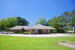
Town Hall
|
|

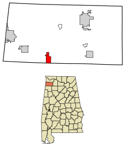
Location of Hodges in Franklin County, Alabama.
|
|
| Country | United States |
| State | Alabama |
| County | Franklin |
| Area | |
| • Total | 4.13 sq mi (10.71 km2) |
| • Land | 4.13 sq mi (10.69 km2) |
| • Water | 0.01 sq mi (0.02 km2) |
| Elevation | 863 ft (263 m) |
| Population
(2020)
|
|
| • Total | 265 |
| • Density | 64.21/sq mi (24.79/km2) |
| Time zone | UTC-6 (Central (CST)) |
| • Summer (DST) | UTC-5 (CDT) |
| ZIP code |
35571
|
| Area code(s) | 205,256 |
| FIPS code | 01-35200 |
| GNIS feature ID | 0120172 |
Hodges is a small town located in Franklin County, Alabama, in the United States. In 2020, about 265 people lived there. The town was first planned in 1902 and officially became a town (incorporated) in 1913.
A Look Back at Hodges' History
Before Hodges became a town, there was a community called "Reid Brake" in the 1880s. The town we know today was started in 1907. It was created as a stop along the Illinois Central Railroad and was named after an important local family. Hodges officially became a town in 1913, and then again in 1919.
Where is Hodges Located?
Hodges is found in the southern part of Franklin County. Its southern edge is right on the border with Marion County.
You can get to Hodges using Alabama State Route 172, which goes northwest to Vina (about 9 miles away) and southeast to Hackleburg (about 7 miles away). Alabama State Route 187 also leads northeast from Hodges to Belgreen, which is about 13 miles away.
The town covers about 4.13 square miles (10.7 square kilometers) of land. Only a very small part of it is water. Hodges sits on something called the Tennessee Valley Divide. This means that water on the east side of town flows into Bear Creek, which eventually goes into the Tennessee River. Water on the west side flows into Skirum Branch, which then goes into Bull Mountain Creek and finally into the Tombigbee River.
Just 2 miles north of Hodges, you can find Rock Bridge Canyon Park. It has cool bluffs that look over Bear Creek.
Who Lives in Hodges?
| Historical population | |||
|---|---|---|---|
| Census | Pop. | %± | |
| 1920 | 279 | — | |
| 1930 | 247 | −11.5% | |
| 1940 | 260 | 5.3% | |
| 1950 | 220 | −15.4% | |
| 1960 | 194 | −11.8% | |
| 1970 | 207 | 6.7% | |
| 1980 | 250 | 20.8% | |
| 1990 | 272 | 8.8% | |
| 2000 | 261 | −4.0% | |
| 2010 | 288 | 10.3% | |
| 2020 | 265 | −8.0% | |
| U.S. Decennial Census 2013 Estimate |
|||
According to the census from 2000, there were 261 people living in Hodges. These people made up 98 households, and 78 of those were families. The town had about 84 people per square mile.
- About 32.7% of households had kids under 18 living with them.
- Most households (62.2%) were married couples living together.
- About 19.4% of households were single people living alone.
The average household had about 2.66 people, and the average family had about 3.05 people.
The people in Hodges were spread out by age:
- 23.0% were under 18 years old.
- 10.0% were between 18 and 24.
- 26.1% were between 25 and 44.
- 23.8% were between 45 and 64.
- 17.2% were 65 years or older.
The average age in town was 39 years. For every 100 females, there were about 97.7 males.
The average income for a household in Hodges was $33,750. For families, the average income was $38,333. About 13.4% of the town's population lived below the poverty line. This included 12.3% of those under 18 and 18.2% of those 65 or older.
See also
 In Spanish: Hodges (Alabama) para niños
 | Aurelia Browder |
 | Nannie Helen Burroughs |
 | Michelle Alexander |

