Gattman, Mississippi facts for kids
Quick facts for kids
Gattman, Mississippi
|
|
|---|---|
|
Village
|
|
 |
|

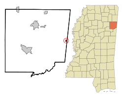
Location in Monroe County and the state of Mississippi
|
|
| Country | United States |
| State | Mississippi |
| County | Monroe |
| Area | |
| • Total | 0.56 sq mi (1.46 km2) |
| • Land | 0.56 sq mi (1.46 km2) |
| • Water | 0.00 sq mi (0.00 km2) |
| Elevation | 295 ft (90 m) |
| Population
(2020)
|
|
| • Total | 77 |
| • Density | 137.01/sq mi (52.87/km2) |
| Time zone | UTC-6 (Central (CST)) |
| • Summer (DST) | UTC-5 (CDT) |
| ZIP codes |
38844 (Gattman)
39740 (Caledonia) |
| Area code(s) | 662 |
| FIPS code | 28-26780 |
| GNIS feature ID | 670338 |
Gattman is a small village located in Monroe County, Mississippi, in the United States. It's a quiet place with a friendly community. In 2020, about 77 people lived there. This was a slight decrease from 90 people in 2010.
Contents
Geography of Gattman
Gattman is located in the eastern part of Monroe County. It sits right next to the state of Alabama on its eastern side.
Roads and Nearby Towns
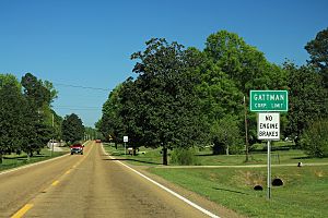
U.S. Route 278 is a main road that goes through the village. If you travel northwest on this road for about 17 miles, you'll reach Amory. Going east for about 6 miles will take you to Sulligent. The county seat of Monroe, Aberdeen, is about 20 miles southwest of Gattman. You can get there using US 278 and Mississippi Highway 8.
Land and Water
The village of Gattman covers an area of about 0.56 square miles (1.46 square kilometers), and all of it is land. There are no large bodies of water within the village limits. The Buttahatchee River flows just north of Gattman. This river eventually joins the Tombigbee River near Columbus Air Force Base.
Population Changes in Gattman
| Historical population | |||
|---|---|---|---|
| Census | Pop. | %± | |
| 1900 | 111 | — | |
| 1910 | 155 | 39.6% | |
| 1920 | 151 | −2.6% | |
| 1930 | 158 | 4.6% | |
| 1940 | 186 | 17.7% | |
| 1950 | 150 | −19.4% | |
| 1960 | 145 | −3.3% | |
| 1970 | 175 | 20.7% | |
| 1980 | 151 | −13.7% | |
| 1990 | 120 | −20.5% | |
| 2000 | 114 | −5.0% | |
| 2010 | 90 | −21.1% | |
| 2020 | 77 | −14.4% | |
| U.S. Decennial Census | |||
The population of Gattman has changed over the years. In 1900, there were 111 people living there. The population grew to its highest point in 1940 with 186 residents. Since then, the number of people living in Gattman has generally decreased. In 2020, the population was 77.
Who Lives in Gattman?
Based on information from the year 2000, there were 114 people living in Gattman. Most of the residents (about 95.61%) were White, and about 4.39% were African American.
There were 50 households in the village. A household means all the people living in one home.
- About 22% of these households had children under 18 living with them.
- More than half (54%) were married couples living together.
- About 10% were homes where a female was the head of the household, and her husband was not present.
- About 32% of all households were made up of individuals living alone.
- About 10% of homes had someone living alone who was 65 years old or older.
The average number of people in a household was about 2.28. For families, the average size was about 2.79 people.
Age Groups
In 2000, the population of Gattman was spread out across different age groups:
- About 16.7% of the people were under 18 years old.
- About 9.6% were between 18 and 24 years old.
- About 21.9% were between 25 and 44 years old.
- The largest group, about 35.1%, was between 45 and 64 years old.
- About 16.7% of the residents were 65 years old or older.
The average age of people in Gattman was 46 years.
Education
Students in Gattman attend schools that are part of the Monroe County School District.
See also
 In Spanish: Gattman para niños
 | Misty Copeland |
 | Raven Wilkinson |
 | Debra Austin |
 | Aesha Ash |


