
Mobile River facts for kids
Quick facts for kids Mobile River |
|
|---|---|

Mobile-Alabama-Coosa River system
|
|
| Country | United States (Alabama, Georgia, Tennessee) |
| Physical characteristics | |
| Main source | Confluence of Tombigbee and Alabama rivers 10.5 m (34 ft) |
| River mouth | Mobile Bay, at Mobile, Alabama |
| Length | 72 km (45 mi) |
| Basin features | |
| Basin size | 115,000 km2 (44,000 sq mi) |
The Mobile River is a river in southern Alabama, United States. It forms where the Tombigbee River and Alabama River meet. This river is about 45 miles (72 km) long.
The Mobile River's watershed (the land area that drains into it) is very large. It covers about 44,000 square miles (115,000 km²). This watershed reaches into parts of Alabama, Mississippi, Georgia, and Tennessee. It is the fourth-largest river system entirely within the United States.
Historically, the Mobile River was the main way to travel by boat in Alabama. Today, it also connects to the Ohio River watershed. This connection is made possible by the Tennessee–Tombigbee Waterway.
The Tombigbee and Alabama Rivers join about 50 miles (80 km) northeast of Mobile. This meeting point is on the border between Mobile and Baldwin counties. The combined river then flows south in a winding path.
About 6 miles (10 km) downstream, the river splits. The Mobile River flows along the western channel. The Tensaw River, a smaller branch of the Mobile River, flows to the east. These two channels are separated by 2 to 5 miles (3 to 8 km) as they flow south. The Mobile River flows through the Mobile–Tensaw River Delta. It finally reaches Mobile Bay on the Gulf of Mexico, just east of downtown Mobile.
Amazing River Life: Snails and More
The Mobile River Basin used to have the most different kinds of freshwater snail species in the world. Scientists found six groups (genera) and over 100 species of snails here. These snails were endemic, meaning they lived only in the Mobile River Basin.
However, in recent years, many of these snails have disappeared. This happened after dams were built in the Mobile River Basin. These dams created large areas of deep water. This covered up the shallow, rocky areas (called shoals) where many snails lived.
River Crossings: Bridges and Tunnels
Many bridges and tunnels cross the Mobile River. These crossings help people and vehicles get from one side to the other. They stretch from Mobile Bay upstream to where the Tombigbee and Alabama rivers meet.
There has been a lot of talk about building a new bridge for Interstate 10 over the river. The Alabama Department of Transportation is studying how this new bridge would affect the environment. They are also looking into making the Jubilee Parkway wider. The Jubilee Parkway carries Interstate 10 over Mobile Bay. People have different ideas about where the new bridge should be built.
| Crossing Name | Carries (What goes over it) | Location |
|---|---|---|
| George Wallace Tunnel | Mobile | |
| Bankhead Tunnel | ||
| Cochrane–Africatown USA Bridge | ||
| 14-Mile Bridge | CSX Transportation (Trains) | |
| General W.K. Wilson Jr. Bridge |
Gallery
-

The Mobile River at the Old Fort Stoddert landing, near Mount Vernon, in 2009.
-
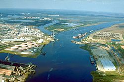
An aerial view of the Mobile River where it meets Chickasaw Creek. This photo was taken around 1990 during the building of the Cochrane-Africatown bridge.
-
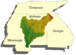
A map showing the Mobile River's drainage basin.


See also
 In Spanish: Río Mobile para niños
