George Wallace Tunnel facts for kids
 |
|
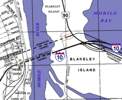
| Map of the Wallace (lower) and Bankhead (upper) tunnels under the Mobile River. | |
| Overview | |
|---|---|
| Location | Mobile River, Mobile, Alabama |
| Coordinates | 30°41′24″N 88°02′08″W / 30.69000°N 88.03556°W |
| Route | |
| Operation | |
| Traffic | 78,775 (2015) |
| Character | Dual four-lane road tunnel |
| Toll | none |
| Technical | |
| Length | 3,000 feet (914 m) |
| Number of lanes | 4 |
| Tunnel clearance | 16 feet (5 m) |
The George Wallace Tunnel is a pair of road tunnels in Mobile, Alabama. These tunnels carry Interstate 10 traffic. They go under the Mobile River and connect downtown Mobile to Blakeley Island. From there, the road joins the Jubilee Parkway over Mobile Bay.
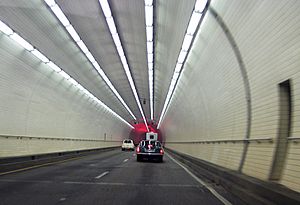
The tunnel was built between 1969 and 1973. It was constructed at the Alabama Drydock and Shipbuilding Company (ADDSCO) shipyards in Mobile. This is the same place where the smaller Bankhead Tunnel was built. The George Wallace Tunnel actually has two separate tubes. One tube is for two lanes of eastbound traffic, and the other is for two lanes of westbound traffic on Interstate 10.
Building the Tunnel
The George Wallace Tunnel was built using a special method. Large sections of the tunnel were made on land. Then, these sections were floated into the river. They were carefully moved into the correct positions and then sunk to the riverbed. Each new section was connected underwater to the one before it.
Once all the sections were joined, concrete was added to make them strong. After that, the water was pumped out of the tunnels. This made them dry and ready for the final touches. The tunnel provides 40 feet (12.2 meters) of clearance for ships above it. This means large ships can pass over the tunnel safely.
The tunnel officially opened to traffic on February 9, 1973. It cost about $50 million to build at that time. The tunnel was named after George Wallace, who was the Governor of Alabama when it was completed.
Tunnel Entrances
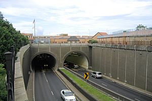
On the west side, the George C. Wallace Tunnel comes out under Royal Street in downtown Mobile. Unlike the Bankhead Tunnel, which comes out at street level, the Wallace Tunnel slopes upward. It becomes an elevated highway that continues Interstate 10 above the city streets.
On the eastern side, over Blakeley Island, the tunnel also slopes upward. It then becomes the elevated parts of I-10. These parts cross Mobile Bay to the east. They are part of the twin bridges of the curved I-10 Jubilee Parkway.
The western entrance of the tunnel has a sharp curve. This curve can cause long traffic jams, especially during busy times. Because of this, officials are looking into building a new way to cross the river.
Around the Tunnel Area
The area where the George C. Wallace Tunnel passes under downtown Mobile was later refilled. On top of this refilled land, a new version of Fort Conde was built. Several other new buildings were also constructed nearby. These buildings stretch from the Mobile River for several blocks.
Because the tunnel tubes come out within downtown Mobile, the riverbank looks smooth and continuous. You can't see any signs of the tunnels from the surface.
In Books
The author Michael Knight mentions the tunnel in one of his short stories. It's called "Our Lady of the Roses." He writes about a game that children in Mobile play. When they ride through the tunnel, they try to hold their breath for the entire trip.
 | Emma Amos |
 | Edward Mitchell Bannister |
 | Larry D. Alexander |
 | Ernie Barnes |


