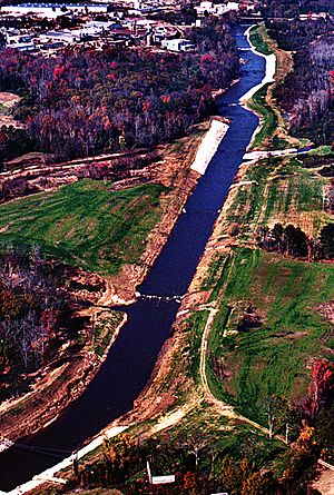
Luxapallila Creek facts for kids
Luxapalila Creek is a stream that flows for about 73.6 miles (118.4 kilometers) through the states of Mississippi and Alabama in the United States. Its name, Luxapalila, comes from the Choctaw language and means "flying turtle." This creek is an important part of the local environment, providing water for many areas.
Contents
What is Luxapalila Creek?
Luxapalila Creek is a long stream that starts in Alabama and flows into Mississippi. It is sometimes also spelled as Luxapallila Creek. The creek is a natural waterway that helps drain water from a large area of land.
Where Does the Creek Flow?
The creek drains a large area of land, known as a watershed, which covers about 803 square miles (2,080 square kilometers). This means all the rain and water that falls in this big area eventually flows into Luxapalila Creek.
The creek flows through several counties in both Alabama and Mississippi:
- In Alabama, it passes through Lamar County, Marion County, Fayette County, and Pickens County.
- In Mississippi, it flows through Monroe County and Lowndes County.
Cities Along the Creek
As it travels, Luxapalila Creek also runs through several cities. These include:
What Are Tributaries?
A tributary is a smaller stream or river that flows into a larger stream or river. Luxapalila Creek has several tributaries that feed water into it, making it larger as it flows.
Main Tributaries of Luxapalila Creek
Some of the important streams that flow into Luxapalila Creek are:
- Cut Bank Creek
- Hell's Creek
- Magby Creek
- Mud Creek
- Wilson Creek
- Yellow Creek
These smaller creeks help collect water from the surrounding land and bring it to Luxapalila Creek, which then continues its journey.
 | Delilah Pierce |
 | Gordon Parks |
 | Augusta Savage |
 | Charles Ethan Porter |


