
Etowah Indian Mounds facts for kids
|
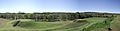
Etowah Mounds
|
|

Artist's conception of Etowah
|
|

Location in Metro Atlanta

Location in Georgia (U.S. state)

Location in the United States
|
|
| Nearest city | Cartersville, GA |
|---|---|
| NRHP reference No. | 66000272 |
Quick facts for kids Significant dates |
|
| Added to NRHP | October 15, 1966 |
| Designated NHL | July 19, 1964 |
The Etowah Indian Mounds are a huge 54-acre (about 220,000 square meters) archaeological site in Georgia, near the city of Cartersville. This ancient place was home to people for a long time, from about 1000 to 1550 CE (that's Common Era). It sits right on the north bank of the Etowah River.
Today, the Etowah Indian Mounds Historic Site is a special National Historic Landmark. It's looked after by the state of Georgia. Experts say it's "the most complete Mississippian culture site in the Southeast." Both the Muscogee Creek and Cherokee peoples, who lived here at different times, believe this site is very sacred.
Contents
Discovering Etowah's Past
Archaeologists started digging at Etowah in the early 1900s. They wanted to learn more about the people who lived here long ago. Over time, new tools like radiocarbon dating helped them understand the site better.
Studies in the late 1900s showed that the mounds were built by ancient indigenous peoples of the South Appalachian Mississippian culture. These people were ancestors of the Muscogee Creek people we know today.
The word Etowah comes from a Muscogee word, italwa, which means "town." From 1000 to 1550 CE, Etowah was a powerful center for different groups of people. The Spanish explorer Hernando de Soto might have visited a town called Itaba in this area in 1540.
Later, the Muscogee Creek people lived here. Then, the Cherokee moved into the area to escape European-American settlers. In the 1800s, many European-American settlers thought the Cherokee built the mounds. But we now know the Cherokee arrived much later. The mounds are much older than that.
Today, the Muscogee (Creek) Nation and the Poarch Band of Creek Indians both see Etowah as a very important ancestral town. The Cherokee also respect this special place.
When People Lived at Etowah
Scientists have studied pottery found at Etowah to figure out when people lived there. The town was used during three main periods:
- Around 1000–1200 CE
- Around 1250–1375 CE
- Around 1375–1550 CE
Etowah was most active and powerful between 1325 and 1375 CE.
Exploring the Etowah Mounds Site


Etowah has three large platform mounds and three smaller ones. The biggest, Mound A, is called the Temple Mound. It's 63 feet (about 19 meters) tall, which is taller than a six-story building! Its base covers 3 acres (about 12,000 square meters).
New studies in the 2000s showed that the site was even more complex than thought. Researchers found signs of 140 buildings. Mound A once had four main buildings and a courtyard at its peak. Mound B is 25 feet (about 7.6 meters) tall. Mound C is 10 feet (about 3 meters) tall and is the only one that has been fully dug up.
Archaeologists used special tools to find where temples made of logs and thatch once stood on top of the mounds. Next to the mounds is a flat, raised area called a ceremonial plaza. This was used for special events, games like stickball and chunkey, and as a market for trading goods.
When you visit Etowah, you can see the "borrow pits." These are big holes where workers dug up earth to build the mounds. People once thought these pits were moats around the town.
Older pottery found here suggests there was an even earlier village. This village was part of the Swift Creek culture and existed around 200 BCE to 600 CE. It might have been connected to the Leake Mounds site, which is nearby.
How Etowah Was Protected
The people of Etowah often fought with other groups, like those from Moundville in Alabama. To protect their town, they built a clever defense system.
First, they planted orchards of nut trees outside the town. This made it hard for enemies to shoot flaming arrows into the town. Then, a deep moat, about 9 to 10 feet (2.7 to 3 meters) deep, stopped enemies from reaching the walls directly. This moat also helped drain water during floods, which were common.
The town was surrounded by a strong palisade (a fence of tall logs). Workers set 12-foot (3.6-meter) high logs upright in a ditch. They packed earth around them to make a levee. Guard towers for archers were placed about every 80 feet (24 meters) along the wall.
Amazing Artifacts from Etowah

The items found in burials at Etowah show that its people had amazing artistic and technical skills. Many copper tools, weapons, and beautiful copper plates were buried with important people. Because copper helps preserve things, archaeologists also found colorful cloth with fancy patterns. These were the clothes of the leaders.
Over the years, many clay figures and ten stone statues have been found at Etowah. Many statues come in pairs: a man sitting cross-legged and a woman kneeling. The women wear skirts, and the men usually don't have visible clothes. Both often have fancy hairstyles. These pairs might represent important ancestors.
Other statues show young women kneeling with more details, possibly representing a fertility goddess or Earth Mother. Symbols like the birdman, a hand with an eye, and the solar cross appear on many artifacts from Etowah. These symbols are part of the Southeastern Ceremonial Complex, a shared set of beliefs and art among ancient Native American cultures.
Trade and Resources
The Etowah River was a busy waterway, connecting to the Coosa and Alabama rivers. This helped the people of Etowah trade with others. They got whelk shells from the Gulf of Mexico, and copper, mica, and flint from the Cumberland Plateau.
They also traded for galena, graphite, and different colors of ochre for painting buildings, bodies, and art. Greenstone and marble were brought in for tools, weapons, and special objects. The rich, fertile soil near the river was perfect for farming. It was refreshed every year by floods. The land was frost-free for most of the year, allowing for big harvests of corn, beans, and squash.
Plants and Animals of Etowah
The forests around Etowah were full of chestnut, walnut, hickory, and persimmon trees. These provided nuts and fruit for the people and for animals like white-tailed deer and wild turkey, which they hunted. Other plants gathered included stinging nettle and paper mulberry.
A native holly plant, Yaupon holly, was used to make a special drink called the Black drink. This was part of important purification ceremonies. River cane grew in thick patches and was used for arrow shafts, roof thatch, and weaving baskets, mats, and walls.
The river was also a great source of food. It had many freshwater mussels and turtles. The Mississippian people built V-shaped rock weirs in the river. These acted like traps, guiding fish like catfish, drum, and gar into baskets. More than 100 of these rock weirs have been found along the Etowah River. One has even been rebuilt at the historic site for visitors to see.
Etowah After European Contact
Archaeologists are still studying if the Etowah site is the same village that Spanish explorer Hernando de Soto visited in 1540. His records mention a town called Itaba. Some historians think the mounds might have been overgrown and not noticed by the Spanish. Itaba means "boundary" or "trail crossing" in the Alabama language. The English name Etowah comes from the Muscogee word Italwa, which means "town."
For a long time, many European-Americans in Georgia thought the Cherokee built Etowah. But the Cherokee didn't arrive in this part of Georgia until the late 1700s. This was hundreds of years after the mounds were built. Most experts now believe the mounds were built by the people of the South Appalachian Mississippian culture. These people are the ancestors of the Muscogee Creek people.
In the 1830s, most of the Creek people were forced to move to Indian Territory (now Oklahoma). Today, their descendants are part of two federally recognized tribes: the Muscogee (Creek) Nation in Oklahoma and the Poarch Band of Creek Indians in Alabama. Both tribes consider Italwa (Etowah) to be their most important ancestral town. The leader of the Creek Nation is even called Italwa Mikko, which means "Etowah Chief." A large model of Italwa is on display at the Muscogee (Creek) Capitol in Okmulgee, Oklahoma.
Studying the Mounds: A History


A missionary named Elias Cornelius visited the site in 1817. He wrote about it in his journal. He guessed that a mound was over 200 years old because of the big trees growing on it. Later, in 1883, Cyrus Thomas and John P. Rogan studied the site for the Smithsonian Institution.
The first big archaeological dig started in 1925, led by Warren K. Moorehead. His team dug into Mound C and found many amazing items buried with people from the Mississippian culture. These artifacts, along with others from places like Cahokia and Moundville, helped experts understand the Southeastern Ceremonial Complex (SECC). This dig greatly improved our knowledge of ancient Native American art.
Arthur R. Kelly, a professor from the University of Georgia, also led digs at Etowah. This was before the Allatoona Dam was built upstream in 1947 for flood control. In 1964, the Etowah site was named a National Historic Landmark.
The Etowah Indian Mounds museum at the site displays many artifacts. You can see pottery, stone axes, stone statues, copper jewelry, shell necklaces, and other items found there.
Images for kids
-
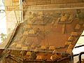
Model of Etowah at its height
-
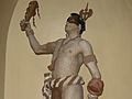
Statue of Etowah chief, Georgia State Capitol, based on archaeological findings and the descriptions of early European explorers
-
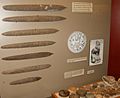
Ceremonial flint blades and chunkey stones
-
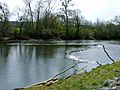
Rock fishing weir constructed on the Etowah River
-
Mounds B, and C from the top of Mound A.


More to Explore
