
Lake Allatoona facts for kids
Quick facts for kids Lake Allatoona |
|
|---|---|

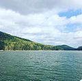
Seen from Red Top Mountain State Park
|
|

Lake Allatoona
Location in Georgia (U.S. state)

Lake Allatoona
Location in the United States
|
|
| Location | Georgia, United States |
| Coordinates | 34°8′18″N 84°38′38″W / 34.13833°N 84.64389°W |
| Type | reservoir |
| Primary inflows | Etowah River, Allatoona Creek, Little River, Noonday Creek |
| Primary outflows | Etowah River |
| Basin countries | United States |
| Surface area | 12,010 acres (48.6 km2) |
| Max. depth | 44.196 metres (145.00 ft) |
| Water volume | 367,500 acre⋅ft (0.4533 km3) |
| Surface elevation | 840 feet (260 m) |
| Islands | Seven Islands |
| Settlements | Cartersville, Emerson, Canton, and Acworth |
Lake Allatoona is a large lake in the northwestern part of Georgia. It was created by the United States Army Corps of Engineers and is mostly located in Bartow and Cherokee counties. A small part of the lake is in Cobb County, near Acworth.
The city closest to the Allatoona Dam is Cartersville. You can also find Red Top Mountain State Park on the lake's shores. This park is on a piece of land that sticks out into the lake. Much of the northern side of the lake is protected from new buildings. This is because its location is quite isolated, mostly surrounded by the lake itself.
Major roads like Interstate 75 and U.S. Highway 41 run along the southern and western sides of Lake Allatoona. They cross the Etowah River after it flows out of the Allatoona Dam.
Contents
Allatoona Dam: How the Lake Was Made
| Allatoona Dam | |
|---|---|
 |
|
|
Location of Allatoona Dam in Georgia (U.S. state)
|
|
| Country | United States |
| Location | Cartersville, Georgia |
| Coordinates | 34°09′50″N 84°43′41″W / 34.164°N 84.728°W |
| Purpose | Power, flood control, water supply, recreation |
| Status | Operational |
| Construction began | 1946 |
| Opening date | 1950 |
| Construction cost | US$31.5 million (Equivalent to US$387 million in 2026) |
| Owner(s) | |
| Dam and spillways | |
| Type of dam | Gravity |
| Impounds | Etowah River |
| Height | 190 ft (58 m) |
| Spillway capacity | 297,000 cu ft/s (8,410 m3/s) |
| Reservoir | |
| Creates | Lake Allatoona |
| Total capacity | 367,500 acre⋅ft (453,300,000 m3) |
| Catchment area | 1,110 sq mi (2,900 km2) |
| Surface area | 12,010 acres (48.6 km2) |
| Maximum water depth | 145 ft (44 m) |
| Power station | |
| Commission date | 1950 |
| Turbines | 3 |
| Installed capacity | 85 MW (114,000 hp) |
The Allatoona Dam is a concrete dam built on the Etowah River. It was approved in 1941 and 1944 to help control floods. Building the dam started in 1946, after World War II.
The lake began to fill with water in December 1949. The dam and its power station started working in January 1950. This power station can produce 85 megawatts of electricity. The United States Army Corps of Engineers owns and runs the dam.
How Lake Allatoona Works
Lake Allatoona serves many important purposes:
- Flood Control: It helps prevent flooding in areas downstream.
- Making Electricity: It generates hydroelectricity for homes and businesses.
- Water Supply: It provides drinking water to nearby communities.
- Recreation: It offers many fun activities for visitors.
- Fish and Wildlife: It helps manage and protect local fish and wildlife.
- Water Quality: It helps keep the water clean.
- Navigation: It helps with boat travel.
There are many private marinas and public boat ramps around the lake. These places make it easy for people to enjoy boating and other water sports.
Lake Allatoona provides much of the drinking water for the three counties it touches. The water mostly comes from the Etowah River. Other important streams that feed the lake include the Little River and Noonday Creek. The lake also gets water from Allatoona Creek, which flows into it near Acworth.
The area of land that drains water into Lake Allatoona is about 1,100 square miles (2,850 km2). This area is almost as big as the area that drains into Lake Lanier, another major water source in Georgia. Because Lake Allatoona is smaller, its water levels can change more quickly during droughts (when there's not enough rain) and floods (when there's too much rain).
The lake's water level in summer is usually about 840 feet (256 m) above sea level. During very dry periods, the water level can drop by as much as 13 feet (4 m). When this happens, you can sometimes see old tree stumps and hills that are usually deep underwater. The highest the lake can get is 863 feet (263 m) above sea level, but it has never reached this level. Even before it reaches this point, boat ramps and other lakeside facilities can start to flood.
The electricity made at Allatoona Dam brings in more than $3.5 million for the U.S. government each year. The Corps of Engineers also has 662 campsites around the lake for people to enjoy.
History of Lake Allatoona
The area around Lake Allatoona has a rich history. During the American Civil War, in June 1864, there was a fierce battle called the Battle of Allatoona at Allatoona Pass. More than 1,500 soldiers were killed, wounded, or went missing in this 8-hour fight.
The decision to build Lake Allatoona was made in 1941 and 1946. The town of Allatoona, Georgia was covered by water when the lake was created. Several roads were also changed or moved.
The total cost to build the Allatoona project, including land and moving things, was $31.5 million in 1950. The highest water level ever recorded on Lake Allatoona was 861.19 feet (262.49 m) on April 9, 1964.
People visiting Lake Allatoona spent over $12 million on goods in 1999. In 2006, the Corps of Engineers collected more than $1 million from camping and day-use fees.
The power plant at the dam started working on January 31, 1950. Since 1957, the lake's summer water level has been kept at 840 feet (256 m) above sea level. In winter, the water level is lowered to 823 feet (251 m) above sea level. Two cities, Cartersville and Cobb County-Marietta Water Authority, take water from the lake for their residents.
In the late 1980s, there was a long drought. The lake's water level dropped so much that you could see old tree stumps, roads, and even foundations of houses that were usually underwater. Grass grew in some places, and kids even played baseball on the newly exposed land!
In 1998, Lake Allatoona had more visitor hours than any of the other 450 Corps of Engineer projects in the United States. It had over 86 million visitor hours and even more in 2006, with over 92 million visitor hours.
Since 1950, the Allatoona Dam has prevented nearly $80 million in flood damages.
Fun Things to Do at Lake Allatoona
Marinas
There are eight private marinas around Lake Allatoona. These places offer fuel, boat storage, repairs, rentals, and supplies for boaters. There are also two yacht clubs, one near Kellogg Creek Road and another near Red Top Mountain State Park.
Boat Ramps
The Corps of Engineers provides fifteen public boat ramps around the lake. These ramps are located in Cobb, Cherokee, and Bartow counties. They are used for water sports, and some areas have picnic spots. Parking is available at these ramps.
Recreation
- Camping: The Corps of Engineers runs seven campgrounds and campsites around Lake Allatoona.
- Hunting: If you want to hunt, you need to follow the rules set by the state or local government. You also need a state hunting license to hunt on Corps of Engineers land.
Images for kids
-
Looking north toward Vineyard Mountain

