Noonday Creek facts for kids
Noonday Creek is a stream about 20 miles (32 km) long in Cobb and Cherokee counties in the U.S. state of Georgia. The stream starts near Kennesaw Mountain and flows into Lake Allatoona.
The name "Noonday" comes from the Cherokee language. It refers to the middle of the day, or solar noon.
Contents
Geography of Noonday Creek
Noonday Creek is a smaller stream that flows into a larger one, called a tributary. It joins the Little River inside Lake Allatoona. This meeting point is now under the water of the lake.
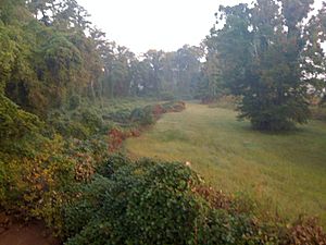
Near the northern part of Cobb County, Noonday Creek receives water from the Noonday Water Reclamation Facility. This facility is a plant that cleans water for Cobb and Cherokee counties before it goes back into the creek. A large pipe for cleaning water runs along most of the creek. You can often see it as a treeless area covered in kudzu plants, with concrete covers for access points.
Smaller Streams Joining Noonday Creek
Little Noonday Creek is the only officially named smaller stream that flows into Noonday Creek. It starts in Marietta and flows northwest, joining the main creek near Noonday Creek Park. Another unnamed stream flows from Lake Latimer to the north end of the park.
When it rains a lot, the main creek often floods the fields at the park. This happens more often now because of a lot of new buildings and roads in the area. These developments cause more rainwater to flow quickly into the creek.
Other smaller streams flow into Noonday Creek from places like Laura Lake, Chastain Lakes, Bells Ferry Park, Barrett Lakes, Ellison Lakes, Bozeman Lake (near Kennesaw State University), and Timber Lake.
Watching the Creek's Water Levels
There are two special measuring stations on Noonday Creek. These stations are called USGS stream gauges. They have been working since October 2000 and send information to GOES weather satellites.
One station is at Hawkins Store Road, at the south end of Noonday Creek Park. It measures the water level and flow. The other station is at Shallowford Road, further downstream (north) near the water treatment plant. This station also measures water level, flow, and has a rain gauge to measure rainfall.
These stations help people know how high the water is in the creek. A "minor flood stage" means the water is 10 feet (3 meters) deep at the Shallowford gauge. A "major flood stage" means it is 16 feet (4.9 meters) deep.
Flooding in Noonday Creek
Noonday Creek has experienced serious floods. Until 2009, the worst flood happened in July 2005. This was when heavy rains from Hurricane Dennis came just after Hurricane Cindy. A huge amount of rain fell in less than 24 hours. The creek reached a depth of 16.30 feet (4.97 meters) on July 10. This was about ten times its normal depth.
This flood went beyond what is called the 100-year flood plain. This means it was a very rare and severe flood. It happened partly because of a lot of building and development upstream. Many people did not have flood insurance because of this.
Record Flooding in September 2009
In September 2009, an even worse flood happened. A weather system stayed in the area, causing many heavy rain showers and thunderstorms. On September 21, the creek rose higher than it did in 2005.
The flood blocked major roads like Georgia 92 and Interstate 575. It also flooded the Towne Lake Parkway area. Traffic had to be sent on long detours, making it very hard for people to get home. Some people were stuck in traffic for hours.
The 2009 Atlanta floods were called "historic" by the local weather office. At Shallowford Road, Noonday Creek reached a record depth of 19.66 feet (6 meters). The amount of water flowing was extremely high, about 10,000 cubic feet (283 cubic meters) per second. This was after at least 17.5 inches (440 millimeters) of rain fell in one week. The flood also caused about $362,500 in damage to the water treatment facility.
Controlling Floods
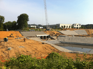
To help control flooding, a special facility was built. The Chastain Meadows Regional Stormwater Management Facility was completed on July 31, 2011.
Noonday Creek Structure Number 4
Noonday Creek Structure Number 4 is an earthen dam on Noonday Creek. Dams help control the flow of water and prevent floods.
Noonday Creek Structure Number 9
Noonday Creek Structure Number 9 is also known as Ellison Lake Dam. It is an earthen dam used to control floods. It was finished in 1955. This dam is 29 feet (8.8 meters) tall and 598 feet (182 meters) long.
Noonday Creek Structure Number 16
Noonday Creek Structure Number 16 is another earthen dam on Noonday Creek. It is considered a high-hazard dam and is regulated by the Georgia Safe Dams Program. It is located near Big Shanty Road in Kennesaw, GA. This dam was completed in 1956.
A soccer stadium and recreation areas for Kennesaw State University have been built around this dam.
Fun Things to Do Near Noonday Creek
Noonday Creek Trail
The Noonday Creek Trail is a path being built along the creek. Since many trees were already removed from this area, building the trail won't cause much more impact if it uses a surface that lets water soak through. The trail will eventually stretch along most of the creek in Cobb County.
Noonday Creek in History
Civil War History
Noonday Creek was an important waterway during the Battle of Noonday Creek in June and July 1864. This was a part of the American Civil War.
Early Uses of Water Power
In the past, Noonday Creek provided power for mills in the area. These mills used the flowing water to grind grain or saw wood, including near Woodstock.
 | James Van Der Zee |
 | Alma Thomas |
 | Ellis Wilson |
 | Margaret Taylor-Burroughs |


