Yatesville, Georgia facts for kids
Quick facts for kids
Yatesville, Georgia
|
|
|---|---|
| Nickname(s):
The Red Dirt City
|
|

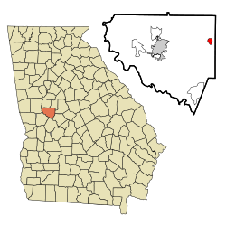
Location in Upson County and the state of Georgia
|
|
| Country | United States |
| State | Georgia |
| County | Upson |
| Area | |
| • Total | 0.88 sq mi (2.27 km2) |
| • Land | 0.86 sq mi (2.24 km2) |
| • Water | 0.01 sq mi (0.03 km2) |
| Elevation | 797 ft (243 m) |
| Population
(2020)
|
|
| • Total | 394 |
| • Density | 456.55/sq mi (176.21/km2) |
| Time zone | UTC-5 (Eastern (EST)) |
| • Summer (DST) | UTC-4 (EDT) |
| ZIP code |
31097
|
| Area code(s) | 706 |
| FIPS code | 13-84708 |
| GNIS feature ID | 0325604 |
Yatesville is a small town located in Upson County, Georgia, in the United States. In 2020, about 394 people lived there.
History of Yatesville
Yatesville was started in 1888. This happened when a railroad line was built to reach that area. The town was named after A.J. Yates, who was one of the first people to settle there. A few years later, in 1896, the Georgia General Assembly officially made Yatesville a town. This means it became a recognized place with its own local government.
Geography and Location
Yatesville is found at coordinates 32.912663 degrees North and -84.142393 degrees West.
The town is located along Georgia State Route 74. This road goes through the middle of Yatesville from west to east. If you travel east on GA-74, you will reach Macon, which is about 35 miles (56 km) away. If you go west, you will get to Thomaston, which is the main city of Upson County, about 12 miles (19 km) away.
According to the United States Census Bureau, Yatesville covers a total area of about 0.9 square miles (2.27 square kilometers). Most of this area is land, with a very small part (about 1.14%) being water.
Population and People
| Historical population | |||
|---|---|---|---|
| Census | Pop. | %± | |
| 1900 | 283 | — | |
| 1910 | 366 | 29.3% | |
| 1920 | 400 | 9.3% | |
| 1930 | 281 | −29.7% | |
| 1940 | 240 | −14.6% | |
| 1950 | 290 | 20.8% | |
| 1960 | 354 | 22.1% | |
| 1970 | 423 | 19.5% | |
| 1980 | 390 | −7.8% | |
| 1990 | 409 | 4.9% | |
| 2000 | 408 | −0.2% | |
| 2010 | 357 | −12.5% | |
| 2020 | 394 | 10.4% | |
| U.S. Decennial Census 1850-1870 1880 1890-1910 1920-1930 1930-1940 1940-1950 1960-19801990 |
|||
In 2000, there were 408 people living in Yatesville. These people lived in 158 households, and 124 of these were families. The town had about 465 people per square mile (179 people per square kilometer). There were also 175 housing units, which are homes or apartments.
The people living in Yatesville came from different backgrounds. Most residents were White, and a good number were African American. A small percentage were Native American or from other backgrounds. Some residents were also of Hispanic or Latino origin.
About 30.8% of the households had children under 18 years old living with them. Many households (58.5%) were married couples. About 19.5% of households were individuals living alone.
The age of people in Yatesville varied. About 21.8% of the population was under 18 years old. About 29.2% were between 25 and 44 years old. The average age in the town was 39 years.
The average income for a household in Yatesville was about $38,750 per year. For families, the average income was around $38,500. About 9.4% of the people in Yatesville lived below the poverty line. This included about 16.5% of those under 18 years old.
See also
 In Spanish: Yatesville (Georgia) para niños
 | Shirley Ann Jackson |
 | Garett Morgan |
 | J. Ernest Wilkins Jr. |
 | Elijah McCoy |

