Lamar County, Georgia facts for kids
Quick facts for kids
Lamar County
|
||
|---|---|---|

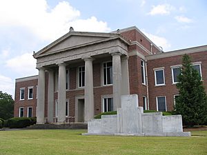
Lamar County courthouse in Barnesville
|
||
|
||

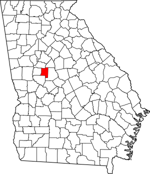
Location within the U.S. state of Georgia
|
||
 Georgia's location within the U.S. |
||
| Country | ||
| State | ||
| Founded | 1920 | |
| Named for | Lucius Quintus Cincinnatus Lamar II | |
| Seat | Barnesville | |
| Largest city | Barnesville | |
| Area | ||
| • Total | 186 sq mi (480 km2) | |
| • Land | 184 sq mi (480 km2) | |
| • Water | 2.3 sq mi (6 km2) 1.3%% | |
| Population
(2020)
|
||
| • Total | 18,500 | |
| • Density | 101/sq mi (39/km2) | |
| Time zone | UTC−5 (Eastern) | |
| • Summer (DST) | UTC−4 (EDT) | |
| Congressional district | 3rd | |
Lamar County is a cool place located in the West Central part of Georgia. It's a county, which is like a smaller area within a state. In 2020, about 18,500 people lived here. The main town, or county seat, where the government offices are, is Barnesville.
Contents
History of Lamar County
Lamar County was officially created in 1920. The idea to form the county came from the Georgia General Assembly, which is like Georgia's state government. They suggested a change to the state's rules on August 17, 1920.
People in Georgia then voted on this change on November 2, 1920, and they said yes! To make the new county, land was taken from two nearby counties: Pike County and Monroe County. Lamar County got its name from a person named Lucius Quintus Cincinnatus Lamar II.
Geography of Lamar County
Lamar County covers about 186 square miles. Most of this area, about 184 square miles, is land. The rest, about 2.3 square miles, is water. This means about 1.3% of the county is water.
The county is located in the Piedmont region of Georgia. This region is known for its rolling hills and is between the mountains and the flatter coastal plains.
Rivers and Basins
The western part of Lamar County has rivers that flow into the Upper Flint River. This river is part of a larger system called the ACF River Basin. The eastern part of the county has rivers that flow into the Upper Ocmulgee River. This river is part of the Altamaha River basin.
Major Highways in Lamar County
Getting around Lamar County is easy with several important roads. These highways connect the county to other parts of Georgia and beyond.
Counties Next to Lamar County
Lamar County shares its borders with several other counties in Georgia:
- Butts County (to the northeast)
- Monroe County (to the east)
- Upson County (to the southwest)
- Pike County (to the west)
- Spalding County (to the northwest)
Communities in Lamar County
Lamar County has a few towns and cities where people live and work.
Cities
- Barnesville (This is the main city and the county seat.)
- Milner
Towns
- Aldora
- Goggins
Population of Lamar County
| Historical population | |||
|---|---|---|---|
| Census | Pop. | %± | |
| 1930 | 9,745 | — | |
| 1940 | 10,091 | 3.6% | |
| 1950 | 10,242 | 1.5% | |
| 1960 | 10,240 | 0.0% | |
| 1970 | 10,688 | 4.4% | |
| 1980 | 12,215 | 14.3% | |
| 1990 | 13,038 | 6.7% | |
| 2000 | 15,912 | 22.0% | |
| 2010 | 18,317 | 15.1% | |
| 2020 | 18,500 | 1.0% | |
| 2023 (est.) | 20,401 | 11.4% | |
| U.S. Decennial Census 1790-1880 1890-1910 1920-1930 1930-1940 1940-1950 1960-1980 1980-2000 2010 2020 |
|||
The population of Lamar County has grown over the years. In 2020, there were 18,500 people living here. These people lived in about 6,494 households, and 3,746 of those were families.
Education in Lamar County
All the schools in Lamar County are part of one school system. This is called the Lamar County School District.
See also
 In Spanish: Condado de Lamar (Georgia) para niños
 | Chris Smalls |
 | Fred Hampton |
 | Ralph Abernathy |


