
Spalding County, Georgia facts for kids
Quick facts for kids
Spalding County
|
||
|---|---|---|
.JPG)
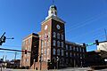
Spalding County Courthouse in Griffin
|
||
|
||

Location within the U.S. state of Georgia
|
||
 Georgia's location within the U.S. |
||
| Country | ||
| State | ||
| Founded | 1851 | |
| Named for | Thomas Spalding | |
| Seat | Griffin | |
| Largest city | Griffin | |
| Area | ||
| • Total | 200 sq mi (500 km2) | |
| • Land | 196 sq mi (510 km2) | |
| • Water | 3.1 sq mi (8 km2) 1.6%% | |
| Population
(2020)
|
||
| • Total | 67,306 | |
| Time zone | UTC−5 (Eastern) | |
| • Summer (DST) | UTC−4 (EDT) | |
| Congressional district | 3rd | |
Spalding County is a county located in the U.S. state of Georgia. It is found in the West Central part of the state. In 2020, about 67,306 people lived there.
The main city and government center of the county is Griffin. Spalding County was created on December 20, 1851. It was named after Thomas Spalding. He was a person who served in the U.S. House of Representatives and the U.S. Senate. Spalding County is also part of the larger Atlanta-Sandy Springs-Roswell area.
Contents
What is the Geography of Spalding County?
Spalding County covers a total area of 200 square miles. Most of this area, about 196 square miles, is land. The remaining 3.1 square miles, which is about 1.6%, is water. The county is located in a region of Georgia called the Piedmont.
The western part of Spalding County is in the Upper Flint River area. This includes towns like Sunny Side, Griffin, and Orchard Hill. The eastern part of the county is in the Upper Ocmulgee River area.
What Major Roads Go Through Spalding County?
Many important roads help people travel through Spalding County. These roads connect the county to other parts of Georgia and the United States.
 Interstate 75
 U.S. Route 19
U.S. Route 19 Business U.S. Route 41
U.S. Route 41 Business State Route 3
 State Route 7
 State Route 16
 State Route 92
 State Route 155
 State Route 362
 State Route 401 (This is the official name for I-75)
Which Counties are Next to Spalding County?
Spalding County shares its borders with several other counties in Georgia.
- Henry County (to the northeast)
- Butts County (to the east)
- Lamar County (to the southeast)
- Pike County (to the southwest)
- Meriwether County (to the west)
- Coweta County (to the west)
- Fayette County (to the northwest)
- Clayton County (to the northwest)
What are the Towns and Cities in Spalding County?
Spalding County has a few main communities where people live.
Cities
- Griffin (This is the county seat, meaning it's where the county government is located)
- Sunny Side
Town
Census-Designated Places
These are areas that are like towns but are not officially incorporated as cities or towns.
How Has the Population of Spalding County Changed?
The number of people living in Spalding County has grown over many years. Here is a look at the population from different census counts.
| Historical population | |||
|---|---|---|---|
| Census | Pop. | %± | |
| 1860 | 8,699 | — | |
| 1870 | 10,205 | 17.3% | |
| 1880 | 12,585 | 23.3% | |
| 1890 | 13,117 | 4.2% | |
| 1900 | 17,619 | 34.3% | |
| 1910 | 19,741 | 12.0% | |
| 1920 | 21,908 | 11.0% | |
| 1930 | 23,495 | 7.2% | |
| 1940 | 28,427 | 21.0% | |
| 1950 | 31,045 | 9.2% | |
| 1960 | 35,404 | 14.0% | |
| 1970 | 39,514 | 11.6% | |
| 1980 | 47,899 | 21.2% | |
| 1990 | 54,457 | 13.7% | |
| 2000 | 58,417 | 7.3% | |
| 2010 | 64,073 | 9.7% | |
| 2020 | 67,306 | 5.0% | |
| 2023 (est.) | 69,946 | 9.2% | |
| U.S. Decennial Census 1790-1880 1890-1910 1920-1930 1930-1940 1940-1950 1960-1980 1980-2000 2010 2020 |
|||
In 2020, there were 67,306 people living in Spalding County. There were 25,339 households and 16,563 families.
What About Education in Spalding County?
The Griffin-Spalding County School District is in charge of public education. It has many schools for students of all ages.
- 11 elementary schools (for younger students)
- 4 middle schools (for students around your age)
- 2 high schools (for older students)
- 4 special programs that help students in different ways
Images for kids
-
The Spalding County Courthouse in Griffin.
See also
 In Spanish: Condado de Spalding para niños
