Clayton County, Georgia facts for kids
Quick facts for kids
Clayton County
|
|||
|---|---|---|---|

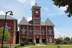
Clayton County Courthouse in Jonesboro
|
|||
|
|||

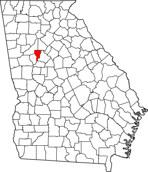
Location within the U.S. state of Georgia
|
|||
 Georgia's location within the U.S. |
|||
| Country | |||
| State | |||
| Founded | November 30, 1858 | ||
| Named for | Augustin Smith Clayton | ||
| Seat | Jonesboro | ||
| Largest city | Forest Park | ||
| Area | |||
| • Total | 144 sq mi (370 km2) | ||
| • Land | 142 sq mi (370 km2) | ||
| • Water | 2.8 sq mi (7 km2) 1.9%% | ||
| Population
(2020)
|
|||
| • Total | 297,595 | ||
| • Estimate
(2023)
|
298,300 |
||
| • Density | 2,101/sq mi (811/km2) | ||
| Time zone | UTC−5 (Eastern) | ||
| • Summer (DST) | UTC−4 (EDT) | ||
| Congressional districts | 5th, 13th | ||
Clayton County is a county in the north central part of Georgia, USA. In 2020, about 297,595 people lived here. The main town, or county seat, is Jonesboro.
Clayton County is a key part of the larger Atlanta metropolitan area. It is the fifth most populated county in Georgia. A big part of Hartsfield–Jackson Atlanta International Airport is located here. This airport is known as the busiest airport in the world for how many passengers it serves.
Contents
History of Clayton County
Clayton County was created in 1858. It was named after Augustin Smith Clayton (1783–1839). He was a politician who served in the United States House of Representatives.
During the American Civil War, some important battles happened in Clayton County. These included the Battle of Jonesborough and the Battle of Lovejoy's Station.
Geography and Rivers
Clayton County covers about 144 square miles (373 square kilometers). Most of this area is land, with a small part being water. It is the third smallest county in Georgia by land area.
The eastern side of the county is near the Upper Ocmulgee River. The western side is near the Upper Flint River. These rivers are important parts of larger river systems in the region.
Neighboring Counties
Clayton County shares borders with these other counties:
- DeKalb County (to the northeast)
- Henry County (to the east)
- Spalding County (to the south)
- Fayette County (to the southwest)
- Fulton County (to the northwest)
Towns and Communities
Clayton County has several towns and communities.
Cities in Clayton County
Other Communities
Some areas are called Census-designated places, which are like towns but not officially cities:
There are also other smaller communities that are not officially part of a city:
People of Clayton County
| Historical population | |||
|---|---|---|---|
| Census | Pop. | %± | |
| 1860 | 4,466 | — | |
| 1870 | 5,477 | 22.6% | |
| 1880 | 8,027 | 46.6% | |
| 1890 | 8,295 | 3.3% | |
| 1900 | 9,598 | 15.7% | |
| 1910 | 10,453 | 8.9% | |
| 1920 | 11,159 | 6.8% | |
| 1930 | 10,260 | −8.1% | |
| 1940 | 11,655 | 13.6% | |
| 1950 | 22,872 | 96.2% | |
| 1960 | 46,365 | 102.7% | |
| 1970 | 98,043 | 111.5% | |
| 1980 | 150,357 | 53.4% | |
| 1990 | 182,052 | 21.1% | |
| 2000 | 236,517 | 29.9% | |
| 2010 | 259,424 | 9.7% | |
| 2020 | 297,595 | 14.7% | |
| 2023 (est.) | 298,300 | 15.0% | |
| U.S. Decennial Census 1790-1880 1890-1910 1920-1930 1930-1940 1940-1950 1960-1980 1980-2000 2010 2020 |
|||
In 2020, Clayton County had 297,595 residents. There were about 97,030 households. The population has grown a lot over the years. For example, in 1980, there were about 150,000 people.
The people living in Clayton County come from many different backgrounds. In 2020, most residents identified as Black or African American. There are also many people who identify as White, Asian, Native American, or from other racial groups. A significant number of residents are of Hispanic or Latino origin.
The average income for a household in Clayton County was about $43,311 in 2010. This means that half of the households earned more than this amount, and half earned less.
Economy and Jobs
In November 2019, the unemployment rate in Clayton County was 3.4%. This means a small percentage of people looking for jobs could not find them. Experts predict that the number of jobs in the county will grow by almost 30% over the next ten years.
When you buy things in Clayton County, there is an 8.00% sales tax. The income tax rate is 6.00%. The average income per person, including adults and children, is about $18,735.
Education in Clayton County
Clayton County has its own public school system, called Clayton County Public Schools.
School System Challenges
In 2008, the Clayton County school system faced a big challenge. It lost its "accreditation" from an organization called the Southern Association of Colleges and Schools (SACS). Accreditation means a school system meets certain quality standards. This was a rare event for a school system of its size.
The main issue was that the school board was not following its own rules. There were concerns about how contracts were given out. Leaders in the county called for changes to the school board. The school system worked hard to fix these problems.
By May 2009, the Clayton County Public School System successfully got its accreditation back from SACS. This showed they had improved and met the necessary standards again.
Colleges and Universities
Clayton State University is a college located in Morrow, within Clayton County.
Getting Around Clayton County
Airports
The county is home to Hartsfield-Jackson Atlanta International Airport. This is one of the busiest airports in the world.
Main Roads
Many important highways run through Clayton County, connecting it to other parts of Georgia and beyond. These include:
 Interstate 75
 Interstate 85
 Interstate 285
 Interstate 675
 U.S. Route 19
 U.S. Route 23
 U.S. Route 29
 U.S. Route 41
 State Route 3
 State Route 3 Connector
 State Route 42
 State Route 54
 State Route 85
 State Route 138
 State Route 138 Spur
 State Route 139
 State Route 314
 State Route 331
 State Route 401 (unsigned designation for I-75)
 State Route 403 (unsigned designation for I-85)
 State Route 407 (unsigned designation for I-285)
 State Route 413 (unsigned designation for I-675)
Public Transport
Buses from MARTA and Xpress GA serve the county. These help people travel without needing a car.
There are also plans for a new train service in Clayton County. This train would have stops in Forest Park, Morrow, Jonesboro, and Lovejoy. The Metropolitan Atlanta Rapid Transit Authority's Airport train station is already located in Clayton County.
Walking and Biking Paths
Clayton County has trails for walking and cycling, such as:
- Jesters Creek Trail
- Morrow Trail
- Clayton Connects
See also
In Spanish: Condado de Clayton (Georgia) para niños
 | Victor J. Glover |
 | Yvonne Cagle |
 | Jeanette Epps |
 | Bernard A. Harris Jr. |


