Fulton County, Georgia facts for kids
Quick facts for kids
Fulton County
|
|||
|---|---|---|---|
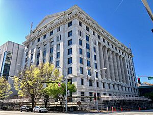
Atlanta's Fulton County Courthouse in 2019
|
|||
|
|||
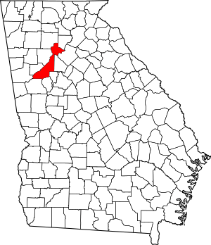
Location within the U.S. state of Georgia
|
|||
 Georgia's location within the U.S. |
|||
| Country | |||
| State | |||
| Founded | December 20, 1853 | ||
| Named for | Robert Fulton | ||
| Seat | Atlanta | ||
| Largest city | Atlanta | ||
| Area | |||
| • Total | 534 sq mi (1,380 km2) | ||
| • Land | 527 sq mi (1,360 km2) | ||
| • Water | 7.7 sq mi (20 km2) 1.4%% | ||
| Population
(2020)
|
|||
| • Total | 1,066,710 | ||
| • Estimate
(2023)
|
1,079,105 |
||
| • Density | 1,997.6/sq mi (771.3/km2) | ||
| Time zone | UTC−5 (Eastern) | ||
| • Summer (DST) | UTC−4 (EDT) | ||
| Congressional districts | 5th, 6th, 11th, 13th | ||
Fulton County is a county in the middle of Georgia, towards the north. In 2020, over 1 million people lived here, making it the county with the most people in Georgia. Its main city and capital is Atlanta, which is also the state capital. Most of Atlanta (about 90%) is in Fulton County. The rest of the city is in DeKalb County. Fulton County is the most important county in the larger Atlanta metropolitan area.
Contents
History of Fulton County

Fulton County was created in 1853. It was formed from the western part of DeKalb County. The county was named after Hamilton Fulton, who was a surveyor for the Western and Atlantic Railroad. Some people used to think it was named after Robert Fulton, who invented the steamboat, but that was incorrect.
As more people moved to the Piedmont area of Georgia, Fulton County grew quickly. This happened especially after the American Civil War. Atlanta was rebuilt and became a major center for shipping by train, industry, and business.
In 1932, during the Great Depression, two nearby counties joined Fulton County. These were Milton County to the north and Campbell County to the southwest. This made Fulton County very long, stretching about 80 miles (129 km) along the Chattahoochee River. Later that year, Cobb County gave the city of Roswell and some land to Fulton County. This made Fulton County's shape more connected.
In the late 1900s, many big companies set up their main offices in Atlanta and Fulton County. This brought many new workers from all over the country. Because of this, the city and county became more diverse and connected to the rest of the world.
Geography of Fulton County
Fulton County covers a total area of 534 square miles (1,383 km²). About 527 square miles (1,365 km²) is land, and 7.7 square miles (20 km²) is water. The county's shape looks a bit like a sword. The "handle" is in the northeast, and the "tip" is in the southwest.
The northern part of Fulton County, including Milton and northern Alpharetta, is in the Etowah River area. This river flows into the Coosa-Tallapoosa River Basin. The middle part of Fulton County, down to downtown Atlanta, is in the Upper Chattahoochee River area. This river flows into the Apalachicola-Chattahoochee-Flint River Basin.
Most of southern Fulton County, from Atlanta to Palmetto, is also in the Middle Chattahoochee River area. The eastern edges of south Fulton, from Palmetto to Hapeville, are in the Upper Flint River area. All these rivers are part of the larger Apalachicola-Chattahoochee-Flint River Basin.
Counties Next to Fulton County
- Cherokee County – northwest
- Forsyth County – northeast
- Gwinnett County – east
- DeKalb County – east
- Clayton County – south
- Fayette County – south
- Coweta County – southwest
- Carroll County – west
- Douglas County – west
- Cobb County – west
Protected Natural Areas
- Chattahoochee River National Recreation Area (part of it)
- Martin Luther King, Jr. National Historic Site
Communities in Fulton County
Cities
- Alpharetta
- Atlanta
- Chattahoochee Hills
- College Park
- East Point
- Fairburn
- Hapeville
- Johns Creek
- Milton
- Mountain Park
- Palmetto
- Roswell
- Sandy Springs
- South Fulton
- Union City
Unincorporated Communities
These are places that are not officially part of a city.
- Birmingham (now in Milton)
- Campbellton (now in South Fulton)
- Ocee (now in Johns Creek)
- Red Oak (now in South Fulton)
- Rico (now in Chattahoochee Hills)
- Sandtown (now in South Fulton)
- Serenbe (a village in Chattahoochee Hills)
- Shakerag (in Johns Creek)
- Warsaw (now in Johns Creek)
People of Fulton County
| Historical population | |||
|---|---|---|---|
| Census | Pop. | %± | |
| 1860 | 14,427 | — | |
| 1870 | 33,446 | 131.8% | |
| 1880 | 49,137 | 46.9% | |
| 1890 | 84,655 | 72.3% | |
| 1900 | 117,363 | 38.6% | |
| 1910 | 177,733 | 51.4% | |
| 1920 | 232,606 | 30.9% | |
| 1930 | 318,587 | 37.0% | |
| 1940 | 392,886 | 23.3% | |
| 1950 | 473,572 | 20.5% | |
| 1960 | 556,326 | 17.5% | |
| 1970 | 607,592 | 9.2% | |
| 1980 | 589,904 | −2.9% | |
| 1990 | 648,951 | 10.0% | |
| 2000 | 816,006 | 25.7% | |
| 2010 | 920,581 | 12.8% | |
| 2020 | 1,066,710 | 15.9% | |
| 2023 (est.) | 1,079,105 | 17.2% | |
| U.S. Decennial Census 1790-1880 1890-1910 1920-1930 1930-1940 1940-1950 1960-1980 1980-2000 2010 2020 |
|||
| Race / Ethnicity (NH = Non-Hispanic) | Pop 2000 | Pop 2010 | Pop 2020 | % 2000 | % 2010 | % 2020 |
|---|---|---|---|---|---|---|
| White alone (NH) | 369,997 | 376,014 | 404,793 | 45.34% | 40.85% | 37.95% |
| Black or African American alone (NH) | 361,018 | 400,457 | 448,803 | 44.24% | 43.50% | 42.07% |
| Native American or Alaska Native alone (NH) | 1,148 | 1,586 | 1,558 | 0.14% | 0.17% | 0.15% |
| Asian alone (NH) | 24,635 | 51,304 | 80,632 | 3.02% | 5.57% | 7.56% |
| Pacific Islander alone (NH) | 261 | 287 | 381 | 0.03% | 0.03% | 0.04% |
| Other race alone (NH) | 1,599 | 2,582 | 6,444 | 0.20% | 0.28% | 0.60% |
| Mixed race or Multiracial (NH) | 9,292 | 15,785 | 37,797 | 1.14% | 1.71% | 3.54% |
| Hispanic or Latino (any race) | 48,056 | 72,566 | 86,302 | 5.89% | 7.88% | 8.09% |
| Total | 816,006 | 920,581 | 1,066,710 | 100.00% | 100.00% | 100.00% |
In 2020, the U.S. Census counted 1,066,710 people living in Fulton County. There were 439,578 households and 238,444 families. The county has almost always seen its population grow, except for a small dip in 1980.
The people living in Fulton County come from many different backgrounds. In 2020, the largest groups were Black or African Americans (42.07%) and non-Hispanic whites (37.95%). There were also significant numbers of Asian Americans (7.56%) and Hispanic or Latino people (8.09%).
In 2022, the average household income was about $90,346. The average income per person was $59,689. About 12.7% of the people in the county lived at or below the poverty line.
Economy of Fulton County

Many well-known companies have their main offices in Fulton County. These include:
- AFC Enterprises (known for Popeyes Chicken and Cinnabon)
- AT&T Mobility
- Chick-fil-A
- Children's Healthcare of Atlanta
- Church's Texas Chicken
- The Coca-Cola Company
- Cox Enterprises
- Delta Air Lines
- Earthlink
- Equifax
- First Data
- Georgia-Pacific
- Global Payments, Inc.
- InterContinental Hotels Group
- IBM Internet Security Systems
- Mirant Corp.
- Newell Rubbermaid
- Northside Hospital
- Piedmont Healthcare
- Porsche Cars North America
- Saint Joseph's Hospital
- Southern Company
- United Parcel Service (UPS)
These companies are located in different cities throughout Fulton County.
Education in Fulton County
If you live in Fulton County but outside the city of Atlanta, you would go to schools run by the Fulton County School System. If you live inside the city limits of Atlanta, your schools are part of Atlanta Public Schools.
Libraries in Fulton County
History of Libraries
The Atlanta-Fulton County Library system started in 1902. It was first called the Carnegie Library of Atlanta. It was one of the first public libraries in the United States. In 1935, the city of Atlanta and Fulton County agreed to provide library services to everyone in the county.
Later, in 1982, people in Georgia voted to move the library system's control from the city of Atlanta to the county. On July 1, 1983, this change became official. The system was then renamed the Atlanta-Fulton Public Library System.
Under the leadership of Ella Gaines Yates, the first African American director, a new main library building opened in May 1988. The building was designed by Marcel Breuer, a famous architect. He worked with his partner Hamilton Smith. The Central Library was officially opened on May 25, 1980. Breuer passed away a year later in July 1981.
In 2002, after 100 years of serving the public, the Central Library was updated and renovated.
Transportation in Fulton County
Many major highways and interstate highways in the Atlanta area pass through Fulton County. Outside of Atlanta itself, Georgia 400 is a main highway in north Fulton. Interstate 85 is important in the southwest.
Major Highways
Interstate Highways
U.S. Highways
State Routes
 State Route 3
 State Route 3 Connector
 State Route 6
 State Route 8
 State Route 9
 State Route 10
 State Route 13
 State Route 14
 State Route 14 Alternate
 State Route 14 Connector
 State Route 42
 State Route 42 Connector
 State Route 42 Spur
 State Route 54
 State Route 54 Connector
 State Route 70
 State Route 74
 State Route 92
 State Route 120
 State Route 138
 State Route 139
 State Route 140
 State Route 141
 State Route 154
 State Route 154 Connector
 State Route 166
 State Route 236
 State Route 237
 State Route 279
 State Route 280
 State Route 372
 State Route 400
 State Route 401 (unsigned designation for I-75)
 State Route 402 (unsigned designation for I-20)
 State Route 403 (unsigned designation for I-85)
 State Route 407 (unsigned designation for I-285)
Other Important Roads
- Abernathy Road
- East Wesley Road
- Freedom Parkway (Georgia 10)
- Glenridge Drive
- Hammond Drive
- Johnson Ferry Road
- Lindbergh Drive (Georgia 236)
- Memorial Drive (Georgia 154)
- Moreland Avenue (U.S. 23/Georgia 42)
- Mount Vernon Highway
- Peachtree Road (Georgia 141)
- Peachtree-Dunwoody Road
- Piedmont Road (Georgia 237)
- Ponce de Leon Avenue (U.S. 23/29/78/278/Georgia 8/10)
- Powers Ferry Road
- Roswell Road (U.S. 19/Georgia 9)
- Windsor Parkway
Public Transportation
The MARTA system serves most of Fulton County. Fulton County, along with Clayton and DeKalb counties, pays a 1% sales tax to help fund MARTA. MARTA train service in Fulton County is currently available in Atlanta, Sandy Springs, East Point, College Park, and at the airport.
MARTA bus service covers most of the rest of the county. However, it does not reach the very rural areas in the far southwest or Johns Creek. People in North Fulton have asked for the train service to be extended about 10 miles (16 km) up the Georgia 400 corridor, from Perimeter Center to Alpharetta. But because Georgia's state government does not fund MARTA, there isn't enough money to expand the system. The sales taxes collected now are used to operate, maintain, and update the current system.
Xpress GA/RTA also provides commuter bus service. These buses take people from the outer suburbs of Fulton County, like Sandy Springs, to Midtown and Downtown Atlanta.
Recreational Trails
- BeltLine (still being built)
- Big Creek Greenway (still being built)
- PATH400 (still being built)
- Peachtree Creek Greenway (still being built)
Airports
Hartsfield-Jackson Atlanta International Airport is partly in Fulton County and partly in Clayton County to the south. It is the busiest airport in the world.
The Fulton County Airport, also known as Charlie Brown Field, is just west-southwest of Atlanta's city limit. The county runs this airport for smaller planes, like business jets and private aircraft.
See also
 In Spanish: Condado de Fulton (Georgia) para niños
 | Janet Taylor Pickett |
 | Synthia Saint James |
 | Howardena Pindell |
 | Faith Ringgold |


