
Sandy Springs, Georgia facts for kids
Quick facts for kids
Sandy Springs
|
|||
|---|---|---|---|

The contemporary skyline of Sandy Springs is dominated by the Concourse office towers, as seen in 2013.
|
|||
|
|||
| Country | United States | ||
| State | Georgia | ||
| County | Fulton | ||
| Incorporated | December 2005 | ||
| Area | |||
| • Total | 38.52 sq mi (99.77 km2) | ||
| • Land | 37.66 sq mi (97.53 km2) | ||
| • Water | 0.86 sq mi (2.24 km2) | ||
| Elevation | 1,093 ft (333 m) | ||
| Population
(2020)
|
|||
| • Total | 108,080 | ||
| • Rank | 290th in the United States 7th in Georgia |
||
| • Density | 2,870.04/sq mi (1,108.14/km2) | ||
| Time zone | UTC−5 (EST) | ||
| • Summer (DST) | UTC−4 (EDT) | ||
| ZIP Codes |
30319, 30327–30328, 30338, 30342, 30350, 30358, 30092
|
||
| Area code | 404/678/770/470 | ||
| FIPS code | 13-68516 | ||
| GNIS feature ID | 0332975 | ||
Sandy Springs is a city in northern Fulton County, Georgia, United States. It is a suburb of Atlanta. In 2020, about 108,080 people lived there. This makes it the 7th largest city in Georgia. Many big companies have their main offices in Sandy Springs. These include UPS, Newell Brands, and Mercedes-Benz USA.
Contents
History of Sandy Springs
People have lived in the Sandy Springs area for a very long time. Around 400 CE, Native Americans made trails to reach the fresh springs. Later, the Creek Muskogee tribe lived here until the early 1800s. They left when gold was found in the area.
In 1821, the government sold land in Sandy Springs. This led to more people settling there. The oldest house still standing was built in 1842. In 1851, Wilson Spruill gave land for the Sandy Springs United Methodist Church. The city is named after the natural spring near this church. In 1905, the Hammond School was built nearby.
Sandy Springs in the 20th Century
In 1950, the state stopped Atlanta from taking over Sandy Springs. The area stayed mostly rural. This changed when new highways, Georgia 400 and Interstate 285, were built in the early 1960s. These roads connected Sandy Springs to metro Atlanta. This led to a big increase in homes and new developments.
Atlanta tried to annex Sandy Springs again in 1959 and 1965. Annexation means a city takes over a nearby area. Residents of Sandy Springs did not want this. They wanted their own community. In 1966, people voted against joining Atlanta.
Efforts to make Sandy Springs its own city began in 1966. This was because Atlanta kept trying to annex the area. In the early 1970s, Atlanta tried again. But the Georgia Supreme Court said the law Atlanta used was not allowed. After this, a group of residents worked to make Sandy Springs an independent city.
For many years, state lawmakers from the area tried to pass a bill. This bill would let people vote on making Sandy Springs a city. But lawmakers from Atlanta often blocked these bills.
Sandy Springs in the 21st Century
In 2005, the Republican Party gained more power in the state government. They changed the rules. This allowed the bill for Sandy Springs to become a city to pass. The bill was approved by the Governor.
On June 21, 2005, residents voted on becoming a city. A huge 94% of people voted yes! In November 2005, they voted for a mayor and six city council members.
Sandy Springs officially became a city on December 1, 2005. It was one of the largest cities ever to become incorporated in the U.S. The city's own police and fire departments started in 2006. Sandy Springs decided to run its city services in a special way. Most of its employees work for private companies that the city hires. This is called a public-private partnership (PPP).
In 2019, the city decided to hire more of its own employees directly. This change is expected to save money.
Geography of Sandy Springs
Sandy Springs is bordered by Atlanta to the south. Cobb County is to the west and north, along the Chattahoochee River. Roswell is also to the north, along the river. To the east are Dunwoody and Brookhaven. A small part of Sandy Springs also touches Peachtree Corners in Gwinnett County.
Climate in Sandy Springs
Sandy Springs has a humid subtropical climate. This means it has hot, humid summers and mild winters. In January and February 2014, the area had two bad winter storms. A snow storm and an ice storm caused power outages and travel problems.
| Climate data for Sandy Springs | |||||||||||||
|---|---|---|---|---|---|---|---|---|---|---|---|---|---|
| Month | Jan | Feb | Mar | Apr | May | Jun | Jul | Aug | Sep | Oct | Nov | Dec | Year |
| Record high °F (°C) | 75 (24) |
80 (27) |
88 (31) |
91 (33) |
95 (35) |
101 (38) |
102 (39) |
101 (38) |
98 (37) |
88 (31) |
84 (29) |
76 (24) |
102 (39) |
| Mean daily maximum °F (°C) | 50 (10) |
55 (13) |
63 (17) |
71 (22) |
78 (26) |
84 (29) |
88 (31) |
86 (30) |
81 (27) |
72 (22) |
62 (17) |
53 (12) |
70 (21) |
| Mean daily minimum °F (°C) | 29 (−2) |
32 (0) |
38 (3) |
45 (7) |
54 (12) |
62 (17) |
67 (19) |
66 (19) |
60 (16) |
47 (8) |
39 (4) |
32 (0) |
48 (9) |
| Record low °F (°C) | −10 (−23) |
1 (−17) |
6 (−14) |
24 (−4) |
31 (−1) |
40 (4) |
48 (9) |
50 (10) |
28 (−2) |
25 (−4) |
10 (−12) |
−1 (−18) |
−10 (−23) |
| Average precipitation inches (mm) | 5.34 (136) |
4.78 (121) |
5.52 (140) |
4.04 (103) |
4.63 (118) |
3.66 (93) |
4.17 (106) |
4.32 (110) |
3.87 (98) |
3.58 (91) |
3.73 (95) |
4.18 (106) |
51.82 (1,316) |
Neighborhoods of Sandy Springs
Sandy Springs has several unique neighborhoods.
Downtown: City Springs

City Springs is the downtown area of Sandy Springs. It is about 12 miles north of Downtown Atlanta. City leaders created City Springs to be a central spot. It has city offices, homes, shops, green spaces, and a performing arts center. The City Springs center opened in 2018. It is located on Galambos Way, named after the city's first mayor, Eva Galambos. The natural spring that gave the city its name is also found here.
Riverside Neighborhood
Riverside is in the western part of the city. It borders the Chattahoochee River. This area is mostly residential with winding roads and old forests. Two public schools, Heards Ferry Elementary and Riverwood International Charter School, are in Riverside. The main office for the Fulton County Board of Education is also here.
The Panhandle Neighborhood
The Panhandle is a residential area. It is located between the Dunwoody city limit and the Chattahoochee River. It is also near Georgia 400 and Peachtree Corners. Many people who live here used to think of themselves as part of Dunwoody.
Perimeter Center Business District

Perimeter Center is a large business area around Perimeter Mall. Most of its tall office buildings are in Sandy Springs. Pill Hill is part of Perimeter Center in Sandy Springs. It is the largest medical center in Georgia. It includes Northside Hospital, St. Joseph's Hospital, and Children's Healthcare of Atlanta. Many hospital beds in the Atlanta area are in Sandy Springs. Famous landmarks here are the Concourse at Landmark Center, known as the ‘King’ and ‘Queen’ buildings.
North Springs Neighborhood
North Springs is in the northern part of the city. The North Springs MARTA station is here. It is the last stop on the MARTA Red Line. Five public schools are in this area. These include Ison Springs Elementary and North Springs Charter High School.
South Springs: Inside the Perimeter
South Springs, also called Sandy Springs ITP, is the part of the city south of Interstate 285. This highway is often called "the perimeter." This area is north of the City of Atlanta border. Public schools here include Ridgeview Charter School.
Powers Ferry Landing Business Area
Powers Ferry Landing is a business area near the river crossing. It has easy access to the freeway.
North End District
The North End is a large district in the northernmost part of the city. It is west of GA400 and near the Chattahoochee River. It includes the Northridge business area.
Population and People
| Historical population | |||
|---|---|---|---|
| Census | Pop. | %± | |
| 1980 | 46,877 | — | |
| 1990 | 67,842 | 44.7% | |
| 2000 | 85,781 | 26.4% | |
| 2010 | 93,853 | 9.4% | |
| 2020 | 108,080 | 15.2% | |
| U.S. Decennial Census 1850-1870 1870-1880 1890-1910 1920-1930 1940 1950 1960 1970 1980 1990 2000 2010 2020 |
|||
Sandy Springs was first counted as a special place in the 1980 U.S. census. It became an official city before the 2010 census.
In 2020, Sandy Springs had 108,080 people. This was a jump from 93,853 people in 2010. In 1980, when it was first counted, the population was 46,877.
Economy of Sandy Springs
The biggest employers in Sandy Springs are hospitals and the main offices of various companies. These companies work in areas like computer services, package delivery, and telecommunications. Sandy Springs has three hospitals: Northside Hospital, St. Joseph's Hospital, and Children's Healthcare of Atlanta. These hospitals have a large number of beds for patients in the region. The North American headquarters for Mercedes-Benz is also located here.
Major Employers
Here are some of the top employers in Sandy Springs:
| # | Employer | # of employees |
|---|---|---|
| 1 | United Parcel Service | 2,081 |
| 2 | OneTrust | 2,043 |
| 3 | IBM | 1,935 |
| 4 | David Green | 1,300 |
| 5 | Manheim Auctions | 1,136 |
| 6 | Intercontinental Exchange | 994 |
| 7 | VMware | 960 |
| 8 | Inspire Brands & subsidiaries | 931 |
| 9 | Cox Communications | 908 |
| 10 | Cox Enterprises | 828 |
Arts and Culture
Museums in Sandy Springs
The Heritage Sandy Springs Museum opened in 2010. It teaches about the history of Sandy Springs. There is also a museum in Sandy Springs dedicated to Anne Frank.
Annual Festivals and Events
The Sandy Springs Festival started in 1984. It is the biggest community event, with about 30,000 people attending. It features artists, businesses, bands, and activities for children.
Sandy Springs Artsapalooza is a yearly fine arts festival. The Stars and Stripes Celebration is an annual fireworks show for July 4. The Chattahoochee River Summer Splash is a fun 6-mile float down the Chattahoochee River.
Public Libraries
The Atlanta-Fulton Public Library System runs the Sandy Springs Branch. It is located near City Springs.
Parks and Recreation


Sandy Springs has 16 parks and green spaces. They cover more than 950 acres of land. You can find bike lanes in some parts of the city. There are also multi-use trails like Abernathy Greenway and PATH400.
Education in Sandy Springs
Public Schools


Public schools in Sandy Springs are managed by the Fulton County School System.
- Elementary Schools: Dunwoody Springs Charter, Heards Ferry, High Point, Ison Springs, Lake Forest, Spalding Drive Charter, and Woodland Charter.
- Middle Schools: Sandy Springs Middle and Ridgeview Charter Middle.
- High Schools: North Springs Charter School of Arts and Sciences and Riverwood High School.
Private Schools
Many private schools are also located in Sandy Springs:
- Brandon Hall School (grades 5-12)
- Springmont (preschool-middle school)
- Atlanta Jewish Academy (K-12)
- Holy Innocents' Episcopal School (preschool-high school)
- Mount Vernon Presbyterian School (preschool-high school)
- St. Jude the Apostle Catholic School (K-8)
- The Alfred and Adele Davis Academy (K-8)
- The Felicia Penzell Weber Jewish Community High School (high school)
- The Epstein School (K-8)
- Holy Spirit Preparatory School Lower Campus
- Cumberland Academy
Media and Entertainment
Local newspapers include the Sandy Springs Reporter and The Atlanta Journal-Constitution.
Several TV shows and movies have been filmed in Sandy Springs. These include Auction Kings, Say Yes to the Dress: Atlanta, The Real Housewives of Atlanta, The Righteous Gemstones, the CW's Dynasty, The Vampire Diaries, and Driving Miss Daisy.
City Services and Transportation
Major Roads and Highways
Important highways in Sandy Springs include Georgia 400, I-285, U.S. 19, and Georgia 9. Other main roads are Spalding Drive and Roswell Road. In 2008, the Sandy Springs Traffic Management Center was created to help manage traffic.
Public Transportation
MARTA is the main public transport provider. It has a heavy rail line and several bus routes in Sandy Springs. The city has three MARTA stations: Medical Center, Sandy Springs, and North Springs. The Georgia Regional Transportation Authority also runs express buses from the North Springs station to other counties.
-
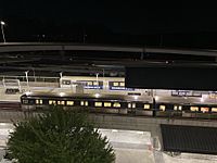
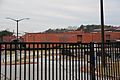
North Springs MARTA Station overlooking GA 400
-
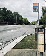
MARTA Bus Stop on Roswell Road


Police and Fire Departments
The Sandy Springs Police Department started in 2006. It has 149 full-time police officers. In 2020, they responded to over 124,000 calls for help. The city's fire department also began in 2006. It has 113 full-time firefighters. They handled over 17,000 responses to calls for service.
Images for kids
-

The contemporary skyline of Sandy Springs is dominated by the Concourse office towers, as seen in 2013.
-
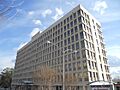
Northside Tower, a downtown landmark located in City Springs at Sandy Springs Place and Roswell Road
-
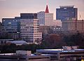
The skyline of Pill Hill in the Sandy Springs portion of Perimeter Center
-

Bull Sluice Lake, located in Morgan Falls Overlook Park
-
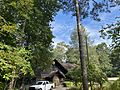
Hewlett Lodge, Headquarters for Chattahoochee National Recreation Area
-
North Springs Charter School of Arts and Sciences
-
Riverwood International Charter School
See also
 In Spanish: Sandy Springs (Georgia) para niños
