
Brookhaven, Georgia facts for kids
Brookhaven, once known as North Atlanta, is a city in the northeastern suburbs of Atlanta, located in DeKalb County, Georgia. It became DeKalb County's 11th city on July 31, 2012, after a public vote. The city officially started its operations on December 17, 2012. Brookhaven covers about 12 square miles and, with a population of 56,795 as of 2020, it is the second-largest city fully within DeKalb County.
Quick facts for kids
Brookhaven, Georgia
|
|||||
|---|---|---|---|---|---|

Brookhaven Village, located on Dresden Drive east of Peachtree Road
|
|||||
|
|||||
| Country | United States | ||||
| State | Georgia | ||||
| County | DeKalb | ||||
| Area | |||||
| • Total | 11.86 sq mi (30.71 km2) | ||||
| • Land | 11.73 sq mi (30.39 km2) | ||||
| • Water | 0.12 sq mi (0.31 km2) | ||||
| Population
(2020)
|
|||||
| • Total | 56,795 | ||||
| • Estimate
(2023)
|
57,945 | ||||
| • Density | 4,700.55/sq mi (1,814.85/km2) | ||||
| Time zone | UTC-5 (Eastern (EST)) | ||||
| • Summer (DST) | UTC-4 (EDT) | ||||
| ZIP codes |
30319, 30341
|
||||
| Area code(s) | 404/470/678/770 | ||||
| FIPS code | 13-10944 | ||||
| GNIS feature ID | 331243 | ||||


Contents
History of Brookhaven

The land where Brookhaven is now located was originally home to the Creek people.
Around 1810, John Evins became the first permanent European settler, starting a large farm called a plantation. In the 1830s, Harris and Solomon Goodwin took over the land. The old Goodwin family home and graveyard are still preserved today near Peachtree Road. A train station called Goodwin's was built here in 1873.
Another settlement, Cross Keys, was located about 1 mile north of Goodwin's. In 1876, it had about 250 people. It had two churches, a school, and cotton gins.
Around 1900, people from Atlanta started building summer homes in the area. In 1910, a large piece of land was bought to create a planned community around a golf course. This golf course opened in 1912. The area grew in phases, and by the end of World War II, most of the historic neighborhood was built. The golf club became part of the Capital City Club in 1911 and was renamed the Capital City Country Club.
In 1924, the area officially became a city called North Atlanta. However, in 1963, leaders asked for a vote to create a new city charter. Voters instead chose to dissolve the city, and North Atlanta stopped being a city in 1965.
From the 1950s to the 1970s, Brookhaven saw a lot of new homes and businesses being built. The Brookhaven/Oglethorpe MARTA Station (a train station) opened in 1984. In 1986, the Capital City Club and the homes around it were added to the National Register of Historic Places, and this area is now known as "Historic Brookhaven."
The idea of making Brookhaven a city again came up in 2007. People wanted more local control over things like planning, zoning, police, fire, and parks. This idea didn't gain enough support at first. But in 2011, the idea was brought up again. On July 31, 2012, 55% of voters chose to make Brookhaven a city. In December of that year, J. Max Davis was elected as the city's first mayor.
Geography of Brookhaven

Brookhaven is located at 33°52′47″N 84°21′6″W / 33.87972°N 84.35167°W. The city's borders are:
- The Fulton County line to the west.
- Unincorporated DeKalb County to the south.
- Clairmont Road and the city of Chamblee to the east.
- The city of Dunwoody at I-285 to the north.
You can see the official City of Brookhaven map online.
Neighborhoods and Districts


- Historic Brookhaven: This is the original neighborhood that gave the city its name. It has many beautiful old homes around the Capital City Country Club.
- Brookhaven Village: This is the city's downtown area, located on Dresden Drive near the Brookhaven MARTA station. It has shops, restaurants, homes, and offices.
- Lynwood Park: This neighborhood has a large park with basketball courts, tennis courts, a swimming pool, and a recreation center. Many new homes have been built here recently.
- Peachtree Road: This main road connects Brookhaven to Buckhead and Chamblee. Many businesses are along Peachtree Road, including Town Brookhaven, a large area with shops, restaurants, and apartments.
- North Brookhaven: This area is mostly suburban with many homes. It has two large parks, Blackburn Park and Murphey Candler Park, and the Nancy Creek PATH trail. It also has top public and private schools.
- Buford Highway: This area in southern Brookhaven is known for its diverse population and many international restaurants and businesses, especially Hispanic, Chinese, Vietnamese, and Korean.
- Lenox Park: This neighborhood has both homes and office buildings.
- LaVista Park: This neighborhood joined the City of Brookhaven in 2019.
People of Brookhaven (Demographics)
| Historical population | |||
|---|---|---|---|
| Census | Pop. | %± | |
| 1940 | 1,365 | — | |
| 1950 | 5,930 | 334.4% | |
| 1960 | 12,661 | 113.5% | |
| 1980 | 30,521 | — | |
| 1990 | 27,812 | −8.9% | |
| 2000 | 38,579 | 38.7% | |
| 2010 | 40,456 | 4.9% | |
| 2020 | 55,161 | 36.3% | |
| U.S. Decennial Census 1850-1870 1870-1880 1890-1910 1920-1930 1940 1950 1960 1970 1980 1990 2000 2010 2020 |
|||
Brookhaven first appeared in the U.S. census in 1940 as the town of North Atlanta. It was not listed in 1970 but reappeared in 1980. After becoming a city in 2012, it was listed as Brookhaven city in the 2020 census.
In 2020, Brookhaven had 55,161 people. There were 22,549 households and 11,443 families living in the city. The population density was about 4,634 people per square mile.
The median age in Brookhaven was about 34.6 years old. About 22.2% of the population was under 18, and 10.2% was 65 or older.
Race and Ethnicity
| Race / Ethnicity (NH = Non-Hispanic) | Pop 2000 | Pop 2010 | Pop 2020 | % 2000 | % 2010 | % 2020 |
|---|---|---|---|---|---|---|
| White alone (NH) | 18,770 | 19,287 | 30,423 | 48.65% | 47.67% | 55.15% |
| Black or African American alone (NH) | 6,615 | 4,137 | 6,207 | 17.15% | 10.23% | 11.25% |
| Native American or Alaska Native alone (NH) | 58 | 74 | 49 | 0.15% | 0.18% | 0.09% |
| Asian alone (NH) | 1,864 | 1,898 | 3,979 | 4.83% | 4.69% | 7.21% |
| Pacific Islander alone (NH) | 14 | 19 | 14 | 0.04% | 0.05% | 0.03% |
| Other race alone (NH) | 66 | 99 | 316 | 0.17% | 0.24% | 0.57% |
| Mixed Race or Multi-Racial (NH) | 618 | 516 | 1,963 | 1.60% | 1.28% | 3.56% |
| Hispanic or Latino (any race) | 10,574 | 14,426 | 12,210 | 27.41% | 35.66% | 22.14% |
| Total | 38,579 | 40,456 | 55,161 | 100.00% | 100.00% | 100.00% |
According to a 2022 survey, Brookhaven's population is made up of people from many different backgrounds. The largest groups are White, Black or African American, and Asian. Many people also identify as Hispanic or Latino, who can be of any race.
Economy
Brookhaven has several large shopping and business areas. These include Town Brookhaven, which opened in 2010, and Northeast Plaza, a shopping center on Buford Highway known for its discount and Hispanic-focused stores.
In 2017, The Weather Company, which owns The Weather Channel, moved its offices to Brookhaven.
Brookhaven continues to grow with new projects. In 2019, the city approved plans for an 8-story Ronald McDonald House. This facility will provide temporary housing for families whose children are receiving medical treatment nearby. Emory University also announced plans to build a large medical complex, including a hospital and apartments, in Brookhaven.
The city is also improving its parks. The Atlanta Hawks basketball team helped fund upgrades to the basketball court at Lynwood Park. The Hawks' own $50 million training facility is also located in Brookhaven.
Education

Brookhaven is home to colleges and universities like Oglethorpe University. Georgia State University also has a satellite campus here for its business programs. Both are on Peachtree Road.
Schools for Kids
The DeKalb County School System manages the public schools in Brookhaven. Some elementary schools within the city are Ashford Park, Montclair, Montgomery, and Woodward. Montgomery Elementary is known for its high test scores.
Kittredge Magnet School is a special school for high-achieving students in grades 4-6. Students can apply or be chosen by a lottery system to attend.
Middle schools serving the city include Chamblee Middle School and Sequoyah Middle School. High schools are Cross Keys High School in Brookhaven and Chamblee Charter High School.
There are also private schools like Our Lady of the Assumption Catholic School, St. Martin in the Fields Episcopal School, and Marist School. PATH Academy, a charter school, is also in Brookhaven.
Public Libraries
The DeKalb County Public Library operates the Brookhaven Library, where you can find books and other resources.
Parks

Brookhaven has many parks for outdoor activities:
- Ashford Forest Preserve: A 33-acre green space with a 1-mile trail.
- Ashford Park: A 3-acre park with tennis courts, an activity building, and playgrounds.
- Blackburn Park: A 49.5-acre park with tennis courts, softball fields, picnic areas, and trails.
- Briarwood Park: An 18-acre park with a swimming pool, tennis courts, a recreation center, and trails.
- Brookhaven Park: A 9-acre park with open lawns and trails.
- Lynwood Park: A 17-acre park with a recreation center, swimming pool, basketball and tennis courts, and a playground.
- Murphey Candler Park: A large 135-acre park with youth sports leagues, a 2-mile nature trail, picnic areas, a pool, and a lake.
- Skyland Park: An 11-acre park with open lawns, a pavilion, and a dog park.
- Peachtree Creek Greenway: A multi-use trail and green space.
Transportation
Roads
- Ashford-Dunwoody Road: A north-south road that connects to Interstate 285.
- Peachtree Road: The main north-south road, part of Georgia State Route 141, connecting to Atlanta and Chamblee.
- North Druid Hills Road: A north-south road providing access from Interstate 85.
- Buford Highway: A north-south road known for its many multicultural shops and restaurants.
Interstates
- I-285: A major interstate that circles the Atlanta area and is near Brookhaven's northern border.
- I-85: A major interstate that passes through the southeastern part of Brookhaven.
Public Transportation (Mass Transit)
The Metropolitan Atlanta Rapid Transit Authority (MARTA) provides train and bus services in Brookhaven and the surrounding areas.
Trains
- The Brookhaven/Oglethorpe MARTA station is in the center of Brookhaven and is served by the Gold Line.
- The northern part of Brookhaven is close to the Medical Center and Dunwoody Station, both on the Red Line.

Buses
Several bus routes serve Brookhaven from the Brookhaven/Oglethorpe and Medical Center Stations, including:
- Route 8 - North Druid Hills Rd.
- Route 25 - Peachtree Blvd.
- Route 39 - Buford Highway
- Route 47 - I-85 Access Rd./Briarwood Rd.
- Route 110 - Peachtree Rd.
- Route 825 - Johnson Ferry Rd.
Walking and Biking
Brookhaven is working to make it easier and safer for people to walk and bike. In 2016, the city created a plan for bike lanes and trails. In 2017, a new rule was passed requiring sidewalks on all new and improved local residential streets. Bike lanes are also required where recommended.
In 2020, Brookhaven approved the Vulnerable Road User Ordinance. This rule gives extra protection to people who are not in cars, like walkers, bike riders, and scooter riders. Drivers must keep a safe distance (at least three feet) from them. This shows Brookhaven's commitment to making its roads safe for everyone.
Peachtree Creek Greenway
The Peachtree Creek Greenway is a multi-use trail being built in Brookhaven. The first part of the trail, 1.25 miles long, opened in late 2019. When finished, the Greenway will connect Brookhaven to other areas like Atlanta and Doraville. It will be 12.3 miles long in total. The goal is to provide easy access to trails for transportation and fun, improving the quality of life for residents.
Images for kids
-
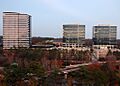
Skyscrapers in the Brookhaven portion of Perimeter Center.

See also
 In Spanish: Brookhaven (Georgia) para niños
