
Gwinnett County, Georgia facts for kids
Quick facts for kids
Gwinnett County
|
|||||
|---|---|---|---|---|---|

Gwinnett Justice and Administration Center
|
|||||
|
|||||

Location within the U.S. state of Georgia
|
|||||
 Georgia's location within the U.S. |
|||||
| Country | |||||
| State | |||||
| Founded | December 15, 1818 | ||||
| Named for | Button Gwinnett | ||||
| Seat | Lawrenceville | ||||
| Largest city | Peachtree Corners | ||||
| Area | |||||
| • Total | 437 sq mi (1,130 km2) | ||||
| • Land | 430 sq mi (1,100 km2) | ||||
| • Water | 6.4 sq mi (17 km2) 1.5%% | ||||
| Population
(2020)
|
|||||
| • Total | 942,627 | ||||
| • Estimate
(2023)
|
983,526 |
||||
| • Density | 2,123/sq mi (820/km2) | ||||
| Time zone | UTC−5 (Eastern) | ||||
| • Summer (DST) | UTC−4 (EDT) | ||||
| Congressional districts | 6th, 7th, 9th | ||||


Gwinnett County is a large county in the north central part of Georgia. It's a key part of the Atlanta metropolitan area, located just northeast of Atlanta. In 2020, Gwinnett County was home to over 957,000 people. This makes it the second-most populated county in Georgia.
The main city and government center of Gwinnett County is Lawrenceville. The county is named after Button Gwinnett, who was one of the people who signed the Declaration of Independence. Gwinnett County is known for being very diverse, with many different cultures and backgrounds.
Contents
- History of Gwinnett County
- Geography and Nature
- Communities in Gwinnett County
- Population and Diversity
- Economy and Businesses
- Hospitals
- Media and News
- Parks and Recreation
- Education in Gwinnett County
- Sports Teams
- Transportation and Travel
- Notable People from Gwinnett County
- Images for kids
- See also
History of Gwinnett County
Early Days and Founding
In 1813, a place called Fort Daniel was built in the area that would later become Gwinnett County. The county itself was officially created in 1818. It was formed from parts of Jackson County and land that used to belong to the Creek Indian people.
The first county election was held at the home of Elisha Winn. The first court meeting happened in his barn! Later, Lawrenceville became the county's official seat.
Important Court Case
In 1831, an important court case happened in Lawrenceville. It was called Worcester v. Georgia. This case was about whether Georgia had the right to make laws for Native American lands. The US Supreme Court decided that only the federal government could make rules for these lands. This decision is still important today.
Civil War and After
During the American Civil War, Gwinnett County's leaders voted against Georgia leaving the United States. Towards the end of the war, Union soldiers came through the county as part of the Atlanta Campaign.
After the war, during a time called Reconstruction, the Freedmen's Bureau helped people in Gwinnett County. In 1871, the courthouse in Lawrenceville was burned down.
Early Industries
In the early days, people in Gwinnett County did some gold mining. A cotton factory, the Gwinnett Manufacturing Company, operated in Lawrenceville from the 1850s until it burned down in 1865. The Bona Allen Company in Buford, Georgia made leather goods like saddles for many years, from 1873 to 1981.
In 1914, a part of Gwinnett County was used to create a new county called Barrow County.
Geography and Nature
Gwinnett County covers about 437 square miles. Most of this is land, with a small amount of water. The county is located in the Piedmont region of Georgia, which means it has rolling hills.
The county is also located along the Eastern Continental Divide. This is an imaginary line where water flows either towards the Atlantic Ocean or towards the Gulf of Mexico. A part of the county to the northwest is included in the Chattahoochee River National Recreation Area.
Lake Lanier, a large lake at the northern edge of the county, is a source of water for the region. Sometimes, there are discussions about how to share this water with other states.
Neighboring Counties
Gwinnett County shares borders with several other counties:
- Forsyth County – to the north
- Hall County – to the northeast
- Jackson County – to the northeast
- Barrow County – to the east
- Walton County – to the southeast
- Rockdale County – to the south
- DeKalb County – to the southwest
- Fulton County – to the west
Communities in Gwinnett County
Cities
- Auburn (partly in Barrow County)
- Berkeley Lake
- Buford (partly in Hall County)
- Dacula
- Duluth
- Grayson
- Lawrenceville
- Lilburn
- Loganville (partly in Walton County)
- Mulberry (proposed)
- Norcross
- Peachtree Corners
- Snellville
- Sugar Hill
- Suwanee
Towns
- Braselton (partly in Jackson County, Hall County, and Barrow County)
- Rest Haven (partly in Hall County)
Census-Designated Places
- Mountain Park
Unincorporated Communities
These are areas that are not part of an official city or town:
- Allendale
- Centerville
- Five Forks
- Harbins
- Hog Mountain
- Lucky Shoals
- Mechanicsville
- Mountain Park
- Rockbridge
- Rosebud
Population and Diversity
Gwinnett County has grown very quickly and become much more diverse over the years. In 1990, most of the people living here were white. But by 2007, it became a "majority-minority" county. This means that groups other than non-Hispanic white people made up more than half of the population.
As of the 2020 Census, Gwinnett County had 957,062 people. It is known for its large populations of Black, Hispanic, and Asian residents. No single ethnic group makes up more than a third of the county's population. This makes Gwinnett County the most ethnically diverse county in Georgia.
Economy and Businesses
Many different companies have their headquarters or important offices in Gwinnett County. This shows that the county is a busy place for business. Some of these companies include:
- AGCO in Duluth
- American Megatrends near Norcross
- ASHRAE in Peachtree Corners
- Comcast Corporation (Xfinity, NBCUniversal) has its Southeast Headquarters in Peachtree Corners
- Canon has its southeast region headquarters in Norcross
- Datapath, Inc. (secure communications) near Duluth
- CarMax, Mass Mutual, Honeywell, Sprint Corporation, Siemens Industry Automation, Fleetcor, ACI Worldwide, and CMD Group in Peachtree Corners
- Hapag-Lloyd’s North American Headquarters in Peachtree Corners
- The Harlem Globetrotters are headquartered in Peachtree Corners
- Primerica near Duluth
- Scientific Atlanta in Lawrenceville
- United States Tennis Association (USTA)’s Southern Section headquarters in Peachtree Corners
- Waffle House near Norcross
- Yerkes National Primate Research Center (a research center for primates) near Lawrenceville
Hospitals
Gwinnett County has several hospitals that provide healthcare to its residents:
- Northside Hospital Gwinnett – in Lawrenceville
- Northside Hospital Duluth – in Duluth
- Piedmont Hospital Eastside – in Snellville
Media and News
The main newspaper for Gwinnett County is the Gwinnett Daily Post. There is also a Spanish language newspaper called El Nuevo Georgia, which has its main office near Norcross. Telemundo Atlanta and The Atlanta Journal-Constitution also have operations in Gwinnett.
Parks and Recreation
The Gwinnett County Parks and Recreation department manages many parks, playgrounds, swimming pools, golf courses, and recreation centers. They also offer fun and educational programs. The parks system has won many awards, including a gold medal in 2008 for being one of the best park systems in the country. They are also known for using STEM in their programs.
Education in Gwinnett County
Public Schools
Most public schools in Gwinnett County are run by Gwinnett County Public Schools. The only exception is the city of Buford, which has its own school district. Gwinnett County Public Schools is the largest school district in Georgia. It has 143 schools, including 21 high schools, 29 middle schools, 80 elementary schools, and 13 special schools.
There is also a charter school in Peachtree Corners called International Charter Academy of Georgia.
Private Schools
Gwinnett County also has several private schools:
- Greater Atlanta Christian School in Norcross
- Hebron Christian Academy in Dacula
- Providence Christian Academy in Lilburn
- Wesleyan School in Peachtree Corners
Colleges and Universities
For higher education, Gwinnett County has several colleges and universities:
- Georgia Gwinnett College in Lawrenceville
- Gwinnett Technical College also in Lawrenceville
- Philadelphia College of Osteopathic Medicine in Suwanee
- Trevecca Nazarene University has an adult education site in Duluth
- University of Georgia has a branch campus in Lawrenceville
Sports Teams
Gwinnett County is home to several sports teams that play in professional leagues.
| Club | Sport | League | Venue | Founded | Titles |
|---|---|---|---|---|---|
| Atlanta Gladiators | Ice hockey | ECHL | Gas South Arena | 1995 | 0 |
| Gwinnett Stripers | Baseball | International League | Coolray Field | 2009 | 0 |
| Georgia Swarm | Lacrosse | National Lacrosse League | Gas South Arena | 2004 | 1 |
The Georgia Swarm lacrosse team moved to Gwinnett in 2016 and won the league championship in 2017! Gwinnett also has the Gwinnett Lions Rugby Football Club.
Transportation and Travel
Airport
Gwinnett County has its own regional airport, called Gwinnett County Airport. For bigger flights, the closest major airport is Hartsfield–Jackson Atlanta International Airport.
Major Roads and Highways
Many important roads and highways run through Gwinnett County, connecting it to other parts of Georgia and beyond.
 Interstate 85
 Interstate 985
 U.S. Route 23
 U.S. Route 29
 U.S. Route 78
 State Route 8
 State Route 10
 State Route 13
 State Route 20
 State Route 84
 State Route 120
 State Route 124
 State Route 140
 State Route 141
 State Route 264
 State Route 316
 State Route 317
 State Route 324
 State Route 347
 State Route 365
 State Route 378
 State Route 403 (unsigned designation for I-85)
 State Route 419 (unsigned designation for I-985)
Public Transport and Trails
Gwinnett County has bus services like GRTA Xpress and Ride Gwinnett. There are also plans to connect the county to Atlanta's train system.
For walking and biking, Gwinnett County is working on building many multi-use trails. These trails are great for exercise and getting around.
- Beaver Ruin Creek Greenway (Proposed)
- Camp Creek Greenway
- Cedar Creek Trail Loop
- Crooked Creek Trail (Proposed)
- Harbins Greenway (Proposed)
- Ivy Creek Greenway (Under construction)
- Ivy Creek-Snellville Trail (Proposed)
- Norcross-Lilburn Trail (Proposed)
- Piedmont Pathway (Proposed)
- Riverlands Path (Under construction)
- Sugar Hill Greenway (Under construction)
- Suwanee Creek Greenway (Under construction)
- The Loop Trail (Proposed)
- Western Gwinnett Bikeway (Under construction)
In 2016, Suwanee started the first Bike Share program in Gwinnett County, making it easier for people to rent bikes.
Notable People from Gwinnett County
Many well-known people have connections to Gwinnett County, including athletes and actors:
- David Andrews, NFL football player
- Alvin Kamara, NFL running back
- Maya Moore, Women's Basketball Player
- Elijah Bryant, basketball player
- Sam Flint, actor
- Chandler Massey, actor (won Emmy Awards for Days of Our Lives)
- James Ramsey, Major League Baseball player
- Trey Thompkins, basketball player
- Brice Butler, NFL wide receiver
- Jodie Meeks, NBA shooting guard
- Rittz, musician
- Migos, hip hop group
Images for kids
-
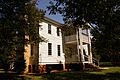
The Elisha Winn House served as Gwinnett County's first courthouse.
-
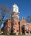
The Historic Gwinnett County Courthouse (no longer used).


See also
 In Spanish: Condado de Gwinnett para niños
