Jackson County, Georgia facts for kids
Quick facts for kids
Jackson County
|
||
|---|---|---|

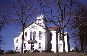
Jackson County courthouse in Jefferson
|
||
|
||

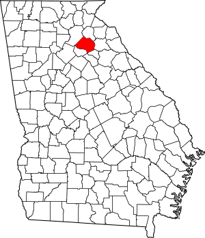
Location within the U.S. state of Georgia
|
||
 Georgia's location within the U.S. |
||
| Country | ||
| State | ||
| Founded | 1796 | |
| Named for | James Jackson | |
| Seat | Jefferson | |
| Largest city | Jefferson | |
| Area | ||
| • Total | 343 sq mi (890 km2) | |
| • Land | 340 sq mi (900 km2) | |
| • Water | 3.4 sq mi (9 km2) 1.0%% | |
| Population
(2020)
|
||
| • Total | 75,907 | |
| • Estimate
(2023)
|
88,615 |
|
| • Density | 221.3/sq mi (85.45/km2) | |
| Time zone | UTC−5 (Eastern) | |
| • Summer (DST) | UTC−4 (EDT) | |
| Congressional district | 9th | |
Jackson County is a county located in the northeastern part of the U.S. state of Georgia. It's like a smaller region within the state. In 2020, about 75,907 people lived here. The main town, or county seat, is Jefferson. Jackson County is part of a larger area that includes Atlanta and Athens, making it a connected and busy place.
Contents
History of Jackson County
Most of the first non-Native American settlers arrived in 1786. On February 11, 1796, Jackson County was created from a part of Franklin County. The county was named after James Jackson. He was a hero from the American Revolutionary War. He also served as a leader in the government, including as a Congressman, Senator, and Governor of Georgia.
When it was first formed, Jackson County was very large. Its first county seat, or main town, was Clarksboro.
In 1801, the Georgia government gave a lot of land in Jackson County for a new state college. This college, now called the University of Georgia, started classes that same year. The city of Athens grew up around the school. Also in 1801, a new county called Clarke County was created around Athens. This meant Jackson County became smaller. The county seat then moved to an old Native American village called Thomocoggan. This spot had plenty of water from Curry Creek and four big springs. In 1804, the town was renamed Jefferson, in honor of Thomas Jefferson.
Over the years, Jackson County lost more land as new counties were formed. This happened when Madison County was created in 1811. Later, in 1818, Walton, Gwinnett, and Hall counties were formed. Then, in 1858, Banks County was created. Finally, in 1914, Barrow County was formed. Each time, Jackson County became a bit smaller.
The first building for the county government, called a courthouse, was made of logs and wood. It had a jail attached. A second, larger brick courthouse was built in 1817. In 1880, a third courthouse was built. This building was used continuously for a very long time, until 2004. That's when the current courthouse was built in Jefferson.
Geography of Jackson County
Jackson County covers about 343 square miles. Most of this area, about 340 square miles, is land. The rest, about 3.4 square miles, is water.
Most of Jackson County is in the Upper Oconee River area. This river flows into the larger Altamaha River. A small part of the county's northern edge is in the Broad River area. This river flows into the Savannah River.
Rivers and Creeks
- North Oconee River
- Sandy Creek (Georgia)
- Curry Creek
- Middle Oconee River
- Pond Fork
- Allen Creek (Holders Creek)
- Mulberry River
Neighboring Counties
- Banks County - to the north
- Madison County - to the east
- Clarke County - to the southeast
- Barrow County - to the west
- Hall County - to the northwest
Communities in Jackson County
Jackson County has several towns and cities where people live.
Cities
Towns
Unincorporated Communities
These are smaller areas that are not officially cities or towns.
- Apple Valley
- Attica
- Brockton
- Center
- Clarksboro
Population and People
| Historical population | |||
|---|---|---|---|
| Census | Pop. | %± | |
| 1800 | 7,736 | — | |
| 1810 | 10,569 | 36.6% | |
| 1820 | 8,355 | −20.9% | |
| 1830 | 9,004 | 7.8% | |
| 1840 | 8,522 | −5.4% | |
| 1850 | 9,768 | 14.6% | |
| 1860 | 10,605 | 8.6% | |
| 1870 | 11,181 | 5.4% | |
| 1880 | 16,297 | 45.8% | |
| 1890 | 19,176 | 17.7% | |
| 1900 | 24,039 | 25.4% | |
| 1910 | 30,169 | 25.5% | |
| 1920 | 24,654 | −18.3% | |
| 1930 | 21,609 | −12.4% | |
| 1940 | 20,089 | −7.0% | |
| 1950 | 18,997 | −5.4% | |
| 1960 | 18,499 | −2.6% | |
| 1970 | 21,093 | 14.0% | |
| 1980 | 25,343 | 20.1% | |
| 1990 | 30,005 | 18.4% | |
| 2000 | 41,589 | 38.6% | |
| 2010 | 60,485 | 45.4% | |
| 2020 | 75,907 | 25.5% | |
| 2023 (est.) | 88,615 | 46.5% | |
| U.S. Decennial Census 1790-1880 1890-1910 1920-1930 1930-1940 1940-1950 1960-1980 1980-2000 2010 |
|||
The population of Jackson County has changed a lot over the years. The table above shows how many people lived here during different census years. A census is a count of the population that happens every ten years.
As of the 2020 census, there were 75,907 people living in Jackson County. These people made up 25,180 households. About 19,467 of these households were families.
| Race | Num. | Perc. |
|---|---|---|
| White (non-Hispanic) | 59,064 | 77.81% |
| Black or African American (non-Hispanic) | 5,136 | 6.77% |
| Native American | 127 | 0.17% |
| Asian | 1,744 | 2.3% |
| Pacific Islander | 30 | 0.04% |
| Other/Mixed | 3,094 | 4.08% |
| Hispanic or Latino | 6,712 | 8.84% |
This table shows the different groups of people living in Jackson County in 2020. It helps us understand the diversity of the county.
Education in Jackson County
Most of the schools in Jackson County are part of the Jackson County School District. However, some parts of the county, like Commerce and Jefferson, have their own school districts. These are the Commerce City School District and the Jefferson City School District.
Fun Places to Visit
Jackson County has many interesting places to visit and fun things to do!
Attractions
- Chateau Elan (Braselton) - A beautiful winery and resort.
- La Vaquita Flea Market (Pendergrass) - A place to find unique items.
- Mayfield Dairy Visitors Center (Braselton) - Learn how ice cream is made!
- Sandy Creek Golf Course (Commerce) - A great spot for golf.
- Tanger Outlet Center (Commerce) - A popular place for shopping.
National Historic Places
These are places that are important to the history of the United States.
- Braselton Historic District
- Commerce Commercial Historic District
- Governor L. G. Hardman House (Commerce)
- Hillcrest-Allen Clinic and Hospital (Hoschton)
- Holder Plantation (Jefferson)
- Hoschton Depot
- Old Jackson County Courthouse (Jefferson)
- Jefferson Historic District
- Oak Avenue Historic District(Jefferson)
- Paradise Cemetery (Jefferson)
- Seaborn M. Shankle House (Commerce)
- Shields-Etheridge Farm
- Talmo Historic District
- Williamson-Maley-Turner Farm (Jefferson)
Parks and Cultural Institutions
- Crawford W. Long Museum (Jefferson) - Learn about a famous doctor.
- Hurricane Shoals Park - A beautiful park with natural rock formations.
Events
There are many events throughout the year in Jackson County.
- Daisy Festival - Happens in May in Nicholson.
- Mule Days - Happens in May at Shields-Etheridge Farm.
- Annual City Lights Festival - Happens in mid-June in Commerce.
- Celebrate Braselton - A July 4th celebration in Braselton.
- Art in the Park - Happens in mid-September at Hurricane Shoals.
- Annual Fall Festival - Happens in September in Hoschton.
- School Band Concerts - High schools and middle schools in Jackson County have concerts all year.
Transportation in Jackson County
Jackson County has many roads and paths that help people get around.
Major Highways
These are big roads that connect Jackson County to other places.
 Interstate 85
 U.S. Route 129
 U.S. Route 129 Business
 U.S. Route 441
 U.S. Route 441 Business
 State Route 11
 State Route 11 Business
 State Route 11 Connector
 State Route 15
 State Route 15 Alternate
 State Route 53
 State Route 59
 State Route 60
 State Route 82
 State Route 82 Connector
 State Route 98
 State Route 124
 State Route 330
 State Route 332
 State Route 334
 State Route 335
 State Route 346 (used to be a highway)
 State Route 403 (this is another name for I-85)
Walking and Biking Paths
Jackson County also has many trails for walking and cycling.
- Fox Smallwood Dr Trail
- American Veterans Memorial Park Trail
- Commerce Middle School Track
- Curry Creek Reservoir Trail
- Jefferson Memorial Stadium Track
- East Jackson Park Walking Trail
- South Jackson Elementary Nature Trail & Walking Track
- Hurricane Shoals Nature Trail
- Sells Mill Nature Trail
- Sandy Creek Park Walking Trail
- Braselton Riverwalk Trail
- East Jackson High School Track
- W Jackson Middle School Track
- West Jackson Park Walking Track
- Jackson County High School Track & Nature Trail
See also
 In Spanish: Condado de Jackson (Georgia) para niños
 | DeHart Hubbard |
 | Wilma Rudolph |
 | Jesse Owens |
 | Jackie Joyner-Kersee |
 | Major Taylor |


