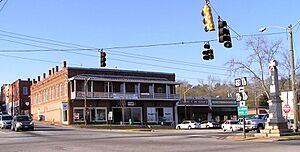
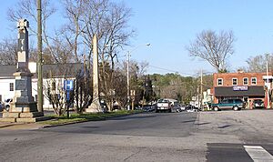
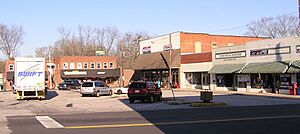
Jefferson, Georgia facts for kids
Quick facts for kids
Jefferson, Georgia
|
||
|---|---|---|
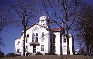
Jackson County Courthouse in Jefferson
|
||
|
||
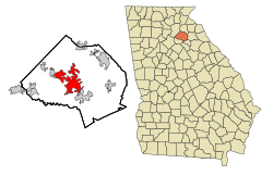
Location in Jackson County and the state of Georgia
|
||
| Country | United States | |
| State | Georgia | |
| County | Jackson | |
| Named for | Thomas Jefferson | |
| Government | ||
| • Type | Local government | |
| Area | ||
| • Total | 22.87 sq mi (59.23 km2) | |
| • Land | 22.53 sq mi (58.36 km2) | |
| • Water | 0.34 sq mi (0.88 km2) | |
| Elevation | 751 ft (229 m) | |
| Population
(2020)
|
||
| • Total | 13,233 | |
| • Density | 587.32/sq mi (226.77/km2) | |
| Time zone | UTC-5 (Eastern (EST)) | |
| • Summer (DST) | UTC-4 (EDT) | |
| ZIP code |
30549
|
|
| Area code(s) | 706 | |
| FIPS code | 13-41988 | |
| GNIS feature ID | 0356332 | |
Jefferson is a city located in Jackson County, Georgia, in the United States. It's also the main town, known as the county seat, where the county government offices are. In 2020, about 13,233 people lived there, and by 2024, the population was estimated to be around 17,215. This shows that Jefferson is a growing city!
Contents
A Look Back in Time
Jefferson was started in the year 1800. In the same year, it became the main town, or "county seat," for Jackson County. Before that, the county seat was in a place called Clarkesboro. Jefferson officially became a town in 1806. Later, in 1896, it was recognized as a city. The city was named after Thomas Jefferson, who was a very important person in American history.
Where is Jefferson Located?
Jefferson is in the middle of Jackson County. You can find it at these coordinates: 34°7′36″N 83°35′25″W / 34.12667°N 83.59028°W. It shares borders with Pendergrass to the northwest and Arcade to the southeast.
Getting Around Jefferson
A major road, U.S. Route 129, goes through the southwest part of the city. If you head northwest on this road, you'll reach Gainesville in about 21 miles. If you go southeast, you'll get to Athens in about 19 miles.
Interstate 85 also passes through the northern edge of Jefferson. It's about 5 miles northwest of the city center. You can get on or off I-85 at Exits 137 and 140. This interstate highway can take you southwest about 55 miles to Atlanta. Or, if you go northeast, you'll reach Greenville, South Carolina, which is about 90 miles away.
Land and Water
The United States Census Bureau says that Jefferson covers a total area of about 22.87 square miles (59.23 square kilometers). Most of this area, about 22.53 square miles (58.36 square kilometers), is land. The rest, about 0.34 square miles (0.88 square kilometers), is water.
Curry Creek, a small river that flows into the North Oconee River, is just east of downtown Jefferson. The Middle Oconee River runs along the western side of the city.
Who Lives in Jefferson?
The number of people living in Jefferson has changed a lot over the years. Here's how the population has grown:
| Historical population | |||
|---|---|---|---|
| Census | Pop. | %± | |
| 1880 | 419 | — | |
| 1890 | 540 | 28.9% | |
| 1900 | 726 | 34.4% | |
| 1910 | 1,207 | 66.3% | |
| 1920 | 1,626 | 34.7% | |
| 1930 | 1,869 | 14.9% | |
| 1940 | 1,839 | −1.6% | |
| 1950 | 2,040 | 10.9% | |
| 1960 | 1,746 | −14.4% | |
| 1970 | 1,647 | −5.7% | |
| 1980 | 1,820 | 10.5% | |
| 1990 | 2,763 | 51.8% | |
| 2000 | 3,825 | 38.4% | |
| 2010 | 9,432 | 146.6% | |
| 2020 | 13,233 | 40.3% | |
| U.S. Decennial Census | |||
Population in 2020
In 2020, the 2020 United States census counted 13,233 people living in Jefferson. There were 3,933 households, which are groups of people living together, and 2,885 families.
Growing Community
A report from 2024 by the U.S. Census Bureau said that Jefferson, Georgia, was the fastest-growing "micropolitan statistical area" in the country between 2020 and 2023. A micropolitan area is a city with a population between 10,000 and 50,000, plus the nearby areas that are connected to it. This means Jefferson's population grew by an estimated 16.24% during that time!
Diverse Community
Here's a look at the different groups of people who lived in Jefferson in 2020:
| Race | Num. | Perc. |
|---|---|---|
| White (non-Hispanic) | 10,240 | 77.38% |
| Black or African American (non-Hispanic) | 1,087 | 8.21% |
| Native American | 22 | 0.17% |
| Asian | 269 | 2.03% |
| Pacific Islander | 3 | 0.02% |
| Other/mixed | 572 | 4.32% |
| Hispanic or Latino | 1,040 | 7.86% |
Education
Jefferson is served by two main school districts, helping students from preschool all the way through high school.
Jackson County School District
The Jackson County School District teaches students from preschool up to twelfth grade. As of March 2024, this district had 10,646 students. It includes:
- East Jackson Elementary School
- Gum Springs Elementary School
- Maysville Elementary School
- North Jackson Elementary School
- South Jackson Elementary School
- West Jackson Elementary School
- Heroes Elementary School
- East Jackson Middle School
- West Jackson Middle School
- Legacy Knoll Middle School
- East Jackson High School
- Jackson County High School
- EMPOWER College and Career Center (a special charter school)
Jefferson City School District
The Jefferson City School District also serves students from preschool to twelfth grade. In March 2024, this district had 4,218 students. Its schools are:
- Center for Early Learning (preschool)
- Jefferson Elementary School
- Jefferson Academy
- Jefferson Middle School
- Jefferson High School
Martin Institute
The Martin Institute was an important school in Jefferson for many years. It operated from 1818 until 1942.
Notable People
Many interesting people have come from Jefferson, Georgia. Here are a few of them:
- Chris Beck, a baseball pitcher for the New York Mets
- Hiram Parks Bell, who served as a U.S. Representative
- Damon Jesse Gause, a World War II war hero
- Brantley Gilbert, a popular country music singer and songwriter
- Crawford W. Long, a doctor famous for being the first to use ether to help people sleep during surgery
- Brandon Mosley, a former football player for Auburn University and the New York Giants
- Corey Smith, another country music singer and songwriter
- Malaki Starks, a safety for the Georgia Bulldogs football team
- Sammy Brown, a linebacker for the Clemson Tigers
See also
 In Spanish: Jefferson (Georgia) para niños
 | Emma Amos |
 | Edward Mitchell Bannister |
 | Larry D. Alexander |
 | Ernie Barnes |


