Maysville, Georgia facts for kids
Quick facts for kids
Maysville, Georgia
|
||
|---|---|---|
|
||

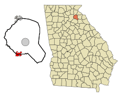
Location in Banks County and the state of Georgia
|
||
| Country | United States | |
| State | Georgia | |
| Counties | Banks, Jackson | |
| Area | ||
| • Total | 4.72 sq mi (12.22 km2) | |
| • Land | 4.66 sq mi (12.06 km2) | |
| • Water | 0.06 sq mi (0.16 km2) | |
| Elevation | 889 ft (271 m) | |
| Population
(2020)
|
||
| • Total | 1,867 | |
| • Density | 400.99/sq mi (154.83/km2) | |
| Time zone | UTC-5 (Eastern (EST)) | |
| • Summer (DST) | UTC-4 (EDT) | |
| ZIP code |
30558
|
|
| Area code(s) | 706 | |
| FIPS code | 13-50484 | |
| GNIS feature ID | 2406117 | |
Maysville is a small town located in the state of Georgia, in both Banks and Jackson counties. In 2020, about 1,867 people lived there.
Contents
Maysville's Past: A Brief History
Maysville became an official town in 1879. This happened when the Georgia General Assembly, which is like Georgia's state government, decided to make it a town.
Where is Maysville? Geography and Location
Maysville covers about 4.7 square miles (12.2 square kilometers). Most of this area is land, with a small part being water.
The town is located about 70 miles northeast of Atlanta. Other towns close to Maysville include Commerce, Gillsville, Lula, Jefferson, and Pendergrass.
Maysville's Weather: Climate Information
Maysville has a humid subtropical climate. This means it has hot, humid summers and mild winters.
- Summer: The hottest month is usually July, with average high temperatures around 90°F (32°C).
- Winter: January is the coldest month, with average low temperatures around 29°F (-1.6°C).
- Snow: Sometimes, Maysville gets a lot of snow. For example, in March 2009, several inches of snow fell across Banks County.
How Maysville is Governed: The City Council
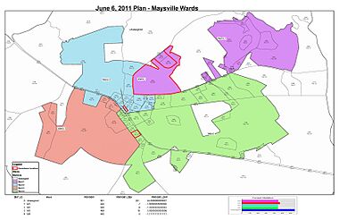
The Maysville City Council helps run the town along with the mayor. They make decisions about local issues. This council was officially created in March 2010.
Who Can Be on the City Council?
To be a member of the city council or the mayor, a person must:
- Have lived in Maysville for at least 12 months before the election.
- Continue to live in Maysville during their time in office.
- Be registered and able to vote in Maysville's elections.
Council members serve for four years.
City Council Meetings: How They Work
The city council has an important meeting on the first Monday of January after each election. During this meeting, new members take an oath of office.
The mayor can also ask for special meetings if needed. All council members must be told about these special meetings at least 48 hours beforehand.
Maysville's People: Demographics
| Historical population | |||
|---|---|---|---|
| Census | Pop. | %± | |
| 1880 | 116 | — | |
| 1890 | 327 | 181.9% | |
| 1900 | 453 | 38.5% | |
| 1910 | 805 | 77.7% | |
| 1920 | 795 | −1.2% | |
| 1930 | 619 | −22.1% | |
| 1940 | 514 | −17.0% | |
| 1950 | 533 | 3.7% | |
| 1960 | 553 | 3.8% | |
| 1970 | 553 | 0.0% | |
| 1980 | 619 | 11.9% | |
| 1990 | 728 | 17.6% | |
| 2000 | 1,247 | 71.3% | |
| 2010 | 1,798 | 44.2% | |
| 2020 | 1,867 | 3.8% | |
| U.S. Decennial Census | |||
Every ten years, the United States counts its population in a process called the census. This helps us understand how many people live in a place and what groups they belong to.
2020 Census Results
In 2020, Maysville had 1,867 people. The population was split between the two counties it's in:
- 926 people lived in Banks County.
- 872 people lived in Jackson County.
2010 Census Results
In 2010, Maysville had 1,798 people living in 669 households.
- Most residents (93.8%) were white.
- About 2.2% were African American.
- About 2.6% of the population identified as Hispanic or Latino.
The average age of people in Maysville was 38.4 years old.
Learning in Maysville: Education
Students in Maysville attend schools based on which county they live in:
- If they live in Banks County, they are part of the Banks County School District. They attend Banks County High School.
- If they live in Jackson County, they are part of the Jackson County School District.
See also
 In Spanish: Maysville (Georgia) para niños
 | Janet Taylor Pickett |
 | Synthia Saint James |
 | Howardena Pindell |
 | Faith Ringgold |


