Hoschton, Georgia facts for kids
Quick facts for kids
Hoschton, Georgia
|
|
|---|---|

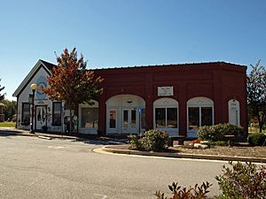
Hoschton City Hall
|
|
| Motto(s):
"Planning our future, honoring our past."
|
|

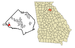
Location in Jackson County and the state of Georgia
|
|
| Country | United States |
| State | Georgia |
| County | Jackson |
| Area | |
| • Total | 4.88 sq mi (12.64 km2) |
| • Land | 4.83 sq mi (12.51 km2) |
| • Water | 0.05 sq mi (0.12 km2) |
| Elevation | 902 ft (275 m) |
| Population
(2020)
|
|
| • Total | 2,666 |
| • Density | 551.85/sq mi (213.08/km2) |
| Time zone | UTC-5 (Eastern (EST)) |
| • Summer (DST) | UTC-4 (EDT) |
| ZIP code |
30548
|
| Area code(s) | 706 |
| FIPS code | 13-40056 |
| GNIS feature ID | 0356322 |
Hoschton /ˈhʊʃtən/ is a city located in Jackson County, Georgia, in the United States. It's a growing community known for its friendly atmosphere. The city's motto is "Planning our future, honoring our past," which shows its respect for history while looking ahead. In 2010, about 1,377 people lived there. By 2020, the population had grown to 2,666.
Contents
A Look Back: Hoschton's History
Hoschton became an official city in 1891. The Georgia General Assembly helped make this happen. The community was named after Russell A. Hosch. He was a local merchant, meaning he owned a business in the area. The city's beginnings are tied to people like him who helped the community grow.
Where is Hoschton?
Hoschton is in the western part of Jackson County, Georgia. Its exact location is 34°05′46″N 83°45′40″W / 34.096164°N 83.761083°W. To the north, it shares a border with the city of Braselton.
Getting Around Hoschton
Georgia State Route 53 is a main road that goes through the center of Hoschton. This road can take you about 12 miles (19 km) northwest to Oakwood. It also goes about 9 miles (14 km) south to Winder. Jefferson, which is the county seat, is about 12 miles (19 km) to the east. The big city of Atlanta is about 50 miles (80 km) to the southwest.
Water and Land in Hoschton
Hoschton covers a total area of about 4.88 square miles (12.64 square kilometers). Most of this area is land. Only a small part, about 0.05 square miles (0.12 square kilometers), is water. The water bodies in Hoschton flow into parts of the Mulberry River. This river is part of the larger Oconee River system.
Hoschton's ZIP Code Area
The ZIP Code for Hoschton is 30548. This ZIP code covers a much larger area than just the city itself. It includes parts of four different counties: Jackson, Gwinnett, Hall, and Barrow. Interestingly, about 40 percent of the town of Braselton also uses Hoschton's ZIP Code.
People of Hoschton: Demographics
| Historical population | |||
|---|---|---|---|
| Census | Pop. | %± | |
| 1890 | 207 | — | |
| 1900 | 290 | 40.1% | |
| 1910 | 429 | 47.9% | |
| 1920 | 377 | −12.1% | |
| 1930 | 427 | 13.3% | |
| 1940 | 364 | −14.8% | |
| 1950 | 378 | 3.8% | |
| 1960 | 370 | −2.1% | |
| 1970 | 509 | 37.6% | |
| 1980 | 490 | −3.7% | |
| 1990 | 642 | 31.0% | |
| 2000 | 1,070 | 66.7% | |
| 2010 | 1,377 | 28.7% | |
| 2020 | 2,666 | 93.6% | |
| 2023 (est.) | 5,388 | 291.3% | |
| U.S. Decennial Census | |||
In 2000, there were 1,070 people living in Hoschton. These people lived in 388 households, and 304 of these were families. The population density was about 437 people per square mile (169 per square kilometer).
Who Lives in Hoschton?
Most of the people in Hoschton are White (93.36%). There are also African American residents (4.86%), Native American (0.19%), and Asian (0.09%). Some people belong to other races (0.28%) or two or more races (1.21%). About 1.40% of the population identified as Hispanic or Latino. By July 2009, the population was estimated to be around 1,612 people.
Households and Families
Out of all the households in 2000, 37.4% had children under 18 living there. About 64.2% were married couples living together. Some households (10.8%) had a female head with no husband present. About 21.4% were not families.
Many households (17.8%) were made up of individuals living alone. About 5.7% of these were people aged 65 or older. The average household had about 2.76 people, and the average family had about 3.12 people.
Age Groups in the City
The population of Hoschton is spread across different age groups. About 28.3% of the people were under 18 years old. Those aged 18 to 24 made up 8.0% of the population. The largest group, 30.5%, was between 25 and 44 years old. People aged 45 to 64 made up 22.6%, and 10.6% were 65 years or older. The average age in the city was 34 years.
See also
 In Spanish: Hoschton para niños
 | Jackie Robinson |
 | Jack Johnson |
 | Althea Gibson |
 | Arthur Ashe |
 | Muhammad Ali |

