kids encyclopedia robot

Winder, Georgia facts for kids

Kids Encyclopedia Facts
Quick facts for kids
Winder, Georgia
Barrow County Courthouse
Motto(s): 
"City of Opportunity"
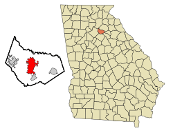
Location in Barrow County and the state of Georgia
Country United States
State Georgia
County Barrow
Area
 • Total 14.17 sq mi (36.70 km2)
 • Land 13.69 sq mi (35.44 km2)
 • Water 0.48 sq mi (1.26 km2)
Elevation
988 ft (301 m)
Population
 (2020)
 • Total 18,338
 • Density 1,340.01/sq mi (517.36/km2)
Time zone UTC-5 (Eastern (EST))
 • Summer (DST) UTC-4 (EDT)
ZIP code
30680
Area code(s) 470/678/770
FIPS code 13-83420
GNIS feature ID 0325442

Winder (pronounced WINE-der) is a city and the county seat of Barrow County, Georgia, United States. It is located east of Atlanta and is part of the Atlanta metropolitan area. The population was 14,099 at the 2010 census.

History

Winder was a place for early settlement, being first occupied hundreds of years ago by Creek Indians, who called it Snodon. Activities centered around what are now Athens and Church streets. When white settlers established homes and farms near that village in 1793, the town was renamed, becoming The Jug, and, ten years later; Jug Tavern. At that time, the town had a population of 37 persons. The first school was built on 11.5 acres, known as the Academy Lot, located at the intersection of West Athens and Church streets. An historic marker now commemorates the site. For protection from hostile Indians, Fort Yargo was constructed, one of four such forts built in the area by the Humphrey brothers.

Jug Tavern grew slowly during the decades before the Civil War. The town, at the time of its origin, extended from the railroad crossing of Broad Street (then known as Jefferson Road) for one-half mile into three counties: Jackson, Walton and Gwinnett. In 1884, Jug Tavern was incorporated by the Georgia General Assembly. It was first governed by a mayor and four aldermen who were elected annually. The first mayor, N. J. Kelly, took the oath of office on January 8, 1885.

During the Civil War, Jug Tavern was largely untouched, though a number of its young men fought in several battles. Towards the end of that conflict, however, as the northern armies of General William T. Sherman approached, two important skirmishes took place nearby; first in the fight known as the Battle of Jug Tavern in July 1864, and, during the following month, the Battle of King's Tanyard.

That decade and the next were pivotal in Winder's history. The city began to achieve prominence with the construction of railroads. The Gainesville Midland Railroad (then the Gainesville, Jefferson and Southern Railroad) built tracks through Jug Tavern along Midland Avenue in 1883, connecting it with Gainesville and Social Circle, with other stops at Bethlehem and Mulberry. The Georgia, Carolina and North Railroad (later to be merged with the Seaboard Air Line Railrway) was planned to pass four miles south of Jug Tavern, but enterprising local citizens deeded 16 acres for $10 to induce the railroad to pass through the town, which it first did on April 24, 1892, with 150 passengers on board. Jug Tavern henceforth became a station on the Atlanta and Athens run, and a depot was erected that year. Most of the early commercial activity which came to the heart of Downtown was located between these two rail lines.

Ten years after the arrival of the first Georgia, Carolina and North Railroad passenger train, Jug Tavern was again renamed; this time as the City of Winder. Local officials approved the name change in 1893, and the change became official by an Act passed by the Georgia General Assembly on December 24, 1894. Named for the general manager of the Seaboard Railway, John H. Winder, the City's boundary was enlarged to encompass a one-mile circle extending from the same crossing of the railroad of Broad Street. Similar to Jug Tavern, the town was governed by a mayor, but now with six aldermen, who had the power to issue bonds for public schools, water works and other purposes. The last mayor of Jug Tavern and the first of Winder was H. S. Segars.

Considerable growth took place in Winder during the 1890s. As the 20th century arrived, banks had been established as well as offices for attorneys, doctors, dentists, undertakers, real estate operations and blacksmiths. A drugstore came into existence and, in 1900, the Winder Telephone Company opened. While farming remained the chief occupation of most of the area's citizens, many residents began working in newly forming manufacturing enterprises, including Winder Foundry and Machinery, Bell Overall, Smith Hardware and Winder Cotton Mill (later the Winder Rug Mill). Retailing also grew in downtown: general merchandisers, drugstores, dry goods, sundries and bakeries. Four churches were constituted, a hotel was built, and a volunteer fire department was formed. Increasingly, Winder became an important trade center in eastern Georgia.

Being situated in three counties caused continuous legal problems and governance confusion for the residents and businesses of Winder. It required almost 75 years, following many aborted efforts, for Barrow County to be established. Finally, on July 7, 1914, the Georgia General Assembly carved territory from Gwinnett, Jackson and Walton counties to create the new county, with Winder as the County seat. Each of these counties utilized a river as the line which would separate the donated land in the former counties from the future Barrow County. The new county was named for the Chancellor of the University of Georgia, David Crenshaw Barrow. A new courthouse, designed by James J. Baldwin, was completed in 1920 at a cost of $133,400; the building is now listed on the National Register of Historic Places. Other towns brought in with the establishment of Barrow County included Auburn, Bethlehem, Carl and Statham.

Winder continued to prosper during most of the first half of the 20th century. Industries undertook the manufacture of overalls, hardware, textiles and the processing of cotton. Additional banks opened and, in 1907, the Winder News began publishing. After World War I, during which Winder contributed many young men, major public investments were made, including the paving of Broad Street, creation of an electric light system and construction of a waterworks. Highway 29 was paved from Lawrenceville to Winder in 1930, and, during the following year, a nearby local resident, Richard Russell Jr., was inaugurated as governor of Georgia. Later, upon his election to the U.S. Senate, Russell obtained an appropriation, in 1943, to construct a local airport, which was opened in 1948.

Many important events helped to modernize Winder after World War II. Major public improvements led this modernization, including the Winder-Barrow County Hospital, the groundbreaking ceremony taking place in August 1950. Construction was begun on the new Federal Building, which opened in 1967, the same year which saw Fort Yargo become a Georgia State Park. During the late 1970s, important investments were made in Downtown, including the restoration of the depot, improvements to downtown sidewalks, and renovation of City Hall and the police and fire stations. Following a fire that destroyed two buildings at Broad and Candler streets, the City created a small park and parking lot on the site. Plans were drawn for a civic center and new police and fire facilities, which were completed in 1986. A new headquarters for the Piedmont Regional Library was dedicated in 1988, and the new Barrow County Courthouse annex was opened in 1990. That year, Winder was a City of 7,373 inhabitants.

All of these accomplishments were celebrated by the citizens of Winder in 1993, with the commemoration of the City's 100th anniversary. A bronze marker was attached to the Winder City Hall by Mayor Buddy Outzs, which read: "To commemorate 100 years as the City of Winder, 1893-1993."

Fort Yargo was built circa 1792 as a means of protection from the native Creek Indians, one of four forts built in the area by the Humphrey brothers. The others were Fort Strong at Talasee, Fort Thomocoggan at Jefferson and Fort Groaning Rock at Commerce. The land was then part of Franklin County; it later was part of Jackson and then Walton counties before becoming a part of Barrow County. The building is a two-story log blockhouse measuring about 18 by 22 feet. Hand-hewn logs about 10 inches thick were used to construct the fort with wooden pegs used as fastenings. The logs are joined at the corners by interlocking wedge-shaped notches. Portholes were installed to be used in defense of the fort, and three springs furnish water.

Before 1800, Fort Yargo was inhabited by a small detachment of settlers who were well-armed and ready to aid their neighbors in nearby communities. In 1810, George Humphrey, one of the builders of the Fort, sold Fort Yargo and 121 acres of the surrounding land to John Hill for $167. The fort and surrounding wilderness are now part of Fort Yargo State Park.

Unsuccessful attempts to form a new county with Jug Tavern as the county seat were initiated as early as 1835 and again in 1855-56. Efforts came to a halt for a number of years in 1877, when the newly adopted State Constitution specified that no new counties be created for a quarter of a century. In 1904, several new counties were formed, and an effort was made to form a new county around Winder.

An unusual situation existed in Winder. The counties of Jackson, Gwinnett and Walton came together in the center of town. (The site is marked today and is located across Athens Street from the courthouse.) This created a great deal of confusion, as is illustrated in local legend:

Two local men became involved in a fight. One of the men, standing in Gwinnett County, shot another man who was standing in Jackson County. The unhappy victim of this affair fell and died in Walton County (Ingram, p. 16).

In 1905, there was an effort made to form the new county, centered in Winder called Stephens. This effort was not successful, but the people of Toccoa were successful in creating the new Stephens County in their area. In 1911, a bill to create Barrow County was introduced in the General Assembly. It passed the Senate unanimously but was defeated in the House. in 1913, it passed the House but was defeated in the Senate. In a reconsideration move, however, it passed 36 to 34. The bill rested until the next session, and on July 7, 1914, Governor John M. Slaton signed the Constitutional Amendment creating Barrow County.

Barrow County was named for David Crenshaw Barrow, chancellor of the University of Georgia.

Geography

Winder is located in central Barrow County at 33°59′47″N 83°43′15″W / 33.99639°N 83.72083°W / 33.99639; -83.72083 (33.996495, -83.720873). It is 20 miles (32 km) west of Athens and 50 miles (80 km) northeast of downtown Atlanta.

According to the United States Census Bureau, the city has a total area of 12.9 square miles (33.5 km2), of which 12.4 square miles (32.2 km2) is land and 0.50 square miles (1.3 km2), or 3.97%, is water.

Demographics

Historical population
Census Pop.
1890 202
1900 1,145 466.8%
1910 2,443 113.4%
1920 3,335 36.5%
1930 3,288 −1.4%
1940 3,974 20.9%
1950 4,604 15.9%
1960 5,555 20.7%
1970 6,605 18.9%
1980 6,705 1.5%
1990 7,373 10.0%
2000 10,201 38.4%
2010 14,099 38.2%
2020 18,338 30.1%
U.S. Decennial Census

2020 census

Winder racial composition
Race Num. Perc.
White (non-Hispanic) 10,787 58.82%
Black or African American (non-Hispanic) 3,746 20.43%
Native American 25 0.14%
Asian 546 2.98%
Pacific Islander 3 0.02%
Other/Mixed 929 5.07%
Hispanic or Latino 2,302 12.55%

As of the 2020 United States census, there were 18,338 people, 5,799 households, and 3,885 families residing in the city.

2010 census

As of the census of 2010, there were 14,391 people, 4,693 households, and 3,599 families residing in the city. The population density was 941.5 people per square mile (363.3/km2). There were 4,098 housing units at an average density of 378.2 per square mile (146.0/km2). The racial makeup of the city was 71.8% White, 18.2% African American, 0.25% Native American, 2.0% Asian, 0.1% Pacific Islander, 1.72% from other races, and 2.8% from two or more races. Hispanic or Latino of any race were 9.8% of the population.

There were 4,693 households, out of which 34.2% had children under the age of 18 living with them, 45.7% were married couples living together, 17.5% had a female householder with no husband present, and 32.1% were non-families. 27.3% of all households were made up of individuals, and 12.2% had someone living alone who was 65 years of age or older. The average household size was 2.53 and the average family size was 3.07.

In the city, the population was spread out, with 26.3% under the age of 18, 9.5% from 18 to 24, 30.9% from 25 to 44, 19.1% from 45 to 64, and 14.2% who were 65 years of age or older. The median age was 34 years. For every 100 females, there were 90.1 males. For every 100 females age 18 and over, there were 83.9 males.

The median income for a household in the city was $35,924, and the median income for a family was $40,896. Males had a median income of $31,371 versus $21,736 for females. The per capita income for the city was $17,108. About 10.3% of families and 13.1% of the population were below the poverty line, including 14.3% of those under age 18 and 16.8% of those age 65 or over.

It has a variety of retail establishments and restaurants, especially in a new trade area that was recently annexed into the City known as The Gateway. "The Gateway" at University Parkway is a 130-acre retail development that's home of AMC (Previously Carmike) Gateway Cinemas and multiple restaurants and retail establishments. University Parkway. In November 2011, Winder residents approved Sunday alcohol sales, becoming one of the first cities in Georgia to lift the ban.

Arts and culture

National Register of Historic Places

The county courthouse in Winder was built in 1920, and is listed under the National Register of Historic Places.

Museums

The Barrow County Museum is located in the old Barrow County Jail, built around 1915. It features a hanging tower and jail cells.

Education

Public schools

Public schools are part of the Barrow County School District and include Winder-Barrow High School. The district consists of eight elementary schools, four middle schools, and two high schools. The district has 610 full-time teachers and over 9,362 students. The following is a list of schools featured in Winder.

  • Holsenbeck Elementary School
  • Kennedy Elementary School
  • Yargo Elementary School
  • Bramlett Elementary School
  • Westside Middle School
  • Richard B. Russell Middle School
  • Haymon-Morris Middle School
  • Winder-Barrow High School
  • Apalachee High School
  • Sims Academy of Innovation and Technology

Former Schools

  • Winder-Barrow Middle School (closed 2013)
  • Snodon Preparatory School (closed 2014)

Private schools

  • Bethlehem Christian Academy
  • B.C.C.A Barrow County Christian Academy

Colleges and universities

  • Lanier Technical College - (Winder-Barrow Campus)

Transportation

Major roads

  • Georgia 8.svg State Route 8
  • Georgia 11.svg State Route 11
  • US 29.svg U.S. Route 29
  • Georgia 53.svg State Route 53
  • Georgia 81.svg State Route 81
  • Georgia 82.svg State Route 82
  • Georgia 211.svg State Route 211

Pedestrians and cycling

There are limited walkability options available currently. However, neighboring Clarke, Gwinnett and Hall counties have accessible trails available.

See also

Kids robot.svg In Spanish: Winder para niños

kids search engine
Winder, Georgia Facts for Kids. Kiddle Encyclopedia.