
Walton County, Georgia facts for kids
Quick facts for kids
Walton County
|
|||
|---|---|---|---|

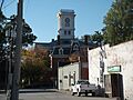
Walton County courthouse in Monroe
|
|||
|
|||

Location within the U.S. state of Georgia
|
|||
 Georgia's location within the U.S. |
|||
| Country | |||
| State | |||
| Founded | December 22, 1818 | ||
| Named for | George Walton | ||
| Seat | Monroe | ||
| Largest city | Monroe | ||
| Area | |||
| • Total | 330 sq mi (900 km2) | ||
| • Land | 326 sq mi (840 km2) | ||
| • Water | 4.3 sq mi (11 km2) 1.3%% | ||
| Population
(2020)
|
|||
| • Total | 96,673 | ||
| • Density | 297/sq mi (115/km2) | ||
| Time zone | UTC−5 (Eastern) | ||
| • Summer (DST) | UTC−4 (EDT) | ||
| Congressional district | 10th | ||


Walton County is a place in the middle part of Georgia. It's like a big neighborhood or district. In 2020, about 96,673 people lived there. The county is about 30 miles east of Atlanta, which is Georgia's capital city.
Monroe is the main town, also called the county seat. Loganville is another important city in Walton County. This county is also part of the larger Atlanta area.
Contents
History of Walton County
Walton County was officially created on December 15, 1818. It was named after George Walton. He was one of the three people from Georgia who signed the United States Declaration of Independence. The other two signers from Georgia were Button Gwinnett and Lyman Hall.
Many important people have lived in Walton County. Seven governors of Georgia were either born there or called it home. These governors include Wilson Lumpkin, Howell Cobb, and Richard Russell, Jr..
Geography and Nature
Walton County covers a total area of about 330 square miles. Most of this area, about 326 square miles, is land. The rest, about 4.3 square miles, is water.
The western part of Walton County is in the Ocmulgee River area. This river flows into the larger Altamaha River. The eastern part of the county is in the Oconee River area, which also flows into the Altamaha River.
Main Roads and Highways
Many important roads run through Walton County. These roads help people travel easily to other parts of Georgia.
 Interstate 20
 U.S. Route 78
 U.S. Route 278
 State Route 10
 State Route 10 Business
 State Route 11
 State Route 12
 State Route 20
 State Route 81
 State Route 83
 State Route 138
 State Route 186
 State Route 402 (This is the official name for I-20)
Neighboring Counties
Walton County shares its borders with several other counties:
- Barrow County to the north
- Oconee County to the northeast
- Morgan County to the southeast
- Newton County to the south
- Rockdale County to the southwest
- Gwinnett County to the northwest
Towns and Cities
Walton County has several communities where people live.
Cities
Towns
Other Communities
These are smaller places that are not officially cities or towns:
- Bold Springs
- Campton
- Gratis
- Mt. Vernon
- Pannell
- Windsor
- Youth
People of Walton County
The number of people living in Walton County has changed a lot over time. From 1900 to 1960, many African American families moved away. They went to cities in the North and West. This was part of a big movement called the Great Migration. People moved to find better jobs and opportunities.
Today, Walton County is growing quickly because it is near Atlanta. Many new homes and shops have been built. The population is now mostly white.
| Historical population | |||
|---|---|---|---|
| Census | Pop. | %± | |
| 1810 | 1,026 | — | |
| 1820 | 4,192 | 308.6% | |
| 1830 | 10,929 | 160.7% | |
| 1840 | 10,209 | −6.6% | |
| 1850 | 10,821 | 6.0% | |
| 1860 | 11,074 | 2.3% | |
| 1870 | 11,038 | −0.3% | |
| 1880 | 15,622 | 41.5% | |
| 1890 | 17,467 | 11.8% | |
| 1900 | 20,942 | 19.9% | |
| 1910 | 25,393 | 21.3% | |
| 1920 | 24,216 | −4.6% | |
| 1930 | 21,118 | −12.8% | |
| 1940 | 20,777 | −1.6% | |
| 1950 | 20,230 | −2.6% | |
| 1960 | 20,481 | 1.2% | |
| 1970 | 23,404 | 14.3% | |
| 1980 | 31,211 | 33.4% | |
| 1990 | 38,586 | 23.6% | |
| 2000 | 60,687 | 57.3% | |
| 2010 | 83,768 | 38.0% | |
| 2020 | 96,673 | 15.4% | |
| 2023 (est.) | 106,702 | 27.4% | |
| U.S. Decennial Census 1790-1880 1890-1910 1920-1930 1930-1940 1940-1950 1960-1980 1980-2000 2010 2020 |
|||
In 2020, there were 96,673 people living in Walton County. There were 33,350 households, which are groups of people living together. Also, there were 25,736 families.
Education in Walton County
Most students in Walton County go to schools in the Walton County School District. However, if you live in Social Circle, you would go to the Social Circle City School District.
Images for kids
-
Walton County courthouse in Monroe
See also
 In Spanish: Condado de Walton (Georgia) para niños
