
Norcross, Georgia facts for kids
Quick facts for kids
Norcross, Georgia
|
|||
|---|---|---|---|

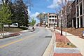
Downtown Norcross
|
|||
|
|||
| Motto(s):
"A place to Imagine"
|
|||
| Country | United States | ||
| State | Georgia | ||
| County | Gwinnett | ||
| Government | |||
| Area | |||
| • Total | 6.17 sq mi (15.99 km2) | ||
| • Land | 6.15 sq mi (15.93 km2) | ||
| • Water | 0.02 sq mi (0.06 km2) | ||
| Elevation | 974 ft (297 m) | ||
| Population
(2020)
|
|||
| • Total | 17,209 | ||
| • Density | 2,797.76/sq mi (1,080.18/km2) | ||
| Time zone | UTC-5 (Eastern (EST)) | ||
| • Summer (DST) | UTC-4 (EDT) | ||
| ZIP codes |
30003, 30010, 30071, 30091, 30093, 30097
|
||
| Area code(s) | 770, 678, 470 | ||
| FIPS code | 13-55776 | ||
| GNIS feature ID | 2404384 | ||


Norcross is a city located in Gwinnett County, Georgia, United States. It is part of the larger Atlanta region. In 2010, about 9,116 people lived in Norcross. By 2020, the population grew to 17,209 people. The city's motto is "A place to Imagine."
Contents
History of Norcross

Norcross officially became a town on October 26, 1870. The city was named after Jonathan Norcross. He was a former mayor of Atlanta and also worked for the railroad.
Geography and Location
Norcross is located in the state of Georgia. To the north, it shares a border with the city of Peachtree Corners. The southern edge of Norcross is along Interstate 85. You can get to Norcross from this highway using Exits 99, 101, and 102.
Downtown Atlanta is about 20 miles (32 km) southwest of Norcross. You can reach Atlanta easily using Interstate 85. The city of Norcross covers a total area of about 6.17 square miles (15.99 square kilometers). Most of this area is land, with a very small part being water.
People and Population
Norcross has grown quite a bit over the years. In 1880, about 500 people lived there. By 2020, the population had grown to 17,209 people. The city is home to a diverse group of people from many different backgrounds.
Education in Norcross
Norcross has many schools for students of all ages. Gwinnett County Public Schools manages the public schools in the area.
Elementary Schools
- Susan O. Stripling Elementary School
- Beaver Ridge Elementary School
- Meadowcreek Elementary School
- Nesbit Elementary School
- Norcross Elementary School
- Rockbridge Elementary School
- Baldwin Elementary School
Middle Schools
- Pinckneyville Middle School
- Summerour Middle School
High Schools
- Meadowcreek High School
- Norcross High School
- Paul Duke STEM High School (This is an alternative school focusing on science, technology, engineering, and math)
- McClure Health Science High School (Another alternative school, focused on health sciences)
Other Schools and Colleges
- Brenau University Atlanta Campus (a private college)
- Greater Atlanta Christian School (a private school)
- GIVE Center West (an alternative school)
- Ashworth College (an online university)
Gwinnett County Public Library also has a branch in Norcross.
Local Economy
Norcross is home to several interesting companies. These businesses provide many jobs for the people living in the city.
- RentPath: A company that helps people find apartments.
- Institute of Industrial Engineers: A group for engineers who work on making things more efficient.
- LSI Corporation: This company designs computer chips and software for data centers and mobile phones.
- EMS Technologies: They specialize in wireless communication technology.
- Waffle House: The main office for this popular restaurant chain is in Norcross.
- NanoLumens: This company designs and makes large digital LED screens.
Media and Filming
The main newspaper for the wider Atlanta area is the Atlanta Journal-Constitution.
Norcross has also been a filming location for television shows. The ABC Studios show Resurrection was filmed in the town square and other parts of Norcross. Also, All Elite Wrestling filmed some of their TV shows at a training facility in Norcross during the COVID-19 epidemic.
Transportation and Travel
Norcross is connected by several important roads and has public transportation options.
Major Roads
 U.S. Route 23
 Interstate 85
 State Route 140
 State Route 141
 Interstate 285 (This highway is about 1.5 miles from Gwinnett Village)
 State Route 378
Transit Systems
- Gwinnett County Transit provides bus services in the city.
- The Norcross Greyhound Bus Terminal is located at 2105 Norcross Pkwy.
Walking and Biking Paths
The West Gwinnett Bikeway is a path for walking and cycling. It runs along Peachtree Industrial Boulevard. This path connects Norcross to the nearby city of Duluth.
In 2015, Norcross also started planning a greenway along Beaver Ruin Creek. This path could connect Norcross residents to the Peachtree Creek Greenway being built in other parts of Atlanta.
Notable People from Norcross
Many talented people have come from Norcross, especially in sports.
- Jake Camarda: An NFL punter for the Tampa Bay Buccaneers.
- Jason Croom: An NFL tight end.
- Chris Herndon: An NFL tight end for the New Orleans Saints.
- Alvin Kamara: An NFL running back for the New Orleans Saints.
- Davis Mills: An NFL quarterback for the Houston Texans.
- Malcolm Brogdon: An NBA player for the Portland Trail Blazers.
- Brandon Boston: An NBA player for the Los Angeles Clippers.
- Wesley Duke: An NFL tight end for the Denver Broncos.
Images for kids
-
Downtown Norcross
-
Flag of Norcross
-

Logo of Norcross
See also
 In Spanish: Norcross (Georgia) para niños
