Fairburn, Georgia facts for kids
Quick facts for kids
Fairburn, Georgia
|
|||
|---|---|---|---|

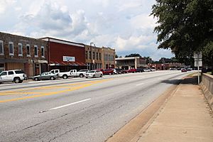
Downtown Fairburn
|
|||
|
|||
| Motto(s):
"Situated to Succeed"
|
|||

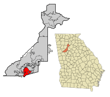
Location in Fulton County and the state of Georgia
|
|||
| Country | United States | ||
| State | Georgia | ||
| County | Fulton | ||
| Government | |||
| • Type | Mayor–council government | ||
| Area | |||
| • Total | 17.12 sq mi (44.34 km2) | ||
| • Land | 16.91 sq mi (43.79 km2) | ||
| • Water | 0.21 sq mi (0.55 km2) | ||
| Elevation | 1,027 ft (313 m) | ||
| Population
(2020)
|
|||
| • Total | 16,483 | ||
| • Density | 974.86/sq mi (376.40/km2) | ||
| • Demonym | Fairburnite | ||
| Time zone | UTC-5 (Eastern (EST)) | ||
| • Summer (DST) | UTC-4 (EDT) | ||
| ZIP code |
30213
|
||
| Area code(s) | 770 | ||
| FIPS code | 13-28380 | ||
| GNIS feature ID | 2403586 | ||
Fairburn is a city in Fulton County, Georgia, USA. In 2020, about 16,483 people lived there. It's like a neighbor to Atlanta, which is only 17 miles north. Fairburn has its own interesting past, but it's also connected to the bigger city of Atlanta.
Contents
What's in a Name?
Fairburn got its name from a place called Fairburn in England.
A Look at Fairburn's History
Fairburn is located along a railroad line. It became the main town, or county seat, for Campbell County in 1871.
Why Fairburn Became the County Seat
Before Fairburn, the county seat was Campbellton. But in the 1850s, Campbellton didn't want the Atlanta and West Point Railroad to pass through because of the noise. So, the railroad went through Fairburn instead.
- Because of the railroad, Fairburn started to grow.
- Campbellton, without the railroad, slowly became less important.
- In 1871, people voted, and Fairburn was chosen as the new county seat.
Fairburn During the Great Depression
During the Great Depression in 1931, the government of Campbell County ran out of money. Because of this, Campbell County joined with Fulton County in 1932.
- In 1870, Fairburn had 305 people living there.
- Out of those, 208 were white residents and 97 were black residents.
Where is Fairburn Located?
Fairburn is right next to Interstate 85.
- This highway goes northeast about 20 miles (32 km) to downtown Atlanta.
- It also goes southwest about 142 miles (229 km) to Montgomery, Alabama.
- Georgia State Route 74 also runs through Fairburn.
- This route goes south about 13 miles (21 km) to Peachtree City.
- Some areas in nearby Fayette County also use a Fairburn mailing address.
Fairburn's Size
According to the 2010 census, Fairburn covers a total area of about 17.1 square miles (44.3 km2).
- Most of this area, about 16.9 square miles (43.8 km2), is land.
- A small part, about 0.2 square miles (0.5 km2) or 1.24%, is water.
Who Lives in Fairburn?
Let's look at how Fairburn's population has grown over the years.
| Historical population | |||
|---|---|---|---|
| Census | Pop. | %± | |
| 1860 | 298 | — | |
| 1870 | 305 | 2.3% | |
| 1880 | 563 | 84.6% | |
| 1890 | 695 | 23.4% | |
| 1900 | 761 | 9.5% | |
| 1910 | 1,395 | 83.3% | |
| 1920 | 1,600 | 14.7% | |
| 1930 | 1,372 | −14.2% | |
| 1940 | 1,502 | 9.5% | |
| 1950 | 1,889 | 25.8% | |
| 1960 | 2,470 | 30.8% | |
| 1970 | 3,143 | 27.2% | |
| 1980 | 3,466 | 10.3% | |
| 1990 | 4,013 | 15.8% | |
| 2000 | 5,464 | 36.2% | |
| 2010 | 12,950 | 137.0% | |
| 2020 | 16,483 | 27.3% | |
| U.S. Decennial Census 1850-1870 1870-1880 1890-1910 1920-1930 1940 1950 1960 1970 1980 1990 2000 2010 |
|||
Fairburn's Population in 2020
In 2020, the 2020 United States census counted 16,483 people living in Fairburn. There were 5,051 households and 3,442 families.
| Race | Num. | Perc. |
|---|---|---|
| White (non-Hispanic) | 1,540 | 9.34% |
| Black or African American (non-Hispanic) | 12,601 | 76.45% |
| Native American | 16 | 0.1% |
| Asian | 220 | 1.33% |
| Pacific Islander | 4 | 0.02% |
| Other/Mixed | 454 | 2.75% |
| Hispanic or Latino | 1,648 | 10.0% |
Learning and Libraries
Fairburn has several options for education, from elementary school all the way to college.
Schools for Kids
- Fulton County Schools is the public school system that serves Fairburn.
- There are also private schools:
- Arlington Christian School
- Landmark Christian School
Colleges and Universities
- Brenau University has a smaller campus in Fairburn.
- Georgia Military College also has a campus here, where students can earn associate degrees.
Public Libraries
- The Atlanta-Fulton Public Library System runs the Fairburn Branch. It's a great place to find books and learn!
Fun and Culture in Fairburn
Fairburn is known for its exciting events and festivals.
- The Georgia Renaissance Festival happens in Fairburn every spring. It's a fun event where you can step back in time to the days of knights and queens!
- The city of Fairburn also hosts the "Fairburn Festival" each fall. This festival includes a parade, local food, crafts, and live music.
See also
 In Spanish: Fairburn (Georgia) para niños
 | Aaron Henry |
 | T. R. M. Howard |
 | Jesse Jackson |


