
BeltLine facts for kids
| Script error: The function "autoWithCaption" does not exist. | |
| Formation | April 2005 (21 years ago) |
|---|---|
| Legal status | Georgia non-profit |
| Purpose | Urban redevelopment and mobility |
| Location |
|
|
President and Chief Executive Officer (ABI,) Executive Director (ABP)
|
Clyde Higgs (ABI) Rob Brawner (ABP) |
|
Main organ
|
Atlanta BeltLine Inc. (ABI) and Atlanta BeltLine Partnership (ABP) |
| Website | beltline.org |
Script error: No such module "Check for conflicting parameters".
The Atlanta BeltLine is an exciting project in Atlanta, Georgia. It's built on old railway tracks that circle the city. This project is turning those tracks into a cool multi-use trail for walking, running, and biking. Some parts are already finished and ready to explore, while others are still being built.
The main goals of the BeltLine are to make it easier to get around Atlanta, add more beautiful green spaces like parks, and help new businesses and homes grow in the city. There are also plans to add streetcars or light-rail trains along some parts of the path in the future.
The idea for the BeltLine came from a student named Ryan Gravel in 1999. He thought it would be great to connect Atlanta's parks and neighborhoods using these old railway lines. The project has also been used for fun temporary art displays. In 2013, it received a big grant of $18 million to help build the southwest part. In 2019, another $6 million was given to connect the BeltLine to the Silver Comet Trail. When finished, this will create one of the longest paved trails in the U.S., stretching about 300 miles (480 km)!
Contents
History of the BeltLine
From Railroad to Trail
The story of the BeltLine began with railroads. In the late 1800s, a railroad company started building a connecting rail line in Atlanta. Soon after, in 1899, a bigger plan was announced for an "Atlanta Belt Railway Company." This company wanted to build a railway that would circle the entire city. It would connect all the different rail lines, making it easier to move freight cars without going through downtown Atlanta.
This railway line, about 22 miles (35 km) long, was finished by 1902. It helped Atlanta grow as a transportation hub.
The Idea for Transformation
The exciting idea to turn these old rail lines into a ring of trails and parks came from Ryan Gravel. He was a student at Georgia Tech in 1999. He was frustrated that Atlanta didn't have many ways to get around besides cars. So, he wrote his master's thesis about this amazing idea.
Ryan and his friends shared his idea with important people in Atlanta. Many leaders, including former Atlanta mayor Shirley Franklin, loved the concept. The idea quickly gained support in 2003 and 2004.
The old railroad tracks were owned by different companies and the Georgia Department of Transportation. In 2005, the Atlanta BeltLine Partnership was formed. Then, in 2006, Atlanta BeltLine, Inc. was created, and work officially began to develop the project.

Connecting to the Silver Comet Trail
In September 2019, the James M. Cox Foundation gave $6 million to the PATH Foundation. This money will help connect the Silver Comet Trail to the Atlanta BeltLine. This connection is expected to be finished by 2022. Once it's done, the combined trails will be about 300 miles (480 km) long. This will make it the longest paved trail system in the United States!
BeltLine Trails and Route

The BeltLine will have a continuous path that goes all the way around the central part of Atlanta. It mostly follows the old railroad paths. In total, about 33 miles (53 km) of multi-use paths will be built. This includes smaller trails that connect to nearby neighborhoods. The BeltLine will link 45 different neighborhoods, including some that didn't have many parks before.
As of mid-2017, several parts of the trail were already finished:
- Eastside Trail
- Northside Trail
- Southwest Connector Trail
- West End Trail
- Westside Trail
There are also temporary hiking trails in other areas.
Eastside Trail
The Eastside Trail goes from Piedmont Park in the north to Inman Park and Old Fourth Ward in the south. This part of the trail passes by many old industrial buildings. These buildings have been changed into cool new homes, shops, restaurants, and offices. A great example is Ponce City Market.
Westside and West End Trails
The very first trail built on the BeltLine was the 2.4-mile (3.9 km) West End Trail. It opened in 2008. This trail goes along the West End neighborhood and also serves Mozley Park and Westview.
The Westside Trail opened in September 2017. It is three miles (4.8 km) long and uses the old railroad path. It stretches from Washington Park in the north to University Avenue in Adair Park.
Northside Trail
The first part of the Northside Trail opened in 2010. It's part of a bigger network of trails in the northern part of the city, near Tanyard Creek Park. An extra section, called the Northside Spur Trail, opened in 2015. This trail will eventually connect to other trails like the Peachtree Creek Greenway and the PATH400.
Southwest Connector Trail
The Southwest Connector Spur Trail goes through wooded areas. It starts at the Lionel Hampton Trail and ends at Westwood Avenue. This trail serves the Beecher Hills and Westwood Terrace neighborhoods. The existing 1.15-mile (1.85 km) trail is planned to be part of a longer 4.5-mile (7.2 km) trail.
Gaps in the BeltLine


There are five places along the BeltLine where the paths don't connect yet. These "gaps" are challenging to build because of active rail lines or other obstacles. Engineers and planners are working on solutions for these areas. For example, they might need to build tunnels, widen bridges, or share space with existing roads or train tracks.
Parks Along the BeltLine
The BeltLine plan includes creating many new parks and improving existing ones. This will create what's called the "BeltLine Jewels"—13 parks connected by the trail. In total, the BeltLine project will create or improve about 1,300 acres (5.3 km²) of green space. That's a huge increase in parks for Atlanta!
Some existing parks will be made much larger:
- Enota Park will grow from 0.3 acres to 10 acres (0.12 to 0.04 km²).
- Maddox Park will grow from 52 acres to 114 acres (0.21 to 0.46 km²).
- Ardmore Park will grow from 2 acres to 8 acres (0.008 to 0.032 km²).
New parks will also be created, including:
- Peachtree Creek Park (65 acres or 0.26 km²)
- Historic Fourth Ward Park (63 acres or 0.25 km²)
- Waterworks Park (204 acres or 0.83 km²)
- Westside Park (351 acres or 1.42 km²) – This park will be about twice the size of Piedmont Park! It's being built on the site of an old quarry, which will become a reservoir.
A non-profit group called The Trust for Public Land has helped by buying 33 properties. These properties, totaling 1,300 acres, will add almost 40% more green space to Atlanta.
Transit Plans
One of the original ideas for the BeltLine was to have a 22-mile (35 km) light rail loop around the city. While the project has grown to include trails and parks, the idea of transit is still important.
In 2012, there was a vote on whether to add a 1-cent sales tax to pay for traffic and road improvements. If it had passed, this tax would have helped fund streetcar routes along parts of the BeltLine. However, the sales tax did not pass.
More recently, the 2018 MARTA spending plan includes extending Atlanta Streetcar tracks. These tracks will be added to two separate sections of the BeltLine. This means that light rail trains could eventually run on these parts of the old railway corridor.
Art on the BeltLine
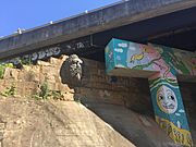
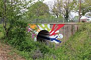
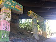
"Art on the Atlanta BeltLine" is a huge temporary public art show in the city. It displays the work of many artists, performers, and musicians along about 9 miles (14 km) of the BeltLine. The first show was in 2010. You can also find lots of cool, unofficial street art along the BeltLine, like murals and sculptures.
- Examples of BeltLine Art incl. Street Art
-
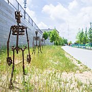
Sculptures along the BeltLine
-
-
"The Highball Artist" by Hadley Breckenridge on the Lucile Avenue Bridge
-
Street Art
-

Street Art
-

Street Art


Cool Old Buildings

Many old industrial buildings next to the BeltLine, especially along the Eastside Trail, have been given new life. They used to be factories or warehouses, but now they are apartments, shops, and restaurants. Some famous examples include Ponce City Market (which used to be a Sears warehouse), the Krog Street Market, and the Telephone Factory Lofts. These buildings add a unique and historic feel to the BeltLine experience.
