Conley, Georgia facts for kids
Quick facts for kids
Conley
|
|
|---|---|

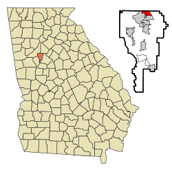
Location in Clayton County and the state of Georgia
|
|
| Country | United States |
| State | Georgia |
| County | Clayton, Fulton |
| Area | |
| • Total | 1.94 sq mi (5.03 km2) |
| • Land | 1.92 sq mi (4.98 km2) |
| • Water | 0.02 sq mi (0.05 km2) |
| Elevation | 853 ft (260 m) |
| Population
(2020)
|
|
| • Total | 6,680 |
| • Density | 3,475.55/sq mi (1,341.87/km2) |
| Time zone | UTC-5 (Eastern (EST)) |
| • Summer (DST) | UTC-4 (EDT) |
| ZIP code |
30288-30354
|
| Area code(s) | 404 |
| FIPS code | 13-19280 |
| GNIS feature ID | 0331447 |
Conley is a small community in Clayton County, Georgia, United States. It's not a city but a special type of area called an "unincorporated community" and a "census-designated place" (CDP). This means it's a recognized area for counting people.
Conley is located near the southeast edge of Atlanta. It is about 8 miles (13 kilometers) from downtown Atlanta. In 2020, about 6,680 people lived there. Conley is part of the larger Atlanta metropolitan area.
Contents
History of Conley
How Conley Got Its Name
Conley was first known by a different name: Moccasin Gap. This name was used for many years.
In 1867, the community was officially named "Conley." It was named after the Conley family. They owned a lot of land in the area.
From Farms to Factories
Long ago, Conley was mostly a farming community. Many people had farms there. Today, Conley is known for its manufacturing industry. This means many companies make things there.
Geography of Conley
Where is Conley Located?
Conley is in the northern part of Clayton County. It is located at coordinates 33.640142 degrees North and 84.342255 degrees West.
It shares borders with several other places. To the south and west, it borders the city of Forest Park. To the northwest, it borders the big city of Atlanta. To the north, it borders land in DeKalb County that is not part of a city.
Conley's Size and Water Areas
The eastern edge of Conley is along U.S. Route 23. This road is also known as Moreland Avenue.
Conley covers a total area of about 5.0 square kilometers (1.9 square miles). A small part of this area is water. About 0.05 square kilometers (0.02 square miles) of Conley is water. This is about 0.98% of its total area.
Population in Conley
How Many People Live Here?
Conley has been counted as a "census-designated place" since 1980. This means the U.S. government collects population data for it.
| Historical population | |||
|---|---|---|---|
| Census | Pop. | %± | |
| 1980 | 6,033 | — | |
| 1990 | 5,528 | −8.4% | |
| 2000 | 6,188 | 11.9% | |
| 2010 | 6,228 | 0.6% | |
| 2020 | 6,680 | 7.3% | |
| U.S. Decennial Census 1850-1870 1870-1880 1890-1910 1920-1930 1940 1950 1960 1970 1980 1990 2000 2010 2020 |
|||
In 2020, the population of Conley was 6,680 people. There were 2,016 households in the area. A household is a group of people living together. There were also 1,266 families.
Economy and Businesses in Conley
Trucking and Shipping Hub
Conley is a very important place for trucking companies. Many companies that move goods by truck have facilities here. These include companies that transport smaller loads (less-than-truckload carriers). There are also places for truck parts and repairs.
Some of the well-known trucking companies in Conley include Old Dominion Freight Line, FedEx Freight, and Schneider National. Most of these businesses are located along US 23 and GA 42.
Logistics and Storage
A big global shipping company called Crowley Maritime also has a facility in Conley. They have a yard for storing and moving large shipping containers. This is called an intermodal yard. It helps move goods between different types of transportation, like trucks and trains.
Solar Energy Project
Conley is also home to the Hickory Ridge Landfill. This used to be a place where trash was buried. Now, the landfill is closed and covered. It has been turned into a solar energy project. This means it uses the sun's power to create electricity.
See also
 In Spanish: Conley para niños
 | Frances Mary Albrier |
 | Whitney Young |
 | Muhammad Ali |

