Irondale, Georgia facts for kids
Quick facts for kids
Irondale, Georgia
|
|
|---|---|

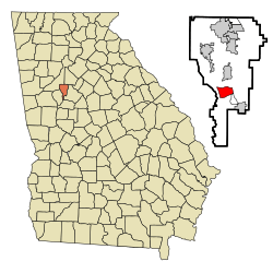
Location in Clayton County and the state of Georgia
|
|
| Country | United States |
| State | Georgia |
| County | Clayton |
| Area | |
| • Total | 3.20 sq mi (8.29 km2) |
| • Land | 3.16 sq mi (8.17 km2) |
| • Water | 0.05 sq mi (0.12 km2) |
| Elevation | 814 ft (255 m) |
| Population
(2020)
|
|
| • Total | 8,740 |
| • Density | 2,769.33/sq mi (1,069.28/km2) |
| Time zone | UTC-5 (Eastern (EST)) |
| • Summer (DST) | UTC-4 (EDT) |
| FIPS code | 13-41347 |
| GNIS feature ID | 2402621 |
Irondale is a community located in Clayton County, Georgia, in the United States. It's known as an unincorporated community and a census-designated place (CDP). This means it's a recognized area where people live, but it doesn't have its own city government. In 2020, about 8,740 people lived in Irondale.
Irondale's Location and Size
Irondale is found in the southern part of Clayton County. You can find its exact spot using coordinates: 33°28′32″N 84°21′37″W / 33.47556°N 84.36028°W.
Main roads like U.S. Route 19 and U.S. Route 41 run along its eastern side. These roads can take you about 3 miles (5 km) north to Jonesboro, which is the county seat. If you travel about 20 miles (32 km) north, you'll reach downtown Atlanta.
The total area of Irondale is about 3.2 square miles (8.3 square kilometers). Most of this area is land, with a small part, about 0.05 square miles (0.1 square kilometers), being water.
Population Changes Over Time
The number of people living in Irondale has changed quite a bit over the years.
| Historical population | |||
|---|---|---|---|
| Census | Pop. | %± | |
| 1990 | 3,352 | — | |
| 2000 | 7,727 | 130.5% | |
| 2010 | 7,446 | −3.6% | |
| 2020 | 8,740 | 17.4% | |
| U.S. Decennial Census | |||
Irondale was first officially counted as a census-designated place in the 1990 U.S. census. In 2020, there were 8,740 people living there. This included 2,298 households and 1,796 families.
Community Makeup
The community of Irondale is made up of people from many different backgrounds. Here's a look at how the population has changed over the years:
| Race / Ethnicity (NH = Non-Hispanic) | Pop 2000 | Pop 2010 | Pop 2020 | % 2000 | % 2010 | % 2020 |
|---|---|---|---|---|---|---|
| White alone (NH) | 3,482 | 1,038 | 781 | 45.06% | 13.94% | 8.94% |
| Black or African American alone (NH) | 3,601 | 4,270 | 6,079 | 46.60% | 57.35% | 69.55% |
| Native American or Alaska Native alone (NH) | 25 | 23 | 21 | 0.32% | 0.31% | 0.24% |
| Asian alone (NH) | 146 | 99 | 109 | 1.89% | 1.33% | 1.25% |
| Pacific Islander alone (NH) | 1 | 11 | 7 | 0.01% | 0.15% | 0.08% |
| Some Other Race alone (NH) | 25 | 18 | 61 | 0.32% | 0.24% | 0.70% |
| Mixed Race or Multi-Racial (NH) | 124 | 107 | 206 | 1.60% | 1.44% | 2.36% |
| Hispanic or Latino (any race) | 323 | 1,880 | 1,476 | 4.18% | 25.25% | 16.89% |
| Total | 7,727 | 7,446 | 8,740 | 100.00% | 100.00% | 100.00% |
See also
 In Spanish: Irondale (Georgia) para niños
 | Selma Burke |
 | Pauline Powell Burns |
 | Frederick J. Brown |
 | Robert Blackburn |

