Monroe County, Georgia facts for kids
Quick facts for kids
Monroe County
|
|
|---|---|

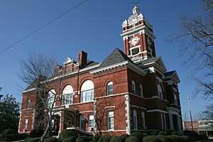
Monroe County courthouse in Forsyth
|
|

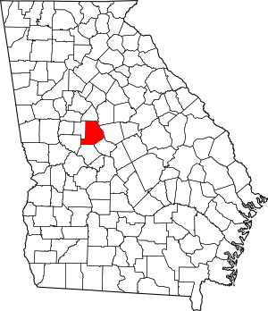
Location within the U.S. state of Georgia
|
|
 Georgia's location within the U.S. |
|
| Country | |
| State | |
| Founded | 1821 |
| Named for | James Monroe |
| Seat | Forsyth |
| Largest city | Forsyth |
| Area | |
| • Total | 398 sq mi (1,030 km2) |
| • Land | 396 sq mi (1,030 km2) |
| • Water | 2.2 sq mi (6 km2) 0.5%% |
| Population
(2020)
|
|
| • Total | 27,957 |
| • Estimate
(2023)
|
30,625 |
| • Density | 70.24/sq mi (27.12/km2) |
| Time zone | UTC−5 (Eastern) |
| • Summer (DST) | UTC−4 (EDT) |
| Congressional district | 8th |
Monroe County is a county in the central part of Georgia. It was created on May 15, 1821. The county is named after James Monroe, who was a U.S. President.
The main town and county seat is Forsyth. In 2020, about 27,957 people lived in Monroe County. It is part of the larger Macon metropolitan area.
Contents
Geography of Monroe County
Monroe County covers about 398 square miles. Most of this area is land, with a small part being water. The county is located in the Piedmont region of Georgia. This region is known for its rolling hills.
Most of Monroe County is in the Ocmulgee River basin. This means that rivers and streams in the county flow into the Ocmulgee River. A small part of the county in the southwest is in the Flint River basin.
Main Roads in Monroe County
Many important roads pass through Monroe County. These roads help people travel across the county and to other parts of Georgia.
Neighboring Counties
Monroe County shares borders with several other counties in Georgia. These are:
- Butts County (to the north)
- Jasper County (to the northeast)
- Jones County (to the east)
- Bibb County (to the southeast)
- Crawford County (to the south)
- Upson County (to the southwest)
- Lamar County (to the west)
Towns and Communities
Monroe County has several towns and smaller communities where people live.
Cities
Census-Designated Places
These are areas that are like towns but are not officially incorporated as cities.
Other Communities
These are smaller, unincorporated communities within the county.
- Berner
- Blount
- Brent
- High Falls
- Russellville
- Strouds
Population Over Time
The number of people living in Monroe County has changed a lot over the years. Here's a look at the population at different times:
| Historical population | |||
|---|---|---|---|
| Census | Pop. | %± | |
| 1830 | 16,202 | — | |
| 1840 | 16,275 | 0.5% | |
| 1850 | 16,985 | 4.4% | |
| 1860 | 15,953 | −6.1% | |
| 1870 | 17,213 | 7.9% | |
| 1880 | 18,808 | 9.3% | |
| 1890 | 19,137 | 1.7% | |
| 1900 | 20,682 | 8.1% | |
| 1910 | 20,450 | −1.1% | |
| 1920 | 20,138 | −1.5% | |
| 1930 | 11,606 | −42.4% | |
| 1940 | 10,749 | −7.4% | |
| 1950 | 10,523 | −2.1% | |
| 1960 | 10,495 | −0.3% | |
| 1970 | 10,991 | 4.7% | |
| 1980 | 14,610 | 32.9% | |
| 1990 | 17,113 | 17.1% | |
| 2000 | 21,757 | 27.1% | |
| 2010 | 26,424 | 21.5% | |
| 2020 | 27,957 | 5.8% | |
| 2023 (est.) | 30,625 | 15.9% | |
| U.S. Decennial Census |
|||
The population grew steadily until the 1920s, then dropped for a few decades. Since the 1960s, the population has been growing again. In 2020, there were 27,957 people living in the county. By 2023, the population was estimated to be over 30,000 people.
Who Lives in Monroe County?
The people of Monroe County come from many different backgrounds. The U.S. Census helps us understand the mix of people living here.
| Group | Pop 2000 | Pop 2010 | Pop 2020 | % 2000 | % 2010 | % 2020 |
|---|---|---|---|---|---|---|
| White (not Hispanic) | 15,150 | 19,101 | 19,954 | 69.63% | 72.29% | 71.37% |
| Black or African American (not Hispanic) | 6,015 | 6,249 | 6,084 | 27.65% | 23.65% | 21.76% |
| Native American (not Hispanic) | 67 | 64 | 34 | 0.31% | 0.24% | 0.12% |
| Asian (not Hispanic) | 74 | 209 | 239 | 0.34% | 0.79% | 0.85% |
| Other races (not Hispanic) | 6 | 14 | 86 | 0.03% | 0.05% | 0.31% |
| Mixed race (not Hispanic) | 158 | 248 | 846 | 0.73% | 0.94% | 3.03% |
| Hispanic or Latino (any race) | 281 | 535 | 714 | 1.29% | 2.02% | 2.55% |
| Total | 21,757 | 26,424 | 27,957 | 100.00% | 100.00% | 100.00% |
In 2020, most people in Monroe County were White (not Hispanic), followed by Black or African American (not Hispanic). There are also smaller groups of Asian, Native American, and people of mixed races. The number of Hispanic or Latino residents has also been growing.
Education in Monroe County
All schools in Monroe County are part of the Monroe County School District. This district manages public schools for all students in the county.
See also
 In Spanish: Condado de Monroe (Georgia) para niños
 | John T. Biggers |
 | Thomas Blackshear |
 | Mark Bradford |
 | Beverly Buchanan |

