Crawford County, Georgia facts for kids
Quick facts for kids
Crawford County
|
|
|---|---|

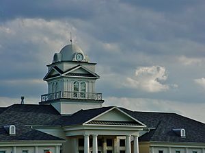
Crawford County Courthouse in Knoxville
|
|

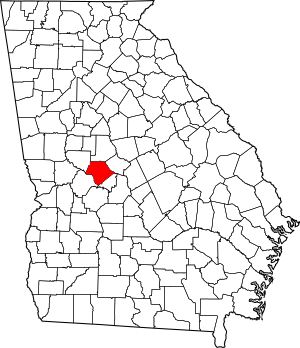
Location within the U.S. state of Georgia
|
|
 Georgia's location within the U.S. |
|
| Country | |
| State | |
| Founded | 1822 |
| Named for | William H. Crawford |
| Seat | Knoxville |
| Largest city | Roberta |
| Area | |
| • Total | 326 sq mi (840 km2) |
| • Land | 325 sq mi (840 km2) |
| • Water | 1.6 sq mi (4 km2) 0.5%% |
| Population
(2020)
|
|
| • Total | 12,130 |
| • Density | 37/sq mi (14/km2) |
| Time zone | UTC−5 (Eastern) |
| • Summer (DST) | UTC−4 (EDT) |
| Congressional district | 2nd |
Crawford County is a special area called a county in the central part of Georgia, a state in the United States. In 2020, about 12,130 people lived here. The main town, or county seat, is Knoxville. Crawford County is also part of the larger Macon area.
Contents
History of Crawford County
Crawford County is Georgia's fifty-seventh county. It was created on December 9, 1822. The land for the county came from Houston County, which had been formed from land given up by the Creek Indians. This happened after the 1821 Treaty of Indian Springs. The county is named after William H. Crawford. He was an important person who served as a U.S. senator and secretary of the treasury.
The first white settlers arrived around 1803. One of them was Benjamin Hawkins, an Indian agent. He set up a large area on the Flint River. This area became known as the Creek Agency Reserve. Hawkins was liked by the Creeks. However, he wanted them to live more like European-Americans. His efforts were mostly unsuccessful. Hawkins died in 1816.
Knoxville, Georgia was chosen as the county seat. This was because it was on the Federal Road. This road was a major route for stagecoaches. Today, the biggest town is Roberta, which is a mile west of Knoxville. But Knoxville is still the official county seat. The current courthouse in Knoxville was built in 2002. It replaced an older one from 1851. The old courthouse is now a historical museum.
Roberta is the only official city in the county. It was first called New Knoxville. It became a city on December 26, 1890. Roberta started in 1886 as a railroad office. People began to settle there when a freight depot and passenger station were built. Hiram McCrary named the town Roberta. He named it after his young daughter. He had given the railroad permission to build on his land.
Many people from Knoxville moved to Roberta when the railroad arrived. For many years, Roberta was a busy stop for tourists. They traveled by train to Florida. Later, people started using cars more than trains. Roberta then became a quiet town. The train tracks were removed in the 1980s. From 1950 to 1965, tourists came again by car on Highway US 341. But when new highways were built, traffic went to Macon, Georgia instead. Many diners and motels closed. Roberta is now a small, peaceful Southern town. Other communities in Crawford County include Musella, Gaillard, Horns, Lee Pope, and Zenith.
Musella first appeared on Georgia maps in 1895. The Atlanta and Florida Railway (A&F) named it a flag stop. This meant trains would stop there if someone waved a flag. The railroad wanted to go through Knoxville, but Crawford County didn't want it. So, the A&F laid tracks to Musella instead. This gave farmers a better way to sell their products. Many people from nearby Ceres moved to Musella. A cotton gin, general store, and post office were built. Musella quickly became a busy place. Today, it is like a snapshot of the past.
In the early days, people in Crawford County farmed cotton and oats. They also raised cattle, cut timber, and dug for sand. Today, farming is still important. Manufacturing and health services are also big parts of the economy. Many people also work in nearby areas.
Some famous people are from Crawford County. One is Jefferson Franklin Long. He was Georgia's first African-American representative in Congress. He was also the first African American to speak in the U.S. House of Representatives. Long was born into slavery in Knoxville. After the Civil War, he became a tailor. He cared about equal rights and got into politics. He was elected to Congress in 1870.
John Pemberton, who invented Coca-Cola, was also born in Knoxville. Pemberton was a soldier in the Civil War. After the war, he helped create Georgia's first pharmacy licensing board. He had a special lab for testing chemicals. It was the first state-run place to test soil and crop chemicals.
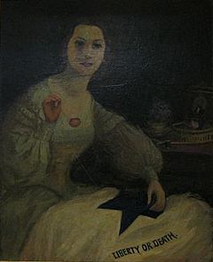
Joanna Troutman was born in Crawford County. She designed the first Lone Star flag. This flag later became the Texas State Flag. She gave her flag to a group of Georgia volunteers. They went to Texas in 1835 to help Texans fight for independence. The flag was first flown on January 8, 1836. Even though Troutman lived most of her life in Knoxville, her remains were moved to the Texas State Cemetery in Austin, Texas. A statue was built there to honor her. A portrait of Troutman also hangs in the Texas State Capitol building.
In 1775, a naturalist named William Bartram found a new plant in Crawford County. He named it Hydrangea Quercifolia, which we now call Oakleaf Hydrangea. Bartram described the area as a "delightful diversified rural scene." He said it "promises a happy, fruitful and salubrious region."
Crawford County pottery was a popular business in the 1800s and early 1900s. Men like Long, Becham, Merritt, Pyles, and Dickson were known for their useful jugs and crocks. The clay from Crawford County and the special glaze they used are still valued today.
There are many historic places to visit:
- Knoxville has the Old Jail Museum (built 1843). The Old Courthouse (built 1832, rebuilt 1851) holds old documents and local history. Knoxville also hosts the yearly Crawford County Pottery Jug Fest.
- Roberta has historic old town buildings. There is a copy of the original Train Depot and Passenger Station. You can also see the Benjamin Hawkins Monument. They are working on a rail car caboose for a railway museum.
- West of Roberta, off Highway US 80, is the Museum of Southeastern Indians. It has a collection of Native American artifacts. It also shows the history of Appalachian settlers.
- Musella has Dickey Farms (started 1897). It has one of Georgia's oldest peach packing houses (built 1936). Hays General Store (started 1900) has been open for over 110 years. It is one of the oldest stores of its kind in Georgia still running. Musella Baptist Church was founded in 1884. The current building was built in 1908. It is a beautiful example of a traditional country church.
Geography
Crawford County covers about 326 square miles. Most of this, about 325 square miles, is land. Only a small part, about 1.6 square miles, is water.
The county is split by something called the fall line. This means the northern part of the county is generally hillier. The southern part is flatter and has a lot of farmland. The Fall Line Freeway runs through a small part of the southern county.
The western part of Crawford County is in the Upper Flint River area. This river basin is called the ACF River Basin. The northeastern part is in the Upper Ocmulgee River area. A small southeastern corner is in the Lower Ocmulgee River area. Both Ocmulgee River areas are part of the Altamaha River basin.
Major Highways
Adjacent Counties
- Monroe County – north
- Bibb County – east-northeast
- Peach County – east-southeast
- Taylor County – southwest
- Macon County – south
- Upson County – northwest
- Houston County- Extreme East at Echeconee Creek
Communities
City
Census-designated place
Unincorporated communities
Demographics
| Historical population | |||
|---|---|---|---|
| Census | Pop. | %± | |
| 1830 | 5,313 | — | |
| 1840 | 7,981 | 50.2% | |
| 1850 | 8,984 | 12.6% | |
| 1860 | 7,693 | −14.4% | |
| 1870 | 7,557 | −1.8% | |
| 1880 | 8,656 | 14.5% | |
| 1890 | 9,315 | 7.6% | |
| 1900 | 10,368 | 11.3% | |
| 1910 | 8,310 | −19.8% | |
| 1920 | 8,893 | 7.0% | |
| 1930 | 7,020 | −21.1% | |
| 1940 | 7,128 | 1.5% | |
| 1950 | 6,080 | −14.7% | |
| 1960 | 5,816 | −4.3% | |
| 1970 | 5,748 | −1.2% | |
| 1980 | 7,684 | 33.7% | |
| 1990 | 8,991 | 17.0% | |
| 2000 | 12,495 | 39.0% | |
| 2010 | 12,630 | 1.1% | |
| 2020 | 12,130 | −4.0% | |
| 2023 (est.) | 12,277 | −2.8% | |
| U.S. Decennial Census 1790-18801890-1910 1920-1930 1930-1940 1940-1950 1960-1980 1980-2000 2010 |
|||
The table below shows the different groups of people living in Crawford County as of 2020.
| Race | Num. | Perc. |
|---|---|---|
| White (non-Hispanic) | 8,866 | 73.09% |
| Black or African American (non-Hispanic) | 2,267 | 18.69% |
| Native American | 45 | 0.37% |
| Asian | 31 | 0.26% |
| Pacific Islander | 3 | 0.02% |
| Other/Mixed | 503 | 4.15% |
| Hispanic or Latino | 415 | 3.42% |
In 2020, there were 12,130 people living in the county. There were 4,510 households and 3,122 families.
Education
See also
 In Spanish: Condado de Crawford (Georgia) para niños
 | William L. Dawson |
 | W. E. B. Du Bois |
 | Harry Belafonte |


