Macon County, Georgia facts for kids
Quick facts for kids
Macon County
|
|
|---|---|

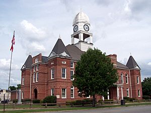
Macon County Courthouse in Oglethorpe, Georgia
|
|

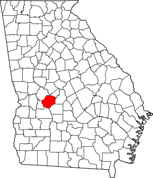
Location within the U.S. state of Georgia
|
|
 Georgia's location within the U.S. |
|
| Country | |
| State | |
| Founded | December 14, 1837 |
| Named for | Nathaniel Macon |
| Seat | Oglethorpe |
| Largest city | Montezuma |
| Area | |
| • Total | 406 sq mi (1,050 km2) |
| • Land | 401 sq mi (1,040 km2) |
| • Water | 5.4 sq mi (14 km2) 1.3%% |
| Population
(2020)
|
|
| • Total | 12,082 |
| • Density | 30/sq mi (10/km2) |
| Time zone | UTC−5 (Eastern) |
| • Summer (DST) | UTC−4 (EDT) |
| Congressional district | 2nd |
| Website | Macon County government |
Macon County is a county located in the central part of the U.S. state of Georgia. It's like a smaller region within the state. In 2020, about 12,082 people lived here. The main town, or county seat, where the county government is located, is Oglethorpe.
Contents
History of Macon County
Macon County was created in 1837. It was formed from parts of Houston and Marion counties. This happened on December 14 of that year. It was the 91st county in Georgia!
The county was named after General Nathaniel Macon from North Carolina. He was a very important person who served in the U.S. Congress for 37 years. He even ran for U.S. vice president. The city of Macon, Georgia, was also named after him. But remember, the city of Macon is in a different county called Bibb County. Later, parts of Macon County were used to create Taylor (in 1852) and Peach (in 1924) counties.
The first county seat was chosen in 1838. The county's local court picked a place called Lanier. The Georgia General Assembly (which is like the state's main law-making group) officially made it a town on December 29, 1838.
In the 1850s, the Central of Georgia Railroad was built through Oglethorpe. This changed things for the county. The Georgia Assembly asked people to vote on moving the county seat to Oglethorpe. This vote happened in 1854 and again in 1856. The second vote passed, and Oglethorpe became the new county seat in 1857.
During the American Civil War, a sad event happened nearby. About 13,000 Union soldiers, who were prisoners of war, died at a Confederate camp in Andersonville, Georgia. They died from hunger and sickness. During this time, Georgia also struggled to feed its own soldiers and people. Many soldiers on both sides of the war died from disease, not just from battle wounds. After the war, the leaders of the camp were put on trial for how they treated the prisoners. The Andersonville National Cemetery was created for the many Union soldiers who died there. It is located at the very southwest tip of Macon County.
Today, Macon County has an active Mennonite community. These are people who follow a certain Christian faith. The phone area code for Macon County is currently 478.
Geography and Nature
Macon County covers about 406 square miles. Most of this area, about 401 square miles, is land. The rest, about 5.4 square miles, is water. The county is located in the upper part of Georgia's Atlantic coastal plain. This is a flat area near the coast.
Most of the southern part of Macon County is in the Middle Flint River area. This river is part of a larger river system called the ACF River Basin. The northern and northwestern parts of the county are in the Upper Flint River area. The very northeastern corner of Macon County is in the Lower Ocmulgee River area. This river is part of the Altamaha River basin.
Main Roads
These are the most important roads that go through Macon County:
Neighboring Counties
Macon County shares borders with these other counties:
- Peach County (to the northeast)
- Houston County (to the east)
- Dooly County (to the southeast)
- Sumter County (to the south)
- Schley County (to the southwest)
- Taylor County (to the northwest)
Protected Areas
Part of the Andersonville National Historic Site is located in Macon County. This is a special place that is protected to remember its history.
Towns and Cities
These are the main towns and cities in Macon County:
Cities
- Ideal
- Marshallville
- Montezuma
- Oglethorpe (This is the county seat, where the main government offices are.)
People of Macon County
As of the 2020 United States census, there were 12,082 people living in Macon County. There were 4,696 households, which are groups of people living together, and 3,033 families.
Education
See also
 In Spanish: Condado de Macon (Georgia) para niños
 | Georgia Louise Harris Brown |
 | Julian Abele |
 | Norma Merrick Sklarek |
 | William Sidney Pittman |

