Andersonville, Georgia facts for kids
Quick facts for kids
Andersonville, Georgia
|
|
|---|---|
|
City
|
|

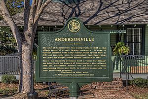
Andersonville historical marker
|
|

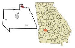
Location in Sumter County and the state of Georgia
|
|
| Country | United States |
| State | Georgia |
| County | Sumter |
| Area | |
| • Total | 1.39 sq mi (3.59 km2) |
| • Land | 1.38 sq mi (3.57 km2) |
| • Water | 0.01 sq mi (0.02 km2) |
| Elevation | 397 ft (121 m) |
| Population
(2020)
|
|
| • Total | 237 |
| • Density | 171.74/sq mi (66.33/km2) |
| Time zone | UTC-5 (Eastern (EST)) |
| • Summer (DST) | UTC-4 (EDT) |
| ZIP code |
31711
|
| Area code(s) | 229 |
| FIPS code | 13-02256 |
| GNIS feature ID | 0354310 |
Andersonville is a small city in Sumter County, Georgia, United States. In 2020, about 237 people lived there. It is located in the southwest part of the state.
Andersonville is famous because of a prisoner-of-war camp that was there during the American Civil War. This camp is now a special historical site called the Andersonville National Historic Site. The city is also part of the Americus micropolitan area.
Contents
History of Andersonville
The area was first named "Anderson" in 1853. It was named after John Anderson, who helped build the South Western Railroad. The railroad line was extended to the area that year.
The place was known as Anderson Station. But in 1855, the U.S. post office changed its name to "Andersonville." This was to avoid confusion with another post office in Anderson, South Carolina.
The Civil War Prison Camp
During the Civil War, the Confederate army built a prison camp here. It was called Camp Sumter. This camp held Union soldiers who were captured.
The prison, known as Andersonville Prison, became very crowded. Conditions were very difficult for the prisoners. Sadly, almost 13,000 prisoners died there.
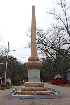
After the war, a person named Henry Wirz was found responsible for how the camp was run. Later, a monument was put up in Andersonville to honor him. This monument was placed by a group called the United Daughters of the Confederacy.
Andersonville During the War
Andersonville was also an important supply center during the war. It had a post office and a train depot. There was also a blacksmith shop and a stable. The town had a few general stores and two saloons. A school and a Methodist church were also in the town. About a dozen houses completed the small community. Ben Dykes owned the land where the prison was built. He was also the depot agent and postmaster.
After the War and Modern Times
For a long time, Andersonville's economy depended on farming. Farmers mainly grew cotton. This changed in 1968 when a company called Mulcoa started mining. They mined materials like kaolin and bauxite.
This mining operation changed about 2,000 acres of land. It became a large mining and refining site. Today, the company ships over 2,000 tons of refined ore from Andersonville each week.
In 1974, the mayor, Lewis Easterlin, and other citizens wanted to bring more visitors to the town. They worked to make Main Street look like it did during the Civil War. Now, the city of Andersonville and the Andersonville National Historic Site are popular places for tourists to visit.
Geography and Climate
Andersonville is located in Sumter County, Georgia. It covers an area of about 1.39 square miles (3.59 square kilometers). Most of this area is land.
Weather in Andersonville
The city has a warm climate. Summers are hot and winters are mild. Here is a look at the average temperatures and rainfall:
| Climate data for Andersonville, Georgia | |||||||||||||
|---|---|---|---|---|---|---|---|---|---|---|---|---|---|
| Month | Jan | Feb | Mar | Apr | May | Jun | Jul | Aug | Sep | Oct | Nov | Dec | Year |
| Mean daily maximum °F (°C) | 60 (16) |
62 (17) |
70 (21) |
78 (26) |
86 (30) |
91 (33) |
92 (33) |
92 (33) |
88 (31) |
79 (26) |
68 (20) |
61 (16) |
77 (25) |
| Mean daily minimum °F (°C) | 38 (3) |
40 (4) |
46 (8) |
53 (12) |
61 (16) |
68 (20) |
71 (22) |
70 (21) |
66 (19) |
55 (13) |
44 (7) |
39 (4) |
54 (12) |
| Average precipitation inches (mm) | 4.3 (110) |
4.8 (120) |
5.3 (130) |
3.9 (99) |
3.5 (89) |
4.3 (110) |
5.5 (140) |
4.9 (120) |
3.4 (86) |
2.3 (58) |
2.7 (69) |
4.0 (100) |
48.9 (1,240) |
| Source: Weatherbase | |||||||||||||
Population Information
The population of Andersonville has changed over the years. Here is a table showing the population from 1880 to 2020:
| Historical population | |||
|---|---|---|---|
| Census | Pop. | %± | |
| 1880 | 308 | — | |
| 1900 | 245 | — | |
| 1910 | 174 | −29.0% | |
| 1920 | 196 | 12.6% | |
| 1930 | 231 | 17.9% | |
| 1940 | 211 | −8.7% | |
| 1950 | 281 | 33.2% | |
| 1960 | 263 | −6.4% | |
| 1970 | 274 | 4.2% | |
| 1980 | 267 | −2.6% | |
| 1990 | 277 | 3.7% | |
| 2000 | 331 | 19.5% | |
| 2010 | 255 | −23.0% | |
| 2020 | 237 | −7.1% | |
| U.S. Decennial Census | |||
In 2000, there were 331 people living in Andersonville. About 65% of the people were White. About 35% were African American. A small percentage were Hispanic or Latino.
See Also
 In Spanish: Andersonville (Georgia) para niños
 | James Van Der Zee |
 | Alma Thomas |
 | Ellis Wilson |
 | Margaret Taylor-Burroughs |


