Schley County, Georgia facts for kids
Quick facts for kids
Schley County
|
|
|---|---|

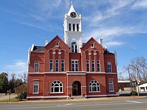
Schley County Courthouse in Ellaville
|
|

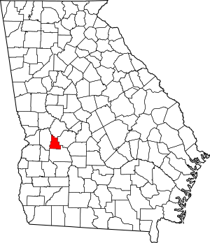
Location within the U.S. state of Georgia
|
|
 Georgia's location within the U.S. |
|
| Country | |
| State | |
| Founded | December 22, 1857 |
| Named for | William Schley |
| Seat | Ellaville |
| Largest city | Ellaville |
| Area | |
| • Total | 168 sq mi (440 km2) |
| • Land | 167 sq mi (430 km2) |
| • Water | 0.9 sq mi (2 km2) 0.5%% |
| Population
(2020)
|
|
| • Total | 4,547 |
| • Density | 27/sq mi (10/km2) |
| Time zone | UTC−5 (Eastern) |
| • Summer (DST) | UTC−4 (EDT) |
| Congressional district | 2nd |
Schley County (pronounced like "sly") is a county located in the middle-western part of the state of Georgia. In 2020, about 4,547 people lived there. The main town and county seat is Ellaville.
Schley County is part of the area around Americus. It was named after William Schley, who was a governor of Georgia.
Contents
History of Schley County
When Was Schley County Created?
Schley County was officially created on December 22, 1857. It was named to honor William Schley, who served as a representative in the United States Congress and was also the 36th governor of Georgia.
What About the Courthouses?
The very first courthouse for Schley County was built in 1858. The building that serves as the Schley County Courthouse today was built later, in 1899.
Geography of Schley County
How Big is Schley County?
Schley County covers a total area of about 168 square miles. Most of this area, about 167 square miles, is land. A small part, less than one square mile, is water.
What Rivers Are in Schley County?
The central part of Schley County, especially north of Ellaville, is located in the Middle Flint River area. This river basin is part of a larger system called the Apalachicola-Chattahoochee-Flint River Basin. The very northern edge of the county is in the Upper Flint River area. The southwestern part of the county, southwest of Ellaville, is in the Kinchafoonee-Muckalee area, which also connects to the larger river system.
Major Roads in Schley County
 U.S. Route 19
 State Route 3
 State Route 26
 State Route 153
 State Route 228
 State Route 240
 State Route 271
Counties Next to Schley County
- Taylor County (to the north)
- Macon County (to the east)
- Sumter County (to the south)
- Marion County (to the west)
Communities in Schley County
Cities in Schley County
- Ellaville (This is the county seat, meaning it's the main town where the county government is located.)
Other Small Communities
Population of Schley County
How Many People Live Here?
Over the years, the number of people living in Schley County has changed. In 1860, there were about 4,633 residents. The population grew over time, reaching its highest point in 2000 with 5,233 people. By the 2020 U.S. census, the population was 4,547 people.
Who Lives in Schley County?
In 2020, there were 4,547 people living in Schley County. Most residents, about 73.83%, identified as White (not Hispanic). About 18.98% identified as Black or African American (not Hispanic). Other groups, including Native American, Asian, Pacific Islander, and people of mixed races, made up smaller percentages. About 3.85% of the population identified as Hispanic or Latino.
See also
 In Spanish: Condado de Schley para niños
 | John T. Biggers |
 | Thomas Blackshear |
 | Mark Bradford |
 | Beverly Buchanan |

