Taylor County, Georgia facts for kids
Quick facts for kids
Taylor County
|
|
|---|---|

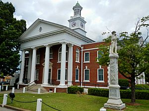
Taylor County Courthouse in Butler
|
|

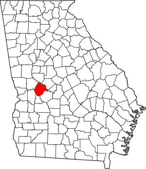
Location within the U.S. state of Georgia
|
|
 Georgia's location within the U.S. |
|
| Country | |
| State | |
| Founded | January 15, 1852 |
| Named for | Zachary Taylor |
| Seat | Butler |
| Largest city | Butler |
| Area | |
| • Total | 380 sq mi (1,000 km2) |
| • Land | 377 sq mi (980 km2) |
| • Water | 3.0 sq mi (8 km2) 0.8%% |
| Population
(2020)
|
|
| • Total | 7,816 |
| • Estimate
(2023)
|
7,758 |
| • Density | 20.57/sq mi (7.94/km2) |
| Time zone | UTC−5 (Eastern) |
| • Summer (DST) | UTC−4 (EDT) |
| Congressional district | 2nd |
Taylor County is a county located in the western part of Georgia. In 2020, about 7,816 people lived here. The main town and largest city is Butler.
Contents
History of Taylor County
Taylor County was created on January 15, 1852. The Georgia General Assembly (which is like Georgia's state parliament) made it by taking parts of Macon, Marion, and Talbot counties.
The county is named after Zachary Taylor. He was the twelfth President of the United States.
The land for the county's courthouse was bought from several people. These included Andrew McCants, John T. Gray, John Sturdivant, John L. Parker, and a Mr. Covington. This happened on March 8, 1852.
The county had several militia districts. These were areas for local defense groups. Some of these districts included Prattsburg, Hall, Reynolds, Butler, Cedar Creek, and Whitewater.
Geography of Taylor County
Taylor County covers about 380 square miles. Most of this area, about 377 square miles, is land. Only a small part, about 3.0 square miles, is water.
A special natural line called the Fall Line goes through Taylor County. This line divides two different types of land. The northern part of the county is in the Piedmont region. It has gently rolling hills and clay soil. The southern part is flatter. It is in the Upper Atlantic Coastal Plain and has more sandy soil. The Flint River forms the entire northeastern border of the county.
Farming and Forests
Taylor County's economy is mostly based on farming. Farmers here grow many crops. These include peaches, strawberries, pecans, peanuts, watermelons, and cotton.
Cutting down trees for wood, called lumbering, is also important. The county has many forests. This is partly because of large pine farms. There are also beautiful hardwood forests. These are found especially along the Flint River and its smaller streams. The southwestern part of the county has large sandhills. This has led to several sand mining businesses.
Animals and Plants
Taylor County has many different animals. You can find white-tailed deer, wild turkeys, rabbits, raccoons, and coyotes. Other animals include bobcats, armadillos, and opossums. Birds like the red-tailed hawk live here too. The Florida gopher tortoise, which is an endangered species, also calls Taylor County home.
The county has five types of venomous snakes. These include the eastern diamondback rattlesnake and the timber rattlesnake. Other snakes are the Carolina pigmy rattlesnake, the eastern coral snake, the water moccasin, and the copperhead.
The main trees in the area are the southern red oak and the post oak. You can also see longleaf pine, loblolly pine, sweetgum, and red maple. Taylor County has the largest groups of Atlantic white cedar trees in Georgia. These trees grow along Whitewater and Little Whitewater creeks. People are working to protect these special plant areas for the future.
Most of Taylor County is in the Upper Flint River area. This is part of a larger river system called the ACF River Basin. A very small part of the county, near Mauk, is in a different part of the same river basin.
Major Highways in Taylor County
Counties Next to Taylor County
- Upson County (north)
- Crawford County (northeast)
- Peach County (east)
- Macon County (southeast)
- Schley County (south)
- Marion County (southwest)
- Talbot County (northwest)
Communities in Taylor County
City
Town
Census-designated place
Other Unincorporated Communities
Population Changes in Taylor County
| Historical population | |||
|---|---|---|---|
| Census | Pop. | %± | |
| 1860 | 5,998 | — | |
| 1870 | 7,143 | 19.1% | |
| 1880 | 8,597 | 20.4% | |
| 1890 | 8,666 | 0.8% | |
| 1900 | 9,846 | 13.6% | |
| 1910 | 10,839 | 10.1% | |
| 1920 | 11,473 | 5.8% | |
| 1930 | 10,617 | −7.5% | |
| 1940 | 10,768 | 1.4% | |
| 1950 | 9,113 | −15.4% | |
| 1960 | 8,311 | −8.8% | |
| 1970 | 7,865 | −5.4% | |
| 1980 | 7,902 | 0.5% | |
| 1990 | 7,642 | −3.3% | |
| 2000 | 8,815 | 15.3% | |
| 2010 | 8,906 | 1.0% | |
| 2020 | 7,816 | −12.2% | |
| 2023 (est.) | 7,758 | −12.9% | |
| U.S. Decennial Census 1790-1880 1890-1910 1920-1930 1930-1940 1940-1950 1960-1980 1980-2000 2010 |
|||
As of the 2020 census, there were 7,816 people living in Taylor County.
See also
 In Spanish: Condado de Taylor (Georgia) para niños
 | Toni Morrison |
 | Barack Obama |
 | Martin Luther King Jr. |
 | Ralph Bunche |

